Booze & Slei Gill from Langthwaite
Yorkshire Dales Walk
Nat Park - Yorkshire Dales - Swaledale
County/Area - North Yorkshire
Author - Lou Johnson
Length - 2.5 miles / 4.1 km Ascent - 400 feet / 121 metres
Time - 1 hours 40 minutes Grade - easy
Maps 

| Ordnance Survey Explorer OL30 | Sheet Map | 1:25k | BUY |
| Anquet OS Explorer OL30 | Digital Map | 1:25k | BUY |
| Ordnance Survey Landranger 92 | Sheet Map | 1:50k | BUY |
| Anquet OS Landranger 92 | Digital Map | 1:50k | BUY |
Walk Route Description
Click image to visit gallery of 6 images.
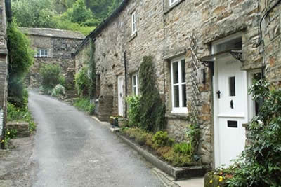
Although short, this Yorkshire dales walk includes all the characteristics of the northern part of this beautiful National Park. Beginning in a compact stone built village, it continues through pastures with dry stone walling to explore the remnants of the once extensive lead mining industry. The walk concludes with a pleasant section through deciduous woodland alongside Arkle Beck, one of the tributaries of the River Swale.
The start is the small car park in the centre of Langthwaite village (Grid ref. NZ005023). Should this be full do ensure that you park considerately and avoid causing any obstructions. After parking head northeast between stone cottages on the lane to Booze. This climbs steeply for a short way soon providing a bird's eye view over the village and Arkengarthdale.
Continue through the hamlet of Booze. The lane becomes a track, which contours the hillside eventually crossing the grassed-over remains of the lead mining to reach a barn. The track descends to Slei Gill. You can if you wish walk upstream and explore some more although this route turns back here and follows the Gill downstream. On the hillsides you can see the old 'hushes' where lead was found by scouring the hillside with water that had been temporarily dammed. Continue to follow Slei Gill, ignoring paths left and right. The path enters mature deciduous woodland before continuing alongside Arkle Beck and meadows back to the village.
Other walks nearby
| Walk 1252 | Great Pinseat | easy/mod | 5.5 miles |
| Walk 2190 | Calver Hill & Reeth Low Moor | easy/mod | 6.0 miles |
| Walk 1056 | Gunnerside & Surrender Bridge | moderate | 10.3 miles |
| Walk 1197 | Gunnerside & Swinner Gills | moderate | 8.5 miles |
| Walk 3093 | Bunton Hush, Blakethwaite & Gunnerside Gill | easy/mod | 5.5 miles |
| Walk 2469 | Great Allotment & God's Bridge | moderate | 10.2 miles |
| Walk 1340 | Muker & Upper Swaledale from Keld | easy/mod | 6.5 miles |
| Walk 1768 | Thomas Gill and Ravenseat from Tan Hill | moderate | 8.7 miles |
| Walk 1053 | Swinner Gill and Muker | mod/hard | 8.5 miles |
| Walk 1694 | Nappa Hall & Whitfield Gill Force | easy/mod | 6.0 miles |
Recommended Books & eBooks
Walking in the Yorkshire Dales: North and East
 This guidebook contains 43 circular day walks in the north and east Yorkshire Dales. It explores the dales, hills and moors between Kirkby Stephen and Pateley Bridge. Walking ranges from gentle 3 mile strolls to more strenuous day-long rambles across the Howgills, Wensleydale, Swaledale, Nidderdale, Mallerstang and Coverdale.
More information
Walking in the Yorkshire Dales: South and West
 Part of a two-book set, this guidebook describes 44 walks in the southern and western Yorkshire Dales, including the famous 23 mile Three Peaks circuit over Pen-y-Ghent, Whernside and Ingleborough. The other, mostly circular routes of 3½ to 13 miles cover the scenic region between Sedbergh, Kirkby Lonsdale, Settle, Skipton and Grassington.
More information
Messaging & Social Media
Message Walking Britain and follow the latest news.

Mountain Weather
Stay safe on the mountains with detailed weather forecasts - for iOS devices or for Android devices.