Walk 1262 - printer friendly version
Watersmeet & Foreland Point Walk
Author - Lou Johnson
Length - 10.5 miles / 17.1 km
Ascent - 3630 feet / 1100 metres
Grade - mod/hard
Start - OS grid reference SS793486
Lat 51.223794 + Long -3.7298342
Postcode EX35 6NQ (approx. location only)
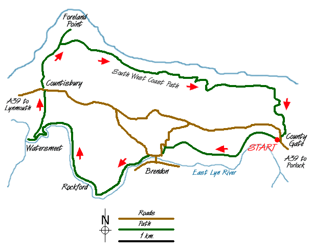
This walk, which stays within the County of Devon, contains four main elements including excellent valley paths, mature woodland, upland pastures and a spectacular section of the South West Coast Path that runs high above the shoreline. The start is the car park (Grid ref. SS793486) alongside the Exmoor National Park visitor centre at County Gate on the A39 between Porlock and Lynmouth. It is not an easy walk with a total ascent similar to many high mountain routes and it is worth noting that it involves a steep ascent right at the end. As a bonus, route finding is easy as Exmoor is noted for its high standard of signing.
From the car park take the signed path heading west to Brendon. Immediately you have the benefit of a fine view ahead as you descend gently for nearly two miles into the valley containing the East Lyn River. The path reaches a lane in Brendon. Turn left along the lane ignoring the road crossing the river to locate a signed footpath on your left leading to Watersmeet. This is a delightful section mainly in deciduous woodland and follows the river as it heads towards the sea. At times the path climbs above the river before dropping down to continue alongside it.
Stay on the path as far as Watersmeet where there are refreshments in season. Having explored the pretty spot where the two rivers meet, retrace your steps a short way back towards Brendon and locate a path on your left signed 'Contisbury'. This path climbs easily in a series of zigzags to lead you out of the woodland into open pasture and down to the A39. Turn left, taking care as this is a busy road, and cross to the car park. Exit the car park and continue north through the churchyard onto the South West Coast Path.
The onward section of path is straightforward. However it is worth mentioning that the effort to climb the short distance to the summit of the Foreland is rewarding as it offers a great spot to rest and take in the view. You also need to be mentally tuned to the idea that you still have plenty of climbing to do although admittedly its mostly in short sections. The switchback nature of the Coast Path is offset by the tremendous views as you steadily make progress east towards Porlock.
As one might expect the signage is good and you stay on the South West Coast Path for about three miles (5 km) to reach a cottage on your right in the Glenthorne Plantation. Passing this first obvious sign of habitation since leaving Contisbury, stay on the drive for a short way before descending left on the waymarked path. This leads you back to the track from where a signed path to 'County Gate' heads steeply uphill. If you have surplus energy then you can take the longer alternative route signed 'County Gate - Nature Trail' but most will opt for the direct route back to the start. As you struggle uphill you will certainly have reason to be pleased with yourself as you have completed a challenging and scenically delightful walk in the North Devon sector of the Exmoor National Park.
Messaging & Social Media
Message Walking Britain and follow the latest news.

Mountain Weather
Stay safe on the mountains with detailed weather forecasts - for iOS devices or for Android devices.