High Street & Kidsty Pike from Mardale Head
Lake District Walk
Nat Park - Lake District - Lake District Far Eastern Fells
Wainwrights - High Street, Kidsty Pike
County/Area - Cumbria
Author - Lou Johnson
Length - 7.5 miles / 12.2 km Ascent - 2700 feet / 818 metres
Time - 6 hours 30 minutes Grade - moderate
Maps 

| Ordnance Survey Explorer OL5 | Sheet Map | 1:25k | BUY |
| Anquet OS Explorer OL5 | Digital Map | 1:25k | BUY |
| Ordnance Survey Landranger 90 | Sheet Map | 1:50k | BUY |
| Anquet OS Landranger 90 | Digital Map | 1:50k | BUY |
Walk Route Description
Click image to visit gallery of 12 images.
This, in my humble opinion, is one of the best walks in the Lake District as it has just about all the features of the National Park contained in a simple yet challenging route. The description and photos below are based on a winter visit and include notes on sections that might be challenging with snow on the ground.
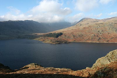
The start is the car park at Mardale Head (Grid ref. NY 468107). From here continue to the end of the road and go through the gate and take the first path on the right that leads across Mardale Beck to gain the far shore of Haweswater Reservoir where you turn right again heading towards the Rigg.
As the path climbs away from the shore of the reservoir look out for a steep path going half left. Take this and climb up to the wall that runs the length of the Rough Crag ridge. On reaching the wall turn left and follow the clear path to the summit of Rough Crag. The route is full of interest with typical Lake District views full of detail in all directions.
Descending from Rough Crag the path passes a small tarn with Long Stile ahead. This is an interesting climb with the option of a few scrambles for those who so desire. The ascent goes quickly and you are soon onto the summit of High Street. To reach the summit bear half left and the trig point will be found near the wall.
Continue by following the wall north. You descend to the Straits of Riggindale from where there is an excellent view the length of Riggindale, which is famous as being the home of the only paid of nesting Golden Eagles in England and Wales. As the path begins to climb again take the right fork. This leads without further problem to the rocky summit of Kidsty Pike.
Descend off the summit in an easterly direction to descend over the rocky outcrop of Kidsty Howes. From here the path continues in a bee-line to Bowderthwaite Bridge (Grid ref. NY 468118). Continue ahead on the clear path that climbs over the ridge to rejoin your outward path which is followed back to the car park.
Notes - This walk was undertaken in very cold weather after moderate snowfall, which had undergone some melting. All paths had sections of avoidable ice. Long Stile also had some tricky icy sections but again these were all avoidable. The final climb onto High Street was covered with snow. care needed to be taken to gain decent footholds. Once the summit has been gained no further problems apart from icy grass were encountered. The latter was surprisingly dangerous especially on the descent to Kidsty Howes.
Other walks nearby
| Walk 1152 | The Corpse Road and Selside Pike | moderate | 6.0 miles |
| Walk 3033 | Tarn Crag & Harrop Pike from Sadgill | moderate | 5.5 miles |
| Walk 1147 | Longsleddale and Kentmere Pike | moderate | 8.0 miles |
| Walk 1228 | Thornthwaite Beacon & High Street | moderate | 6.5 miles |
| Walk 1959 | Gray Crag and Pasture Beck from Hartsop | moderate | 5.5 miles |
| Walk 2585 | Hartsop Dodd, Stony Cove Pike, High St. & The Knott | mod/hard | 10.0 miles |
| Walk 3309 | Hartsop, Hartsop Dodd, Stony Cove Pike & Kirkstone Pass | moderate | 8.5 miles |
| Walk 2488 | Shipman Knotts & Kentmere Pike | moderate | 6.2 miles |
| Walk 1320 | Shorter Kentmere Horseshoe | mod/hard | 10.5 miles |
| Walk 2652 | Photographer's Kentmere Horseshoe | mod/hard | 13.5 miles |
Recommended Books & eBooks
Walking the Lake District Fells - Mardale and the Far East
 Part of the Walking the Lake District Fells series, this guidebook covers a wide range of routes to 36 Lakeland summits that can be climbed from the Ullswater, Haweswater, Troutbeck, Kentmere and Longsleddale valleys, with highlights including High Street, Place Fell and the Kentmere fells. Suggestions for longer ridge routes are also included.
More information
The Cumbria Way
 A guidebook to the 73 mile Cumbria Way, an easy long-distance walk though the heart of the Lake District National Park, from Ulverston in the south to Carlisle in the north, with good transport links to either end. The route is largely low-level but this guide offers alternative mountain days to climb some of the famous fells en route.
More information
Messaging & Social Media
Message Walking Britain and follow the latest news.

Mountain Weather
Stay safe on the mountains with detailed weather forecasts - for iOS devices or for Android devices.