Abney Circular
Peak District Walk
Nat Park - Peak District - Abney Moor Chatsworth
County/Area - Derbyshire
Author - P J B Steele
Length - 7.2 miles / 11.7 km Ascent - 1550 feet / 470 metres
Time - 5 hours 10 minutes Grade - easy/mod
Maps 

| Ordnance Survey Explorer OL24 | Sheet Map | 1:25k | BUY |
| Anquet OS Explorer OL24 | Digital Map | 1:25k | BUY |
| Ordnance Survey Landranger 119 | Sheet Map | 1:50k | BUY |
| Anquet OS Landranger 119 | Digital Map | 1:50k | BUY |
Walk Route Description
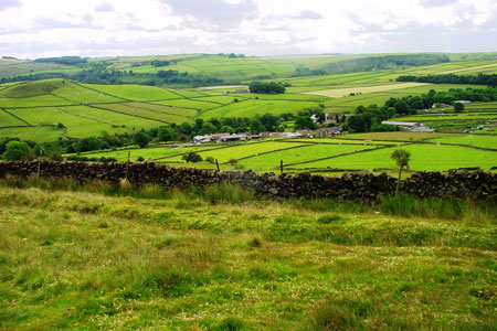
Click image to visit gallery of 7 images.
This is a circular Peak District walk centred on the Derbyshire village of Abney. Abney - which might more properly be termed a hamlet as there is no church or chapel - could probably compete with the poet Housman's Clunton, Clunbury, Clungunford and Clun (Shropshire) for the title of one of the quietest places under the sun. The settlement once had its own poet, William Newton born in 1750 at Cockey Farm - see below in Part II of route.
The route described has, in fact, a rough figure of 8 configuration and could be regarded as two walks in one, combining as it does the open expanses of Offerton Moor and Shatton Edge with their views of the High Peak and Hathersage Edge on the one hand and the almost claustrophobic intimacies of Bretton Clough and the other valleys around Abney Low on the other. The possibility of splitting the walk into two distinct walks is offered.
Part I - Offerton Moor and Shatton Edge
The start is a lay-by (grid ref. SK201799) some two hundred yards east of Fold Farm House. This can be reached by car coming in from the east along the lane from Leadmill Bridge on the B6011 just south of Hathersage or from the west from Great Hucklow by way of Camphill Gliding Field which places lie north of the A623. Public transport is non-existent even in the summer and walking to Abney from such centres as Bampford, Hathersage, Grindleford, Eyam or Great Hucklow would be a major additional effort whichever of these origins is selected. Bampford railway station is probably the most convenient alternative starting point in which case you would join the walk above Old Lees Farm at grid ref. SK201814.
From where you leave the car in Abney proceed north by way of the field boundary until the path swings east over a style onto open moorland. Follow the track up the face of Smelting Hill. On your left you will pass an old mine spoil heap and you may wish to divert up a narrow cleft beside it (obviously man-made) to inspect the ruins of the smelting house or 'bole' and the romantically over-grown remains of the mine which it served. Afterwards return to the well-defined path through the heather up the hill.
At the path cross-road (grid ref. SK202802), look south across the valley to the discrete formation of Abney Low which you will circle in part II of the walk. You are roughly at the same height as the summit of the low ( 'low' = hill in the Derbyshire dialect) so enjoy the view now as you will find no public right of access when you get to Cockey Farm - see below. To the east you will see the crags of Millstone Edge and Froggatt Edge.
Proceed NE over Smelting Hill through the heather onto Offerton Moor scanning the sky eagerly for birds of prey, skylarks, curlews and, of course, grouse. (Swaling is practiced on this grouse moor to keep down the bracken and this produces glorious heather by encouraging the young growth on which the grouse feed/nest). Descend to Siney Sitch ( 'sitch' = a moorland stream in the Derbyshire dialect) and then climb up again to Offerton Edge at grid ref. SK209809. (N.B. dogs should not be allowed to run free on the moor. Access is permissive except on the public footpath which you are on and the shooting is valuable to the owner). The path now turns due east and proceeds steeply down the bank to the wall of Offerton Hall.
Turn left in a westerly direction along the moor boundary crossing Old Clough (grid ref. SK208811) to the metalled lane running down to Old Lees Farm. (An alternative starting place for those walking in from Bampford - see above). Take a line a little south of west on the rough service road running up Shatton Edge to the radio mast at grid ref. SK194813. (Those walking with little boys may find them vastly and embarrassingly diverted by the name of this district - 'Shatton and Brough Parish'. Be prepared to turn their attention to more spiritual matters or, at least, to shame them into discretion.)
This is a good place to admire the views across the Hope Valley. Averting your gaze from the Hope cement works with its permanent pall of smoke/dust, see the southern end of the Ladybower Reservoir, the conical peak of Win Hill and, beyond that, the lowering mass of Kinder Scout. (Alternatively engage in a metaphysical debate on the morality of disfiguring a most glorious landscape for dubious economic ends! This may also amuse and distract the little boys!)
Carry on along Shatton Lane as it bends almost due south around the hill and then due east to the highest point of the walk at grid ref. SK193805. Those still with sufficient energy may wish to inspect Wolf's Pit open-cast mine while the more reflective will contemplate Abney Low and the crags on the eastern skyline from another angle and the heights of Abney Moor to the west. Gliders may also be seen soaring above Camp Hill.
If you decide to cut short the walk this is a good point. Simply cross the style and proceed in an easterly direction across Abney Moor following the line of the Fold Farm field boundaries to the old mine on Smelting Hill (see reference above) and then take the path by which you ascended back down to the car in the valley below. You have done pretty well considering: the time available to you; your age; the presence in your party of those less inclined to strenuous activity than yourself; etc. (Select the most appropriate excuse for ducking the second part of the challenge!).
Part II - Around Abney Low
However, for Heroes and the Firm of Purpose:
From the stile at grid ref. SK193805 follow the metalled lane back down into the centre of Abney village. Here turn right and proceed roughly SW along the lane to Camphill as far as the footpath opposite Ash House Farm. Follow the footpath down into Abney Clough ( 'clough' = a steep and narrow valley in the Derbyshire dialect) - very greasy in wet weather - and up the other side. The way becomes a little indistinct, but you should proceed a somewhat east of south across the fields to Cockey Farm - see reference above to the poet Newton - at grid ref. SK199793. Keep on roughly the same line down to Bretton Brook.
You then have a choice of paths along/down Bretton Clough - the main thing is to keep going downstream. As you make your way look out for the remains of the buildings of Gotherage Farm abandoned @ 1860 AD. Eventually you will hit the path that takes you down to the bridge at Stokes Ford (grid ref. SK211104). During all this time you will be skirting the foot of Abney Low on the other side of the brook and will see the buildings of Abneylow farm on the hillside to your left. (The clough floor - such as it is - is inaccessible).
From Stokes Ford you may chose to go on in a north westerly direction up Abney Clough. This will eventually bring you out opposite Fold Farm house where you should turn right along the lane back to the car. This offers a beautiful finale to the walk - albeit slippery in wet weather like all these valleys around Abney Low - and it can scarcely be called an easy option.
However, for those Indomitable Souls who are determined to complete the Abney Low experience, go east of north from the ford up through the wood to join the lane at Oaks Wood. Here take the drive up to Oaks Farm until you reach a fork in the path on the west side of the farmhouse at grid ref. SK210798. Here take the right fork up through the bracken (ignoring importunate sheep) to the crossing of the path at grid ref. SK202802 on Smelting Hill which you passed early in Part I of your expedition. Take one final look at the surrounding countryside - including Sir William Hill with its radio mast almost due south - and then walk back down the hill to your car conscious of a mission well accomplished.
Additional Notes - Andy Chaplin offers these additional notes. The start point for this walk offers space for only one car. The parking in Abney (certainly at weekends) is also difficult as several houses have no parking signs as do the sections of road where the farmers come out onto the narrow main road from their farmyards (sensible as they have to swing out with tractor and trailers). In the end we started at Grid ref. SK224780 at the east end of the unmade Sir William Hill Road. We walked down to Stoke Ford and came back to the start point from Nether Bretton. This adds just over 2 miles to the walk but makes it a guaranteed start point for more than one car.
Other walks nearby
| Walk 3620 | Bretton Clough & Abney Moor | easy/mod | 6.0 miles |
| Walk 1100 | Abney Moor & Bretton Clough | moderate | 8.5 miles |
| Walk 1080 | Shatton Moor and Offerton | easy/mod | 7.5 miles |
| Walk 2548 | Stanage Edge from Hathersage | moderate | 8.5 miles |
| Walk 1286 | Castleton Great Ridge & Mam Tor | moderate | 8.5 miles |
| Walk 2599 | Kinder Scout and Castleton Ridge from Hope | mod/hard | 13.5 miles |
| Walk 1706 | Win Hill from Hope | easy/mod | 6.5 miles |
| Walk 1090 | Stanage Edge | moderate | 7.0 miles |
| Walk 2588 | Win Hill & Hope Cross | moderate | 7.5 miles |
| Walk 1273 | Burbage Rocks & Padley Gorge from Hay Wood | moderate | 11.0 miles |
Recommended Books & eBooks
Walking in Derbyshire
 Walking guidebook to 60 circular day walks in Derbyshire and the Peak District. Includes the Derwent, Wye and Trent river valleys, near Derby, Matlock, Glossop, Bakewell and Ripley. Routes range from easy to moderate and are between 4 and 14km (2 to 10 miles). Walks focus on places of interest, from Stone Age forts to castles to grand estates.
More information
Walking in the Peak District - White Peak East
 Guidebook describing 42 half-day and day walks in the limestone landscapes of Derbyshire's White Peak, part of the Peak District National Park. One of two volumes, this book covers the east of the region, with potential bases including Bakewell, Eyam, Castleton, Birchover, Matlock and Wirksworth.
More information
Messaging & Social Media
Message Walking Britain and follow the latest news.

Mountain Weather
Stay safe on the mountains with detailed weather forecasts - for iOS devices or for Android devices.