Walk 1290 - printer friendly version
Mellbreak Walk
Author - Lou Johnson
Length - 7.0 miles / 11.4 km
Ascent - 2100 feet / 636 metres
Grade - moderate
Start - OS grid reference NY142210
Lat 54.576902 + Long -3.3288677
Postcode CA13 0RU (approx. location only)
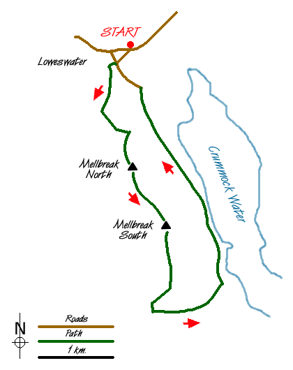
Mellbreak, in many respects, dominates Crummock Water despite the presence of much higher fells nearby. However its steep eastern flank plunges towards the shores of the lake and for most of the day casts a dark shadow across the water. This Lake District circular walk follows the main ridge of Mellbreak and does involve some mild scrambling. There are also a few sections where scree makes life a little uncomfortable.
The start is in the small parking area near the telephone box (Grid ref. NY142210) on the road into Loweswater from Vale of Lorton. After parking proceed down the lane towards the church. At the cross-roads by the pub, go right and immediately left to follow the lane past Kirkgate Farm and south towards Mosedale. Continuing in a walled lane you reach a small conifer plantation (Grid ref. NY 139201).
Leave the lane here and walk up through the trees with Mellbreak rising ahead. The path crosses an area of grass before slanting across the obvious scree slope. Taking a 'head-on' approach the path climbs steeply. There are a number of alternative routes with some sections where it is loose underfoot. Upward progress is quick although you may spend time finding the most suitable path. Reaching a rocky knoll you get the first of many grand views along Crummock Water and Buttermere.
The first and lower of Mellbreak's two summits is soon reached and you get a superb panorama in all directions. Going south an obvious path wends its way along the fell to the south summit. From here follow a similar line to descend to the bridleway through Mosedale (Grid ref. NY 146175). Turn left and continue to the shores of Crummock Water.
The return route is easy, following the shoreline although there are a few sections where the path is boggy. Where the path divides about a mile from Loweswater village, take the higher path. This leads via High Park and Low Park back to the cross roads at the start of the walk. Turn right along the lane in front of the church and you are soon back at the start after tcking Mellbreak off your list of Wainwrights.
Messaging & Social Media
Message Walking Britain and follow the latest news.

Mountain Weather
Stay safe on the mountains with detailed weather forecasts - for iOS devices or for Android devices.