Linton & Thorpe Fell & Cracoe
Yorkshire Dales Walk
Nat Park - Yorkshire Dales - Upper Wharfedale
County/Area - North Yorkshire
Author - Lou Johnson
Length - 9.0 miles / 14.6 km Ascent - 1400 feet / 424 metres
Time - 5 hours 50 minutes Grade - moderate
Maps 

| Ordnance Survey Explorer OL2 | Sheet Map | 1:25k | BUY |
| Anquet OS Explorer OL2 | Digital Map | 1:25k | BUY |
| Ordnance Survey Landranger 98 | Sheet Map | 1:50k | BUY |
| Anquet OS Landranger 98 | Digital Map | 1:50k | BUY |
Walk Route Description
Click image to visit gallery of 6 images.
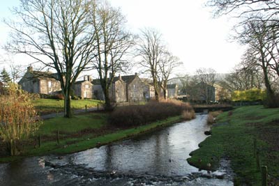
This Yorkshire Dales walk starts from the attractive village of Linton and takes a route high onto Burnsall and Thorpe Fell. It continues across the moors to the war memorial high above Cracoe village before returning to Linton using pleasant field paths. In poor visibility navigation on sections of the path across the moor may be difficult if you are inexperienced.
There is limited on street parking in the village of Linton (Grid ref. SD997627). After parking cross to the east bank of the stream and walk south turning east along the lane at a farm. Continue on this lane climbing gently. The track ends and you continue on field paths following a signed right of way to reach Thorpe Lane (Grid ref. SE 005621). Turn left and continue to a T-junction where you go right into Thorpe village.
Bear right at the next road junction in the heart of the village and continue along a lane. At the fork bear left and continue along the walled track climbing towards Thorpe Fell ahead. Shortly after the walled lane turns sharp left you reach open country (Grid ref. SE 011609). Continue ahead on a rough track that vaguely follows the stone wall on your left to reach a shooting cabin (Grid ref. SE 015600). Turn right along the clear track and walk west across open moorland to reach a wall (Grid ref. SE 000598) where you continue ahead in a south-westerly direction alongside the wall to the Cracoe War Memorial (Grid ref. SD 993588) which is reached by a ladder stile across the wall.
The next section requires some careful navigation across rough grass with a feint paths the only guide. From the obelisk descend northwest down a clear path that loses height quite quickly to the rough pasture below. Then take the easiest line across this rough meadow to reach the boundary wall (approx. grid ref. SD 985596). Turn right along the wall to reach the sheep pens adjacent to the entrance to Fell Lane (Grid ref. SD 987598).
Go down the lane into Cracoe village. Turn right along the main road continuing straight on where the main road veers left. Continue into Threapland Farm following the clearly signed track towards Linton. After a short way the paths leaves the track and goes right before continuing as true field paths all the way back to Linton. In general navigation is easy providing you leave the track as indicated above.
Other walks nearby
| Walk 1145 | Grassington, Mastilles Lane & Conistone Dib | moderate | 11.3 miles |
| Walk 1645 | Grassington, Mastilles Lane & Conistone Dib | moderate | 12.0 miles |
| Walk 1846 | Garnshaw House & Linton Falls from Grassington | easy | 3.0 miles |
| Walk 2610 | Hebden Gill & Cupola Corner | easy/mod | 6.5 miles |
| Walk 2611 | Hebden Gill from Hebden | easy | 4.0 miles |
| Walk 1576 | Embsay Reservoir | easy | 1.0 miles |
| Walk 1280 | Trollers Gill | moderate | 9.0 miles |
| Walk 2000 | Wharfedale Circular | moderate | 13.5 miles |
| Walk 1701 | Bordley Hall & Malham Moor from Threshfield Moor | easy/mod | 7.0 miles |
| Walk 3109 | Rylstone Edges & Cracoe from Rylstone | easy/mod | 6.0 miles |
Recommended Books & eBooks
Walking in the Yorkshire Dales: North and East
 This guidebook contains 43 circular day walks in the north and east Yorkshire Dales. It explores the dales, hills and moors between Kirkby Stephen and Pateley Bridge. Walking ranges from gentle 3 mile strolls to more strenuous day-long rambles across the Howgills, Wensleydale, Swaledale, Nidderdale, Mallerstang and Coverdale.
More information
Walking in the Yorkshire Dales: South and West
 Part of a two-book set, this guidebook describes 44 walks in the southern and western Yorkshire Dales, including the famous 23 mile Three Peaks circuit over Pen-y-Ghent, Whernside and Ingleborough. The other, mostly circular routes of 3½ to 13 miles cover the scenic region between Sedbergh, Kirkby Lonsdale, Settle, Skipton and Grassington.
More information
Messaging & Social Media
Message Walking Britain and follow the latest news.

Mountain Weather
Stay safe on the mountains with detailed weather forecasts - for iOS devices or for Android devices.