Walk 1299 - printer friendly version
Green Crag Walk
Author - Lou Johnson
Length - 6.5 miles / 10.6 km
Ascent - 1900 feet / 576 metres
Grade - moderate
Start - OS grid reference NY201009
Lat 54.397275 + Long -3.2321733
Postcode CA19 1TH (approx. location only)
Green Crag is one of those fells that is perhaps only visited if you are doing the "Wainwrights". Located south of Eskdale it occupies an area of rough moorland fell with few paths and the potential to be wet underfoot!
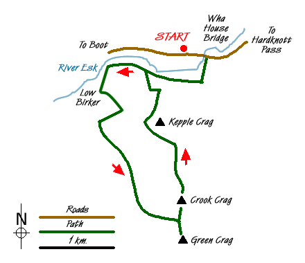
This Lake District walk starts from the small car park on the north side of the road from Eskdale to Hardknott Pass at Wha House Farm (Grid ref. NY201009). After parking walk east towards the River Esk. Cross the bridge and take the signed footpath on your right. This follows the river for a short way before entering woodland. Keep right at the junction (Grid ref. NY 203005) and continue past Penny Hill Farm to reach a road (Grid ref. NY 190007). Turn left and follow the track up to Low Birker staying with the rising right of way, a former peat road, as it climbs up hill using zigzags to ease the grade.
Continue on the peat road to pass a ruined stone hut. Shortly after passing this hut the track turns south with Birker Force waterfall below on your right. Stay on the track to reach Low Birker Tarn. Care is needed in this area as the moorland is wet underfoot. Staying with the path is probably advisable as it is likely to be even wetter away from the trodden route.
The path, always clear underfoot, passes beneath Tarn Crag on your left with Green Crag in view ahead. The path does not take a direct approach but uses the contours to avoid the wettest heathery swamps to reach a col between Crook Crag and Green Crag (Grid ref. NY 200985). From here turn right and climb the remaining 200 feet to the summit.
After enjoying and extensive view with the Scafells, Bowfell, Esk Pike and other peaks in view to the north. A less familiar fell is Black Combe to the south east, which is generally ignored by many walkers. Having taken in the view descend to the col and continue straight ahead and follow the path over Crook Crag. The path is at times indistinct and you need to follow your instincts heading roughly north across what is confusing ground to reach the path on the western flank of Kepple Crag (Grid ref. NY 197997). This path soon improves and looks more like its peat road origins as it descends to Penny Hill Farm. Turn right here and retrace your steps along the outward route to the road and car park.
Messaging & Social Media
Message Walking Britain and follow the latest news.

Mountain Weather
Stay safe on the mountains with detailed weather forecasts - for iOS devices or for Android devices.