Base Brown & Great Gable from Seathwaite
Lake District Walk
Nat Park - Lake District - Lake District Western Fells
Wainwrights - Base Brown, Great Gable, Green Gable,
County/Area - Cumbria
Author - Lou Johnson
Length - 6.0 miles / 9.8 km Ascent - 2750 feet / 833 metres
Time - 5 hours 50 minutes Grade - mod/hard
Maps 

| Ordnance Survey Explorer OL4 | Sheet Map | 1:25k | BUY |
| Anquet OS Explorer OL4 | Digital Map | 1:25k | BUY |
| Ordnance Survey Landranger 90 | Sheet Map | 1:50k | BUY |
| Anquet OS Landranger 90 | Digital Map | 1:50k | BUY |
Walk Route Description
Click image to visit gallery of 12 images.
Great Gable is, without doubt, one of Lakeland's finest mountains. The Lake District walk described below offers a varied and interesting approach that is generally quieter than other ways to Great Gable's summit.
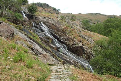
The start is Seathwaite Farm (Grid ref. NY235121) which is easily reached off the B5289 road through Borrowdale. After parking walk south towards the farm taking the signed footpath through the archway on your right. This leads to a substantial footbridge over the river before the path climbs steeply out of Borrowdale. The path is paved and climbs steeply with Sour Milk Gill on your right. Near the top there is a section of easy scrambling. In spate the proximity of the waterfalls can be very impressive.
Reaching the top the path levels and continues through a wide u-shaped valley towards Gillercomb. Here the path zigzags out of the valley to reach a broad grassy col (Grid ref. NY221111). The main path continue uphill but it is worth a short detour to your left to 'bag' the summit of Base Brown. Despite its unexciting summit, this Wainwright does offer a grand viewpoint for Borrowdale and the fells that surround this beautiful valley.
Return to the col and follow the path uphill. This section is none too exciting but you soon reach the main ridge path that connects Brandreth with Green Gable. Turn left on this path and the summit of Green Gable is soon reached. Offering excellent views across Western Lakeland, including Ennerdale and the High Stile ridge, the summit is sadly dominated by the adjacent bulk of Great Gable.
Descend south to Windy Gap and begin the climb to Great Gable's summit. The path is well-cairned and, in the early stages of the ascent, there are a few short sections of scrambling. However this is short lived and the cairn that marks the summit soon reached. The domed summit means that the best views are not enjoyed from the highest point and it is worth a short stroll downhill WSW towards the Westmorland cairn from where an outstanding view of Wasdale can be enjoyed.
To descend take the cairned path southeast (approx). After a short way the path is reconstructed and what used to be a tricky descent to Styhead can now be made without too much discomfort. Reaching the stretcher box turn left and gain the path on the west side of Styhead Tarn. Cross Styhead Gill using the new footbridge and descend easily to the top of Taylorgill Force waterfall. From here the path zigzags down into the valley to reach picturesque Stockley Bridge. Cross the bridge and follow the broad track back to Seathwaite and the start.
Other walks nearby
| Walk 1065 | Haystacks | moderate | 5.5 miles |
| Walk 1112 | Great Gable | hard | 7.3 miles |
| Walk 1245 | Castle Crag & Grange | easy/mod | 6.0 miles |
| Walk 1175 | Combe Gill Circuit | moderate | 5.5 miles |
| Walk 3328 | Eagle Crag & Seargeant's Crag from Stonethwaite | moderate | 7.0 miles |
| Walk 3133 | Ullscarf and Watendlath from Stonethwaite | mod/hard | 10.0 miles |
| Walk 1693 | Grange & Watendlath from Rosthwaite | easy/mod | 7.6 miles |
| Walk 1444 | Great Gable (Borrowdale route) | hard | 12.0 miles |
| Walk 1153 | The High Stile Ridge | hard | 10.0 miles |
| Walk 1289 | Fleetwith Pike & Haystacks | moderate | 5.5 miles |
Recommended Books & eBooks
Hadrian's Wall Path
 Hadrians Wall Path guidebook to walk the 84 mile National Trail. Described in both directions, the main description is west to east between Bowness-on-Solway and Wallsend, Newcastle, with extensions to Maryport and South Shields. With extensive historical information related to this World Heritage site and separate 1:25,000 OS map booklet included.
More information
Walking the Lake District Fells - Langdale
 Part of the Walking the Lake District Fells series, this guidebook covers a wide range of routes to 25 Lakeland summits that can be climbed from the Great Langdale valley, Ambleside and Grasmere, with highlights including Scafell Pike, Bowfell, the Langdale Pikes and Helm Crag (the Lion and the Lamb). Includes suggestions for longer ridge routes.
More information
Messaging & Social Media
Message Walking Britain and follow the latest news.

Mountain Weather
Stay safe on the mountains with detailed weather forecasts - for iOS devices or for Android devices.