Achmelvich Bay and Alltanabradhan
Highland Walk
County/Area - Highland - Northern Highland
Author - Lou Johnson
Length - 3.0 miles / 4.9 km Ascent - 600 feet / 182 metres
Time - 2 hours 10 minutes Grade - easy
Maps 

| Ordnance Survey Explorer 442 | Sheet Map | 1:25k | BUY |
| Anquet OS Explorer 442 | Digital Map | 1:25k | BUY |
| Ordnance Survey Landranger 15 | Sheet Map | 1:50k | BUY |
| Anquet OS Landranger 15 | Digital Map | 1:50k | BUY |
Walk Route Description
Click image to visit gallery of 9 images.
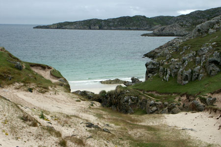
The coast of Assynt in north-west coast of Scotland is rugged and wild. This short walk explores the section of coast immediately north of Achmelvich Bay and visits the ruined grain mill at Alltanabradhan before following a little used path along the sea back to the sandy beach at Achmelvich. For those with a less intrepid nature you can always follow the outward route back to the start.
The start is the parking area at Achmelvich (grid ref. NC057247). This reached off the scenic B869 Lochinver to Unapool road. After parking take the signed track going north from the car park to Alltanabradhan. The way ahead is never in doubt as it undulates across the low coastal hills. After passing a few isolated houses the path eventually drops to cross a stream by some stepping stones. Bear left here down to the old grain mill where a board provides some useful historical background.
To continue walk downhill, towards the cove of Port Alltan na Bradhan. This is a perfect place to have a picnic and you are likely to have the beach to yourself for much of the time perhaps only disturbed by the sea birds and an occasional walker or two. You now have two choices. The easiest way back is to follow the outward route, which does offer a different perspective than that enjoyed on the outward walk. The other option is to follow a narrow path along the coast. This requires some patience and careful route finding. In one place there is the need for some mild scrambling.
Assuming you have opted for the latter course of action, leave the beach at its southern end and walk along the coast (with the sea on your right) picking your route carefully. The path is generally easy to follow although there are a couple of places where you have to do your own route finding. The advice in these places is to go carefully and choose the route you find most comfortable. Soon you will rejoin a clearer path and the way ahead returns to normal.
As mentioned before, there is one place where the use of hands is appropriate to scramble across some rocky ground. This does not last for long. All too soon you arrive at the glorious beach at Achmelvich with its turquoise sea and beautiful sand. After exploring the beach return to the car park at the top of the beach.
Other walks nearby
| Walk 1769 | Suilven (North-western approach) | hard | 12.0 miles |
| Walk 1316 | Falls of Kirkaig | easy | 5.8 miles |
| Walk 1266 | The Old Man of Stoer and the Point of Stoer | easy | 4.5 miles |
| Walk 2529 | Stac Pollaidh Circular | easy/mod | 2.8 miles |
| Walk 1017 | Stac Pollaidh | easy/mod | 3.0 miles |
| Walk 1317 | Sail Gharbh (Quinag) | moderate | 5.4 miles |
| Walk 1117 | Glas Bheinn & Eas a' Chual Aluinn (waterfall) | mod/hard | 8.5 miles |
| Walk 3272 | Conival & Ben More Assynt from Inchnadamph | hard | 11.0 miles |
| Walk 2274 | Cul Mor from Knockan Crag | mod/hard | 8.5 miles |
| Walk 1319 | The Bone Caves of Inchnadamph | easy | 3.0 miles |
Recommended Books & eBooks
Walking the Munros Vol 2 - Northern Highlands and the Cairngorms
 Guidebook to walking the northern Munros, covering the northern Highlands, the Cairngorms and the Isle of Skye. 70 routes are described, including those up Ben Macdui, Braeriach and Cairn Gorm. Routes range from 7 to 46km, requiring a fair level of fitness. The second of two guidebooks to walking Scotland's Munros: peaks higher than 3000ft.
More information
Skye's Cuillin Ridge Traverse
 This 2-volume set provides all the information required to complete the main ridge traverse on Skye's Black Cuillin. Strategy, gear, training, navigation and logistics are covered, and 10 classic scrambles are described. A lightweight second guidebook gives the scrambler detailed maps, topos and route description for the ridge traverse itself.
More information
Messaging & Social Media
Message Walking Britain and follow the latest news.

Mountain Weather
Stay safe on the mountains with detailed weather forecasts - for iOS devices or for Android devices.