Great Hetha and Elsdon Burn from Hethpool
Northumberland Walk
Nat Park - Northumberland
County/Area - Northumberland County
Author - Colin Corlett
Length - 4.0 miles / 6.5 km Ascent - 850 feet / 258 metres
Time - 2 hours 50 minutes Grade - easy/mod
Maps 

| Ordnance Survey Explorer OL16 | Sheet Map | 1:25k | BUY |
| Anquet OS Explorer OL16 | Digital Map | 1:25k | BUY |
| Ordnance Survey Landranger 74 | Sheet Map | 1:50k | BUY |
| Anquet OS Landranger 74 | Digital Map | 1:50k | BUY |
Walk Route Description
Click image to visit gallery of 5 images.
The College Valley has one access road from the B6351 between Wooler and Kirk Yetholm. At the bottom of the valley is a large car park which marks the limit of free public access by car. Beyond this point vehicular access is by permit only, with a day pass costing £ 12 from Sale and Partners (phone 01668 281611).
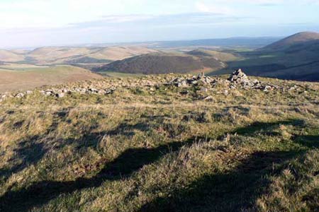
After parking, leave the car park walking up the valley. Right at the start look to your right where the valley is relatively flat. This is the original area of a stone circle and you can just make out the last remaining stones. As you pass a plantation on your right hand side you will come to a permissive path sign for Great Hetha. Follow this path uphill with the border of the plantation on your right hand side. As you come to the top of the plantation look to your left. There is a path heading up the hill to the top of Great Hetha. On the summit stop and look around you, you are in the middle of an ancient hill fort. These forts date back to the iron and bronze ages and this particular one is said to date from 500 BC.
From the summit you need to follow the ridge in a south westerly direction towards Trowupburn farmhouse. However before you reach the farm house you come to a stand of trees immediately before a small quarry. When you reach the quarry take the road northwards. This road takes you alongside the Hetha burn which eventually becomes the Elsdon burn. Half way long you come to a group of trees on your right hand side. One of these is a Wych Elm, quite a rare sight these days.
Eventually you come to a T-junction. Before you turn right back towards Hethpool, look up the hill on your left. A little way up here was an archeological dig by the University of Newcastle which sought to excavate medieval structures. As you walk back towards Hethpool the woodland on your left hand side is called the "Collingwood Oaks" after Admiral Collingwood who owned this estate in the early 19th century. For history buffs they would recognise him as the commander at Trafalgar who took charge when Nelson was injured. He had planted the oaks as an investment for the future. The oaks were vital to building new ships for the Royal Navy. However the oaks did not grow strong and true and anyway the development of iron hulls made them redundant.
Just after you pass Hethpool house on your left hand side, the road takes a sharp right hand turn. Here, on your right, are a group of cottages designed in 1926 by Robert Mauchlen for the then owner Sir Arthur Sutherland.They were constructed in the "arts and crafts" style and are widely viewed as amongst the finest in the National Park. On your left down in the Valley you can just see Hethpool Mill. This newly renovated house is available for weekly rent. There are records of a mill on this site going back to the 13th century. Shortly after you reach the car park, which was the start of the walk.
Other walks nearby
| Walk 2299 | The Cheviot | moderate | 9.0 miles |
| Walk 1201 | Black Hag from Kirk Yetholm | moderate | 8.5 miles |
| Walk 1764 | The Cheviot from Langleeford | mod/hard | 8.2 miles |
| Walk 1765 | Comb Fell & Hedgehope Hill from Langleeford | mod/hard | 8.9 miles |
| Walk 1776 | The Cheviot & Auchope Cairn from Langleeford | mod/hard | 10.0 miles |
| Walk 2152 | Hartshope Linn (waterfall) from Langleeford | easy | 4.4 miles |
| Walk 2153 | Housey Crags from Langleeford | easy/mod | 2.0 miles |
| Walk 2677 | Circuit of Doddington Moor | easy | 3.8 miles |
| Walk 1894 | Burnhope Reservoir Circular | easy | 2.8 miles |
| Walk 3296 | Grubbit Law & Hownam Law from Morebattle | moderate | 7.0 miles |
Recommended Books & eBooks
Walking in Northumberland
 This guidebook contains detailed route descriptions for 36 day walks in Northumberland including the Cheviot Hills. The terrain varies from wild walks and craggy ascents to gentle riverside strolls. Each route ranges from 4 to 16 miles in length and there is the opportunity to link several walks together to create longer treks.
More information
Hadrian's Wall Path
 Hadrians Wall Path guidebook to walk the 84 mile National Trail. Described in both directions, the main description is west to east between Bowness-on-Solway and Wallsend, Newcastle, with extensions to Maryport and South Shields. With extensive historical information related to this World Heritage site and separate 1:25,000 OS map booklet included.
More information
Messaging & Social Media
Message Walking Britain and follow the latest news.

Mountain Weather
Stay safe on the mountains with detailed weather forecasts - for iOS devices or for Android devices.