Walk 1314 - printer friendly version
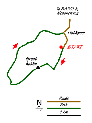
Great Hetha and Elsdon Burn from Hethpool Walk
Author - Colin Corlett
Length - 4.0 miles / 6.5 km
Ascent - 850 feet / 258 metres
Grade - easy/mod
Start - OS grid reference NT894281
Lat 55.546489 + Long -2.1695504
Postcode NE71 6TW (approx. location only)
The College Valley has one access road from the B6351 between Wooler and Kirk Yetholm. At the bottom of the valley is a large car park which marks the limit of free public access by car. Beyond this point vehicular access is by permit only, with a day pass costing £ 12 from Sale and Partners (phone 01668 281611).
After parking, leave the car park walking up the valley. Right at the start look to your right where the valley is relatively flat. This is the original area of a stone circle and you can just make out the last remaining stones. As you pass a plantation on your right hand side you will come to a permissive path sign for Great Hetha. Follow this path uphill with the border of the plantation on your right hand side. As you come to the top of the plantation look to your left. There is a path heading up the hill to the top of Great Hetha. On the summit stop and look around you, you are in the middle of an ancient hill fort. These forts date back to the iron and bronze ages and this particular one is said to date from 500 BC.
From the summit you need to follow the ridge in a south westerly direction towards Trowupburn farmhouse. However before you reach the farm house you come to a stand of trees immediately before a small quarry. When you reach the quarry take the road northwards. This road takes you alongside the Hetha burn which eventually becomes the Elsdon burn. Half way long you come to a group of trees on your right hand side. One of these is a Wych Elm, quite a rare sight these days.
Eventually you come to a T-junction. Before you turn right back towards Hethpool, look up the hill on your left. A little way up here was an archeological dig by the University of Newcastle which sought to excavate medieval structures. As you walk back towards Hethpool the woodland on your left hand side is called the "Collingwood Oaks" after Admiral Collingwood who owned this estate in the early 19th century. For history buffs they would recognise him as the commander at Trafalgar who took charge when Nelson was injured. He had planted the oaks as an investment for the future. The oaks were vital to building new ships for the Royal Navy. However the oaks did not grow strong and true and anyway the development of iron hulls made them redundant.
Just after you pass Hethpool house on your left hand side, the road takes a sharp right hand turn. Here, on your right, are a group of cottages designed in 1926 by Robert Mauchlen for the then owner Sir Arthur Sutherland.They were constructed in the "arts and crafts" style and are widely viewed as amongst the finest in the National Park. On your left down in the Valley you can just see Hethpool Mill. This newly renovated house is available for weekly rent. There are records of a mill on this site going back to the 13th century. Shortly after you reach the car park, which was the start of the walk.
Messaging & Social Media
Message Walking Britain and follow the latest news.

Mountain Weather
Stay safe on the mountains with detailed weather forecasts - for iOS devices or for Android devices.