Sail Gharbh (Quinag) from Kylesku
Highland Walk
County/Area - Highland - Northern Highland
Author - Lou Johnson
Length - 5.4 miles / 8.8 km Ascent - 1780 feet / 539 metres
Time - 4 hours 30 minutes Grade - moderate
Maps 

| Ordnance Survey Explorer 442 | Sheet Map | 1:25k | BUY |
| Anquet OS Explorer 442 | Digital Map | 1:25k | BUY |
| Ordnance Survey Landranger 15 | Sheet Map | 1:50k | BUY |
| Anquet OS Landranger 15 | Digital Map | 1:50k | BUY |
Walk Route Description
Click image to visit gallery of 9 images.
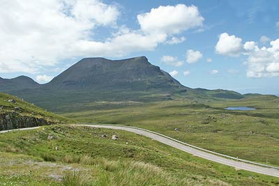
Quinag is an easily recognised hill that rises to the west of the A894 a few kilometres south of Kylesku. Like many hills in this region it stands out from the general lie of the surrounding land mainly because of its geological composition. Rising to 808 metres Quniag comprises three tops of Corbett status. Sail Gharbh is the highest point of Quinag, which is formed from three distinct ridges radiating from Bealach a' Chornaidh.
The start is the car park on the east side of the A894 (Grid ref. NC232273) located approximated three kilometres north of the A894/A837 junction. From here a distinct path leads west across a small footbridge. After a initial boggy section the path improves and continues without interruption past Lochan Bealach Chornaidh to reach Bealach Chornaidh.
Just before the bealach turn sharp right onto a clear path that rises steeply northeast upwards onto the Sail Gharbh ridge. The rock strewn ridge is soon reached and it is a short walk to the summit cairn from where there is a 360 degree panorama of superb quality. Included in the view are all the main peaks of Assynt and beyond including Suilven, Canisp, Ben More Assynt, Foinaven and Arkle (amongst others).
The return route follows the outward route although you may wish to explore the other two summits (Sail Gorm and Spidean Coinich) that are an integral part of this magnificent hill.
Other walks nearby
| Walk 1117 | Glas Bheinn & Eas a' Chual Aluinn (waterfall) | mod/hard | 8.5 miles |
| Walk 3272 | Conival & Ben More Assynt from Inchnadamph | hard | 11.0 miles |
| Walk 1319 | The Bone Caves of Inchnadamph | easy | 3.0 miles |
| Walk 1769 | Suilven (North-western approach) | hard | 12.0 miles |
| Walk 1316 | Falls of Kirkaig | easy | 5.8 miles |
| Walk 1312 | Achmelvich Bay and Alltanabradhan | easy | 3.0 miles |
| Walk 2274 | Cul Mor from Knockan Crag | mod/hard | 8.5 miles |
| Walk 2529 | Stac Pollaidh Circular | easy/mod | 2.8 miles |
| Walk 1017 | Stac Pollaidh | easy/mod | 3.0 miles |
| Walk 3261 | Handa Island - Scottish Wildlife Trust | easy | 4.0 miles |
Recommended Books & eBooks
Skye's Cuillin Ridge Traverse
 This 2-volume set provides all the information required to complete the main ridge traverse on Skye's Black Cuillin. Strategy, gear, training, navigation and logistics are covered, and 10 classic scrambles are described. A lightweight second guidebook gives the scrambler detailed maps, topos and route description for the ridge traverse itself.
More information
Walking the Munros Vol 2 - Northern Highlands and the Cairngorms
 Guidebook to walking the northern Munros, covering the northern Highlands, the Cairngorms and the Isle of Skye. 70 routes are described, including those up Ben Macdui, Braeriach and Cairn Gorm. Routes range from 7 to 46km, requiring a fair level of fitness. The second of two guidebooks to walking Scotland's Munros: peaks higher than 3000ft.
More information
Messaging & Social Media
Message Walking Britain and follow the latest news.

Mountain Weather
Stay safe on the mountains with detailed weather forecasts - for iOS devices or for Android devices.