Walk 1325 - printer friendly version
Horncastle, Langton & Thimbleby circular Walk
Author - Hugh Marrows
Length - 6.0 miles / 9.8 km
Ascent - 50 feet / 15 metres
Grade - easy/mod
Start - OS grid reference TF259696
Lat 53.208563 + Long -0.11630667
Postcode LN9 5BL (approx. location only)
This walk explores the hills surrounding Horncastle and includes extensive views to Lincoln and the Wolds. It crosses some arable fields but all paths are all clearly marked. There are several inns etc in Horncastle and the walk passes the Durham Ox inn at Thimbleby. Three villages are visited; Thornton, Langton and Thimbleby each of which had a new church within eleven years of each other between 1879 and 1890.
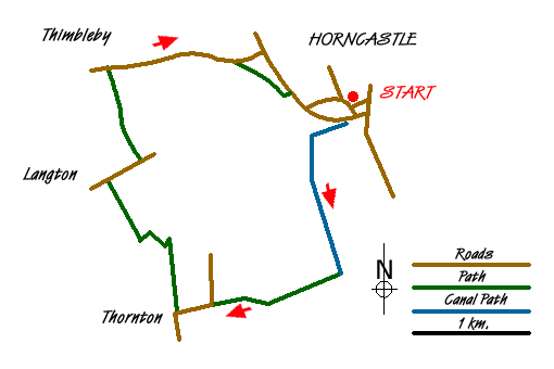
We leave Horncastle via St Mary's church and the town's old dispensary overlooking the churchyard. For a while beyond Coronation Walk we follow the Horncastle canal, which finally opened in 1802, although its construction had begun in 1796. There were eight locks and we pass the "first and last" of these on our way to Thornton. The canal finally closed on 7th May 1878.
The brick tower seen in the field by the lane at Thornton Lodge is the remains of a wind pump operated water system that supplied water to the nearby farm. The Horncastle branch line railway, which ran beside the canal here, was largely responsible for the latter's closure, but now itself disused has a fresh "life" as the Spa Trail / Viking Way to Woodhall Spa.
On the hilltop in Thornton village St Wilfred's church stands secluded down a dead-end lane. It was heavily restored in 1890; note the outside frame in the gable end for the bell and the unusual wooden porch.
St Margaret's at Langton was also much restored also in 1890 though a little mediaeval stonework remains in the north aisle - visible from outside if you can't get in. If you can, look for the unusual font made from several bits of masonry, the base being part of a Norman roof vault. There's a welcome seat in the churchyard too for anyone needing a rest! Watch out too for a rare "VR" letterbox opposite the church gate and nearby a curious abandoned cottage with church style windows among trees beside the lane.
Thimbleby's name probably comes from the Danish for "Thymli's farmstead" but when the Domesday Book was written had become "Stimblebi". Today with its thatched cottages it is one of the prettiest villages in the locality. We enter the village past the 1830 Wesleyan chapel and in the main street come to another St Margaret's, marginally, the oldest church seen today having been built in 1879 at a cost of £ 1,587. Nearby is the old school (1857), now the village hall, and the former village pump.
Route Guide
From the Market Place walk through the churchyard, cross the by-pass and turn right along Coronation Walk beside the River Waring. Cross two bridges near the swimming pool and then go left on either side of the canal and head out of town. Follow the canal to Thornton Bridge.
Bear right up the road here until you meet the B1191, cross to the pavement opposite and turn left. (The first right hand turn leads to the church; visit and return) Continue to the junction with Ox Pasture Lane and turn right, shortly leaving to the right at a footpath sign near the first bend. Pass behind a cottage along a farm track. In 150 yards at a waymark a footpath departs leftwards over a field, but the track is a permissive path and gives easier walking. It passes some woods before turning left by a hedge where the field path rejoins from the left at a right hand bend. The track continues to a farmyard entrance. Here climb the stile to your left and keep forward past a barn and between fences to reach the road in Langton.
Turn right and 200 yards beyond the church climb the stile on the left to cross an arable field and aiming towards the right hand corner of woodland seen in the shallow valley ahead. (The views extend to Lincoln on this bit!) Keeping right of the trees cross a footbridge then walk up the next field and along the short Chapel Lane into Thimbleby. Turn right through the village.
Beyond the church cross the road when the pavement swaps sides, pass the Durham Ox (or not as you feel inclined!) and go over the end of Mill Lane. Just after the last house, by Thimbleby's village nameplate, take the footpath going off half right; now with views over Horncastle and the Bain Valley to the Wolds beyond. Walk over two fields aiming down to a hedge corner near new houses. Turn left downhill where a footpath behind gardens eventually meets Lincoln Road. Turn right.
Messaging & Social Media
Message Walking Britain and follow the latest news.

Mountain Weather
Stay safe on the mountains with detailed weather forecasts - for iOS devices or for Android devices.