Kimmeridge & Tyneham
Jurassic Coast Walk
Region - Jurassic Coast
County/Area - Dorset
Author - Lou Johnson
Length - 6.8 miles / 11 km Ascent - 1300 feet / 394 metres
Time - 4 hours 40 minutes Grade - easy/mod
Maps 

| Ordnance Survey Explorer OL15 | Sheet Map | 1:25k | BUY |
| Anquet OS Explorer OL15 | Digital Map | 1:25k | BUY |
| Ordnance Survey Landranger 194 | Sheet Map | 1:50k | BUY |
| Anquet OS Landranger 194 | Digital Map | 1:50k | BUY |
Walk Route Description
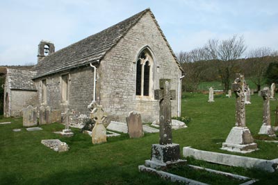
Click image to visit gallery of 9 images.
This varied walk combines dramatic seascapes with the interesting story of a deserted village. The route also passes one of Britain's few land based oil wells and includes a section of fine ridge walking. Sections of this walk cross the firing ranges and you are advised to take heed of all warnings in respect of path closures. In addition it is recommended you stay on marked paths and do not touch any suspicious objects that you might find.
The start is the small car park located in a quarry above the village of Kimmeridge (Grid ref. SY918800). After parking cross the road and go right for a short distance and take the signed footpath. This descends into the village of Kimmeridge passing the church on your right to reach a lane. Turn right along the lane and go through the gate. Go half left across the field passing a coppice on your right. Turn and go half left across the field to drop down to the small stream. Follow this through fields and over stiles to reach a road. Turn left along the road past some houses to turn right across a car park to reach the coastal path and the sea.
Turn right onto the South West Coast Path (although you might wish to make the short diversion left to visit the Clavel Tower). The Coast Path is followed for the next section of the walk passing the oil well with its "nodding donkey" before climbing onto Tyneham Cap. Throughout this section there are excellent views of Kimmeridge Bay and the Dorset coast westwards to Lulworth Cove.
Reaching the summit of Tyneham Cap you will probably need a rest and it does provide a wonderful vantage point although it can be windswept as evidenced from the shape of the small trees! Continue west towards Gad Cliff (approaching 500 feet high) before turning right on a clear path down to Tyneham Village.
During 1943 the Ministry of Defence requisitioned the village of Tyneham and the surrounding countryside as part of the efforts to train troops for the D-Day landings. What remains of the village has been preserved with the former church and school housing small exhibitions. There is also a pleasant picnic area with the whole village having a 1940's 'feel'.
After completing your exploration of Tyneham village retrace your steps up to Tyneham Cap. Instead on following the Coastal Path stay on the high ground and follow the clearly defined ridge east with excellent views across much of Purbeck. Reaching a path junction (Grid ref. SY 909 801) go half right and descend towards Kimmeridge village with its pleasant church (passed earlier), thatched cottages and a small cafe. To return to the start take the path to the east of the churchyard, which leads back to the quarry. Note - as an alternative you can continue on the ridge from SY909801 to reach the start thus omitting a visit to the Kimmeridge village.
Other walks nearby
| Walk 2145 | Houns-tout Cliff from Kingston | easy | 3.5 miles |
| Walk 2568 | Egmont Point & Kimmeridge Bay from Tyneham | moderate | 14.0 miles |
| Walk 1533 | Gad Cliff, Povington Hill & Tyneham | easy/mod | 4.5 miles |
| Walk 2925 | St Aldhelm's Head near Worth Matravers | easy | 4.1 miles |
| Walk 3286 | Dancing Ledge & Durlston Head from Langton Matravers | easy/mod | 7.0 miles |
| Walk 1004 | Durdle Door & Lulworth Cove | easy | 2.5 miles |
| Walk 1329 | Durdle Door & White Nothe from Lulworth Cove | moderate | 7.0 miles |
| Walk 3389 | Bindon Hill and the Fossil Forest from Lulworth | easy/mod | 4.0 miles |
| Walk 2579 | Purbeck Coast from Swanage | moderate | 10.0 miles |
| Walk 1634 | Old Harry & Ballard Down from Studland | easy/mod | 5.3 miles |
Recommended Books & eBooks
Walking the Jurassic Coast
 This guidebook includes 30 walks on the Jurassic Coast of Devon and Dorset. Covering the coast between Exmouth and Bournemouth, these delightful routes range from 3 to 16 miles (5 to 24km), exploring and explaining the spectacular geology of this World Heritage area with clear, easily understood descriptions, cross-sections and timelines.
More information
South West Coast Path Map Booklet - Minehead to St Ives
 Map of the northern section of the 630 mile (1014km) South West Coast Path National Trail. Covers the trail from Minehead to St Ives along the north Devon and Cornish coastline. This convenient and compact booklet of Ordnance Survey 1:25,000 maps shows the route, providing all of the mapping you need to walk the trail in either direction.
More information
Messaging & Social Media
Message Walking Britain and follow the latest news.

Mountain Weather
Stay safe on the mountains with detailed weather forecasts - for iOS devices or for Android devices.