The Ridgeway at the End of the Chilterns from Watlington Hill Walk
Walk 1335 - Route Maps
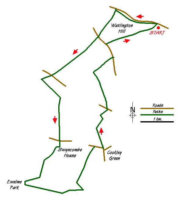
Route Map
Digital Maps - Copyright © 2011-2024. All rights reserved.
Sketch Map
Suggested Maps 

| Ordnance Survey Landranger 165 | Sheet Map | 1:50k | BUY |
| Anquet OS Landranger 165 | Digital Map | 1:50k | BUY |
It is recommended you take a map. The preferred scale is 1:25k.
Start Point Details
Ordnance Survey Grid Ref SU709936
Latitude 51.636748 Longitude -0.976919
Postcode OX49 5HS
what3words start sentences.wreck.validated
Walk description may contain detailed information on the start point for this walk.
Further Information
Chilterns
The Chilterns lie only a few miles to the north west of London and yet they are a beautiful, unspoilt corner of England. The gently rolling hills are swathed in woodland and chalk downland and in quiet valleys attractive villages with their traditional brick and flint cottages nestle around medieval churches. The most dramatic feature of the area is the chalk escarpment, a ridge running south west to north east, which rises up steeply from the Vale of Aylesbury and slopes gently south east towards London. This underlying chalk geology gives rise to clear chalk streams which are home to valuable wildlife. Chilterns Walking Guide
Oxfordshire
The County of Oxfordshire is located between the River Thames in the south, the Cotswolds to the west and the Chilterns in the east. Much of the county's wealth was from wool production in what is predominantly agricultural area. Local Government reorganisation in 1974 saw changes to the county boundaries with the Vale of White Horse and an area south of the Thames added to the county. Oxfordshire includes sections of three Areas of Outstanding Natural Beauty - the Cotswolds, the North Wessex Downs, and the Chilterns. Long-distance footpaths include the Ridgeway, Macmillan Way, Oxfordshire Way, and the D'Arcy Dalton Way. The Thames path follows the river and the valleys of the Thame, Windrush and Cherwell tributaries also provide excellent walking. The Oxford Canal follows the Cherwell from Banbury to Kidlington and again provides some excellent walking on the well-maintained tow path.
Walk grading - Learn how each walk is assessed and select a walk to suit your ability and experience by going to Walk Grading Details.
Messaging & Social Media
Message Walking Britain and follow the latest news.

Mountain Weather
Stay safe on the mountains with detailed weather forecasts - for iOS devices or for Android devices.