Pentre Bach circular from near Tregaron
Cambrian Mountains Walk
Region - Cambrian Mountains
County/Area - Ceredigion
Author - Dafydd Wyn Morgan
Length - 9.5 miles / 15.4 km Ascent - 700 feet / 212 metres
Time - 5 hours 30 minutes Grade - easy/mod
Maps 

| Ordnance Survey Explorer 199 | Sheet Map | 1:25k | BUY |
| Anquet OS Explorer 199 | Digital Map | 1:25k | BUY |
| Ordnance Survey Landranger 135 | Sheet Map | 1:50k | BUY |
| Anquet OS Landranger 135 | Digital Map | 1:50k | BUY |
| Ordnance Survey Landranger 146 | Sheet Map | 1:50k | BUY |
| Anquet OS Landranger 146 | Digital Map | 1:50k | BUY |
Walk Route Description
Click image to see photo description.
This circular walk starts from Pentre Bach in Blaenpennal village. The route consists of mostly quiet country lanes, but some very boggy and rough terrain by Llyn Fanod. Otherwise the walk follows variably defined paths across sheep pasture and moorland. Also you get to see the sea!
1 - From the post box outside Pentre Bach, turn left and down the hill to a bridge. Cross this, and climb steeply to reach a T-junction. Turn left towards Blaenpennal church and continue up past the church road and on to a junction at the top of a small quarry where you turn left again (still on a country lane).
2 - Bend right on the major road by Bryn Saron, where the road briefly heads more steeply uphill, before levelling out by Pen Lon. Then turn left at a T-junction towards Penuwch. Short-cutters can avoid the loop around Llyn Fanod by turning right and following from point 6 but it is recommended that you at least walk far enough to obtain a view of the lake.
3 - Follow the road with Llyn Fanod on your right. Ignore a footpath sign leading right, keep on the road as it bends sharply to the right (with a small pond on your left) and then on the next sharp bend to the left bear right (after Bryn tair llyn), onto a muddy access track running just left of a barbed wire fence. Roughly follow the fence line - the track becomes very boggy and indistinct in places.
4 - As the lake comes into view, turn right over a stile (beware there may be a bull in the field and dogs must be put on a lead at this point). Head over rough tussocky ground, initially towards an old wooden post, then roughly straight ahead to gain the right (south-eastern) bank of the lake ahead. Bend right and over a stile at the lake edge.
5 - Continue as close as reasonably possible to the lake shore over rough, boggy, tussocky ground, to reach another stile. Cross this, following the lake shoreline, and over a further two stiles to reach the tail of the lake. Bear sharp right along the fence lien, and cross a further stile in the far right corner of this field to gain a muddy access track. This leads back to the road junction with one more stile to cross, at the end of point 2.
6 -Turn left onto tarmac again (towards Bontnewydd) and head gently downhill past a plantation on the left. Take the second right (to Bontnewydd), passing entrances to Bryn Lociau and Maes Newydd to reach a T-junction by a small property. Turn left towards Llanrhystud, and climb gently past Bronant Forest (recently part-felled). Shortly after the road begins to rise once more, turn right towards Llyn Eiddwen. Continue steadily uphill with glimpses of the lake on the left. Continue past the radio transmitter mast, where the road bends left and downhill to give even better views down the length of the lake.
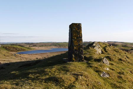
7 - Continue over a cattle grid (dogs on short lead here as you enter Llyn Eiddwen Nature Reserve) then after approximately 200m along the road, take a narrow grassy path veering off into tussocky open ground. Roughly opposite a small rocky knoll on the left. This rises towards a wider grassy track cutting across the ridgeline roughly half way between the knoll and a prominent stack (Mynydd Bach monument) at the far end of the ridge. Cross a rutted track to gain a wider grassy track, and continue through a shallow cutting with views of the sea and Cardigan Bay. Now continue over the broader grassy ridge on a fainter track before heading right on a more distinct track joining from the left to regain the tarmac road. Alternatively wander along the rougher grassy/rocky ridgeline to gain the Mynydd Bach monument on your right, before veering back to join the track to the tarmac road.
8 - Turn left onto the tarmac road, and bend right. As the road bends left, veer right on a stony track following the fence line on the right. Join a tarmac track to the right, and shortly after a small lorry graveyard, bear right onto a stony track (as the road bends left). Continue past a memorial to two RAF pilots and head back over the ridgeline.
9 - As the track bears left, follow rougher muddier track right, which bends gently left before a junction with fainter tracks. For a wonderful view of Cardigan Bay, the Llyn Peninsula and the Preseli Mountains, visit the trip point at Hafod Lithel. Continue straight ahead over very wet and sometimes even flooded section. The track now becomes less distinct and veers gently left as the ridgeline rises to the right. Continue heading gently downhill to meet an emerging stony track from the right. Turn left, and ford a small stream. Immediately after this, fork right; then start looking for an extremely faint and narrow path which heads towards the left edge of the plantation to the right. If you start rising up the ridgeline, you've gone too far! It may help to locate a sunken double line of reeds, just below the path, or a rusty fodder ring further along the line of the path. Hoof prints mat also indicate the way. Regardless, the path eventually becomes more distinct.
10 - Pass through a gap in the fence line just to the left of a corner of the plantation. The path now bends gently left and uphill to reach a rusty metal gate. Continue through this, and a set of vehicle tracks briefly joins the track from the right. Where they veer left (80m ahead), fork right, then bend right to run below another short ridgeline to reach a second gate near to another corner of forestry.
11 - Follow the vague line of the track leftwards to gain a third gate, where the track becomes more distinct. Continue down the track past a fourth gate which heralds Tanyresgair house and the start of the tarmac. Follow the tarmac track for roughly 1km to reach a country lane. Turn right to descend moderately steeply to a T-junction outside Bontnewydd.
12 - Turn left and generally descend for 1km over a couple of bridges, then arise for a similar distance to regain the junction just west of Pentre Bach. Turn left at this (sign-posted Tregaron), descend the hill to the bridge, and rise back up to Pentre Bach.
Other walks nearby
| Walk 1362 | Tregaron & Cors Caron circular | easy | 4.0 miles |
| Walk 1361 | Tregaron & Twm Town circular | easy | 3.5 miles |
| Walk 1364 | Tregaron & Llandewi Brefi circular | easy/mod | 4.5 miles |
| Walk 1367 | Cwm Berwyn from Tregaron | moderate | 11.0 miles |
| Walk 1363 | The Elephant Walk from Tregaron | easy/mod | 5.5 miles |
| Walk 1365 | Strata Florida to Tregaron | moderate | 9.5 miles |
| Walk 2736 | Teifi Pools from near Strata Florida | easy/mod | 6.2 miles |
| Walk 1767 | Allt Wen & Wales Coast Path from Trefechan | easy/mod | 6.0 miles |
| Walk 3086 | Pen y Garn from near Devil's Bridge | easy/mod | 6.8 miles |
| Walk 2048 | Craig-y-Pistyll, Cambrian Mountains | moderate | 10.0 miles |
Recommended Books & eBooks
The Wales Coast Path
 A single guidebook to walking the whole Wales Coast Path - 1400km (870 miles) the length of Wales from Chester to Chepstow, including Anglesey, described in 57 stages. The route passes through the Snowdonia and Pembrokeshire National Parks and many AONBs and can be linked with the Offa's Dyke Path for a complete circuit of Wales.
More information
Messaging & Social Media
Message Walking Britain and follow the latest news.

Mountain Weather
Stay safe on the mountains with detailed weather forecasts - for iOS devices or for Android devices.