Walk 1377 - printer friendly version
Calton and Hanlith Moors Walk
Author - Allan Friswell
Length - 6.5 miles / 10.6 km
Ascent - 600 feet / 182 metres
Grade - easy/mod
Start - OS grid reference SD902591
Lat 54.027798 + Long -2.1510914
Postcode BD23 4AE (approx. location only)
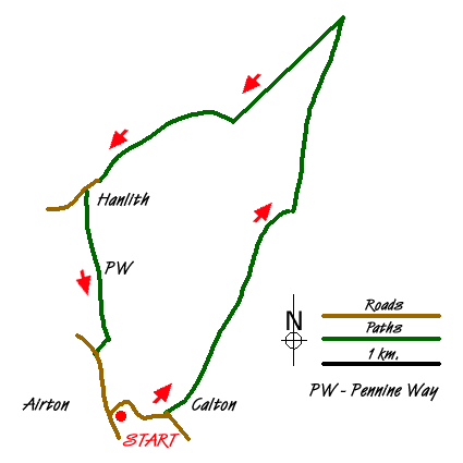
A straightforward Yorkshire Dales walk in Malhamdale from the delightful village of Airton. The route covers grass meadows and lonely peat moorland, with a final leg along the pretty river Aire via the Pennine Way.
From the picturesque triangular village green at Airton (grid ref. SD 902 591) walk downhill away from the road towards the river. Cross the bridge with its fine view of the old mills and climb through the hamlet of Calton. Where the road turns right for Winterburn keep ahead along the lane, then the track which brings you to a gate and sign to Weets Top. Follow the hairpin track and bear right to a gate. From here the path is not clear, but you need to keep at about 75 yards from the left hand wall to reach the gate in the far distant wall ahead, near the field's corner (grid ref. SD915605).
The next 2.5 miles are over access land, a clear track proceeding for 1.5 of these over the tranquil peat moors to where a signpost at the top of a rise signals you to go left. Pass through the gate, and initially keep fairly close to the wall on the right, eventually espying the track to your left after about 100 yards. Even if you fail to find this, you simply descend keeping fairly close to the wall, carefully negotiating several boggy areas (easier than they look) and following the wall as it curves left, eventually ending at the obvious gate and walled track that is Windy Pike Lane. (grid ref. SD914619)
Follow this down for a mile into Hanlith. Over to your right is the range of hills in which both Malham Cove and Gordale Scar about a mile to its right are clearly visible. Shortly after passing the splendid Hanlith Hall you reach the bridge over the river. Go through its stone stile and follow the Pennine Way for just over a mile along the Aire. On the outskirts of Airton you will see two footbridges on opposite sides of the field - you take the right hand one, climb the gravel track, turn left along the Malham road and walk back to the green.
Messaging & Social Media
Message Walking Britain and follow the latest news.

Mountain Weather
Stay safe on the mountains with detailed weather forecasts - for iOS devices or for Android devices.