Walk 1395 - printer friendly version
Broxa & Broxa Forest Walk
Author - Andy Chaplin
Length - 8.3 miles / 13.4 km
Ascent - 700 feet / 212 metres
Grade - easy/mod
Start - OS grid reference SE965944
Lat 54.336042 + Long -0.51734748
Postcode YO13 0DS (approx. location only)
This North York Moors walk explores the area lying to the north of the village of Broxa, which lies to the north-west of Scarborough. Approximately three to four kilometres of the route pass through Broxa Forest but a large part of this is at the side of the River Derwent so it never feels hemmed in by trees, as some forest walking can do.
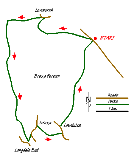
Park at the Forestry Commission parking area (grid ref. SE965945) and admire the views northwards as you boot-up before walking. Cross the road and take the path westwards that skirts the forest to Ward Hill. Just before the vehicle gate over the track head off downhill on the bridleway that drops down to Lownorth Bridge (grid ref. SE947951).
Take the road over Lownorth Beck and bear left following the path beside the beck into the Lownorth Park ex-military camp. This is now used by the Scarborough motor cycle club as a riding area. The path is clearly marked and separated from paths/tracks where motor bikes may be scrambling.
At Holm Wood cross the Harwood Dale Beck on the footbridge and keep to the right hand path that stays closest to the river Derwent. Do not take the paths that go through the Broxa forest. The path can sometimes become a number of alternatives, partly because it seems to have been churned up by bikes in wet weather. As it is always the river that you are following it is easy to maintain the overall route. At the time I walked this section there were some very impressive ant hills at the side of the path just before it left the forest.
When the forest ends the fence across the path deters further bike churning and walking becomes easier. Follow the path by the river to just before Langdale Bridge (grid ref. SE942910). If you reach the road and go over the stile then you have gone too far. Take the path on the left up Broxa Bank which joins a bridleway before reaching the road into Broxa, where you turn left.
Having walked through the village take the track off to the right (grid ref. SE945915). Having passed the farms and houses take the green lane, signposted as unsuitable for motors. This can be churned up in wet weather but there is a footpath adjacent to it as an alternative. This continues downhill to the road at the bottom (grid ref. SE954913). Again, if it is churned up towards the end an alternative is to walk through the field to the road.
Turn left along the road. A path leads from the footbridge over the stream. This leads through fields to Lowdales Farm. From here there is then a well defined track that leads north up the lush and very pretty Low Dale and Whisper Dale before climbing back into the Broxa Forest and returning to the parking place.
Messaging & Social Media
Message Walking Britain and follow the latest news.

Mountain Weather
Stay safe on the mountains with detailed weather forecasts - for iOS devices or for Android devices.