Minninglow Hill, Roystone Grange and Cardlemere Lane from Gotham
Peak District Walk
Nat Park - Peak District - Lathkill Dale High Peak
County/Area - Derbyshire
Author - Jake Robertson
Length - 5.5 miles / 8.9 km Ascent - 600 feet / 182 metres
Time - 3 hours 20 minutes Grade - easy/mod
Maps 

| Ordnance Survey Explorer OL24 | Sheet Map | 1:25k | BUY |
| Anquet OS Explorer OL24 | Digital Map | 1:25k | BUY |
| Ordnance Survey Landranger 119 | Sheet Map | 1:50k | BUY |
| Anquet OS Landranger 119 | Digital Map | 1:50k | BUY |
Walk Route Description
Click image to visit gallery of 4 images.
This is a gentle Peak District walk across the rolling pastures of the south eastern part of the limestone plateau that covers most of the 'White Peak', following the old railway line along the High Peak Trail and the beautiful Cardlemere Lane track. The distinctive summit of Minninglow, with its Neolithic burial chambers is also visited courtesy of a new concessionary path. Despite the gentle nature of the walk it is worth bearing in mind that it is almost entirely above 1000ft and in bad weather the plateau can be very bleak place indeed.
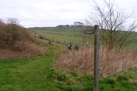
Start at the High Peak Trail car park at Gotham, just south of the A5012 at Pikehall and head east along the trail, Minninglow Hill being prominent ahead. A particularly impressive embankment is crossed after a few minutes before it contours above Minninglow Grange. When the Trail curves southwards at grid ref. SK205575 take a signposted concessionary path straight on through the fields up to Minninglow Hill summit. A short steep climb through a small band of broken limestone brings you to the summit, hidden by a ring of trees.
Although not quite the highest hill in area, Minninglow Hill (372m) is certainly one of the most prominent, its coppice being a familiar landmark from many parts of the Peak District and walking around the outside of the trees there are tremendous views in all directions. In the coppice are some excellently preserved Neolithic burial mounds and chambers, please take care not to cause unnecessary erosion or damage.
Leave the summit by the gap in the trees to the south, dropping down a field to meet a track (grid ref. SK209568). Cross the track and follow a marked footpath downhill, passing under the High Peak Trail, to Roystone Grange, a fine example of a dry limestone valley. Turn right along a track past the farm buildings following it up the valley until it meets Minninglow Lane near Roystone Cottages (grid ref. SK198576). Go left here up the lane to the junction with Parwich Lane. It is possible to cut the walk short here, the car park is only a small stroll up the road on the right, but that would miss one of the highlights.
Instead cross straight over by The Nook and head up Cardlemere Lane. This is one of the finest tracks on the limestone plateau, exceptionally beautiful and easy walking. It is a steady pull to the high point at 375m where the views stretch in all directions, Kinder Scout being visible to the north on a good day. Continue along it for another half mile then go right down another track (grid ref. SK177584), descending to rejoin the High Peak Trail just south of Upperhouse Farm. Go right again along the Trail which brings you back to the car park at Gotham after 1 ½ miles.
Other walks nearby
| Walk 1892 | Minninglow & Roystone Rocks | easy/mod | 5.8 miles |
| Walk 2503 | Robin Hood's Stride & Stanton Moor | moderate | 11.0 miles |
| Walk 2559 | Stanton Moor & The Nine Ladies Stones from Winster | moderate | 9.0 miles |
| Walk 3196 | Stanton Moor and Robin Hood's Stride from Winster | easy/mod | 7.0 miles |
| Walk 2136 | Wensley & Brightgate | easy/mod | 6.2 miles |
| Walk 1369 | Tissington Trail - Hartington to Parsley Hey | easy | 4.0 miles |
| Walk 1378 | Carsington Circular | easy | 4.5 miles |
| Walk 1379 | Carsington and Harboro Rocks | easy/mod | 5.8 miles |
| Walk 1569 | Lathkill Dale & Bradford Dale | easy/mod | 8.2 miles |
| Walk 1589 | Lathkill & Bradford Dales (short version) | easy/mod | 6.0 miles |
Recommended Books & eBooks
Walking in the Peak District - White Peak East
 Guidebook describing 42 half-day and day walks in the limestone landscapes of Derbyshire's White Peak, part of the Peak District National Park. One of two volumes, this book covers the east of the region, with potential bases including Bakewell, Eyam, Castleton, Birchover, Matlock and Wirksworth.
More information
Dark Peak Walks
 Guidebook to 40 walks in the Dark Peak area of the Peak District National Park. 35 circular routes for most abilities, from 8km to 19km, around Edale, Marsden, Fairholmes, Baslow and Castleton, including Kinder Scout and Mam Tor, and 5 longer (25km to 45km) routes highlighting the best of the Gritstone Edges, High Moorland and Deep Valleys.
More information
Messaging & Social Media
Message Walking Britain and follow the latest news.

Mountain Weather
Stay safe on the mountains with detailed weather forecasts - for iOS devices or for Android devices.