The Lambourn Downs from near Astbury
North Wessex Downs Walk
Region - North Wessex Downs
County/Area - Oxfordshire & Berkshire & Wiltshire
Author - Peter Lane
Length - 14.0 miles / 22.8 km Ascent - 700 feet / 212 metres
Time - 7 hours 40 minutes Grade - moderate
Maps 

| Ordnance Survey Explorer 170 | Sheet Map | 1:25k | BUY |
| Anquet OS Explorer 170 | Digital Map | 1:25k | BUY |
| Ordnance Survey Landranger 174 | Sheet Map | 1:50k | BUY |
| Anquet OS Landranger 174 | Digital Map | 1:50k | BUY |
Walk Route Description
Click image to visit gallery of 9 images.
This walk starts and finishes in the Valley of the Racehorse, famous for training the country's best racehorses and also takes in a rather older steed in the form of the 3,000 year old Uffington White Horse on the Ridgeway. A walk over ancient rolling chalk downs in the heart of the South of England, there can be few finer places to enjoy England's rich heritage. Wayland's Smithy (Long Barrow) is another highlight along the historic Ridgeway.
The starting point is the roadside car park on the B4000 just South of Ashbury, grid reference SU273843. Alternatively, if you wish to leave the highlights of the Ridgeway until later, park at a wide spot in the road approaching Upper Lambourn, grid reference SU314803. For the purposes of this description we will start on the Ridgeway just South of Ashbury.
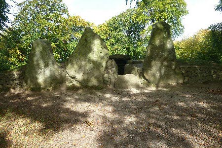
From the car park, walk East along the Ridgeway. This will pose no navigational challenge as the path is broad and well used. The first highlight after approximately 1.5km is the Long Barrow at Wayland's Smithy. This ancient burial mound dates back over 5,500 years. The entrance and initial chambers have been reconstructed for the enjoyment of visitors. Continue along the Ridgeway from the barrow and partly ascend towards the interestingly shaped Whitehorse Hill. Part way up the path on the left is a stile granting permissive access to Uffington Castle (earthwork) on the summit of Whitehorse Hill. Passing through the gap in the mound to the left of the trig point at the summit the White Horse itself is reached. Uffington is the oldest White Horse in the UK, dating back 3,000 years. Unfortunately, the full impact of this ancient monument can only be appreciated from a few miles to the North! Descending slightly from the White Horse an interesting valley called the Manger is revealed and the curious, flat topped Dragon Hill.
Return to the trig point and head left from there back to the Ridgeway and continue over the minor road at Blowingstone Hill up the hill opposite and then down to a crossroads of paths. Turn right down the green lane, past Down Barn and join a long straight section of minor road. Before the road kinks left slightly at Sevenbarrows House, take the footpath to the right past Crog Hill to the gallops. Reaching the Jockey Club gallops, turn left and follow the gallops for quite some distance until the path continues through trees. Stay left where there seems to be a choice of routes at a barn and eventually the path kinks left, passes Hangman's Stone and comes to a staggered crossroads. Here turn right and right again heading for Upper Lambourn.
Emerging opposite the quaint thatched Cruck Cottage, turn right and follow the road to the junction and turn left. The alternative start point is a couple of hundred metres on the right. Continue to the B4000 and cross straight over up Row Down. After the summit, continue to a major crossroads of paths and turn right (Northwest) to Near Down and continue on the green lane down the hill and to a crossroads of paths near Frognam Farm. Head west along the broad bridlepath and then a fifth right of way (not sign-posted) heads slightly to the right through a gap in the hedge across the field. Head for the furthest corner of the adjacent fenced field to the right and then pick up the more obvious footpath that heads to a stile opposite and climbs steadily up the bank adjacent to an ancient embankment heading towards Upper Wood.
Keep the edge of Upper Wood in view and, coming to another crossroads of paths (unfenced), head right up towards the Wood. Continue along this path past the wood to Ashdown Park. At the estate road, turn left and follow the hedge around to the right and continue past the Park to Alfred's Castle (yet another earthwork!). After exploring the earthwork, go through the kissing gate opposite and continue past Hailey Wood and, ignoring the right hand path after the wood, on to the Ridgeway. Turn right along the Ridgeway and return shortly back to the car park.
Other walks nearby
| Walk 2915 | Uffington Castle, the White Horse and Wayland's Smithy | easy/mod | 6.5 miles |
| Walk 3116 | Uffington White Horse & Wayland's Smithy | easy | 3.3 miles |
| Walk 1554 | Wayland's Smithy & Uffington Castle | easy/mod | 5.5 miles |
| Walk 3630 | Longcot & Uffington Circular | easy | 5.2 miles |
| Walk 1069 | Badbury Hill, including the Great Barn at Great Coxwell | easy | 6.0 miles |
| Walk 1061 | Faringdon, Radcot and Littleworth | easy/mod | 8.0 miles |
| Walk 1063 | Faringdon, Buckland & Pusey | easy/mod | 10.5 miles |
| Walk 1064 | Faringdon Folly, Buckland Warren and Hatford | easy/mod | 8.0 miles |
| Walk 1066 | Faringdon, Wicklesham, The Folly & Folly Park | easy | 4.0 miles |
| Walk 1079 | Faringdon, Thrupp and towards Lechlade | easy | 6.5 miles |
Recommended Books & eBooks
Walking in the North Wessex Downs
 30 walking routes exploring the North Wessex Downs Area of Outstanding Natural Beauty (AONB). The routes are between 7km to 20km through this peaceful rolling chalk landscape covering parts of four counties: Berkshire, Hampshire, Wiltshire and Oxfordshire, with descriptions to reach the highest points in each one.
More information
Messaging & Social Media
Message Walking Britain and follow the latest news.

Mountain Weather
Stay safe on the mountains with detailed weather forecasts - for iOS devices or for Android devices.