Walk 1422 - printer friendly version
Cnicht and Moelwyn Mawr Walk
Author - Peter Smyly
Length - 8.0 miles / 13 km
Ascent - 3000 feet / 909 metres
Grade - moderate
Start - OS grid reference SH631446
Lat 52.981206 + Long -4.0405441
Postcode LL48 6SR (approx. location only)
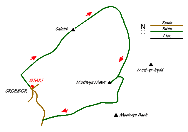
Although this Snowdonia (Eryri) walk includes only two summits when a further two could additionally be included by making reasonable route digressions, namely Moel yr Hydd and Moelwyn Bach, this is still a fine walk that is likely to span several hours. The outline of the route enables you to see Cnicht both from the south-west with its "Welsh Matterhorn" perspective as well as it's more gentle north-east flank from where it presents a very different perspective, appearing as a gentle grassy ridge with a few rocky knolls.
Start at the car park in the remote Welsh village of Croesor. If it was not for its popularity as a starting point for Cnicht, Croesor would presumably see far fewer visitors. Cnicht is waymarked from the outset at the car park as the way leads uphill along a tarmac road through the village, then up further through woodland, before emerging on to open felllside. From a navigational point of view, it would be hard to go wrong , certainly in good visibility, as you just need to follow the track up the main ridge with the objective of Cnicht seen ahead of you most of the way, drawing ever nearer, and looking more impressive, the nearer you get to it. The minor top of Yr Arddu is seen to the left with the Snowdon range beyond. A grassy section is reached in the upper stages of the ridge walk and it provides a suitable resting point before the final rocky climb to the top, about five minutes from this point. While there is no cairn to mark the top, the view more than compensates with Moelwyn Mawr starkly apparent across Cwm Croesor and the Snowdon range seen to the north-west. A number of the Moelwyn lakes can also be glimpsed afar.
Now follow the Cnicht ridge due north-east with its rocky knolls leading to more gentle grassy slopes providing much easier walking than the steep climb up to gain its summit a little earlier in the walk. Two lakes are seen, Llyn y Biswail, long and narrow, appears to the left and Llyn yr Adar, more or less circular, appears ahead. Leave the Cnicht ridge and, after about half a mile a narrow path goes off to the right. The path between here and the former Cwmorthin quarry is reliable for the most part but is indistinct in places, especially after passing the two lakes of Llynnau Diffwys. Route-finding should not be a difficulty in good visibility. After the ruined slate quarry, head for Moelwyn Mawr, with a path appearing more clearly towards the top. Llyn Croesor is passed en route, a small lake that is partly overgrown with vegetation and held back by a dam. Moel yr Hydd is seen beyond unfenced quarries to the left and if time and energy levels permit, there is an optional route variation to include this summit.
The top of Moelwyn Mawr offers a similarly picturesque view, in reverse, to the one seen earlier from the summit of Cnicht though Moelwyn Mawr is obviously the higher of the two. To the south, the view beyond the Llyn Stwlan reservoir includes Llyn Trawsfynydd with its disused power station The summit, although fairly broad and grassy has its summit cairn positioned fairly close to a steep edge. Now descend back down the ridge to where the gradient levels out and, taking care with an electric fence on the right, skirt down towards the reservoir where a path skirts the felllside to the col between Moelwyn Mawr and Moelwyn Bach, the latter looking invitingly close from this point with a path up to the left. The main impression is that of a rocky overhang but this is set apart from the summit area, as revealed further down the route back to Croesor. A path now leads across country and is marshy in places, to continue through woodland and a secondary road which leads back to the walk's start point at Croesor with a fine view of Cnicht to the right.
Messaging & Social Media
Message Walking Britain and follow the latest news.

Mountain Weather
Stay safe on the mountains with detailed weather forecasts - for iOS devices or for Android devices.