Midhurst Way - Haslemere Stn to Midhurst Bus Stn
South Downs Walk
Nat Park - South Downs
County/Area - Surrey & West Sussex
Author - John Trueman
Length - 9.5 miles / 15.4 km Ascent - 800 feet / 242 metres
Time - 5 hours 30 minutes Grade - moderate
Maps 

| Ordnance Survey Explorer OL33 | Sheet Map | 1:25k | BUY |
| Anquet OS Explorer OL33 | Digital Map | 1:25k | BUY |
| Ordnance Survey Landranger 186 | Sheet Map | 1:50k | BUY |
| Anquet OS Landranger 186 | Digital Map | 1:50k | BUY |
| Ordnance Survey Landranger 197 | Sheet Map | 1:50k | BUY |
| Anquet OS Landranger 197 | Digital Map | 1:50k | BUY |
Walk Route Description
Click image to see photo description.
The Midhurst Way starts from Haslemere Railway Station (grid ref. SU897329) and continues through Fernhurst, Henley, Easebourne and Cowdray Park to finish at Midhurst Bus Station (grid ref. SU887218). The route is for experienced walkers only. The majority of the route lies within the boundaries of the South Downs National Park and offers a variety of landscapes and points of interest.
From Haslemere Station take the 'In' entrance to the right, cross the main road and go up Longdene Rd, a gentle upward climb to the top of the hill. At a sharp left bend, go straight ahead into Hedgehog Lane and then turn right down the footpath to Sturt Farm. Cross the main A287 road and follow the pavement to the junction with the B2831. Turn right along the pavement and walk down the B2381 pavement for half a mile until you see a wooded hill and National Trust sign on your left.
Just past this on the left is the footpath which rises to Marley Common. Cross Marley Common and intersect with the lane to Kingsley Green. Follow the road south east a little way and then break off right and continue down a path in a southerly direction. This crosses the Marley Heights private road and descends the hill to Fernhurst via Vann Common. There is a wonderful view of the next wooded sandstone ridge which you cross shortly before dropping down hill gently to Midhurst and the Rother Valley. Turn left into Vann Road and continue east. Cross the A 287 and follow the one way road past the church on the left until you arrive at the cross roads almost opposite the Red Lion pub.
Turn right and follow the lane south and turn right at the next junction on a sharp bend left after about half a mile. This road loops round. At the first sharp bend to the right go straight on down the metalled track ahead of you with Verdley Place hidden behind a wooded rise to your left, bearing gently right - not straight ahead to Bridgelands Farm - to cross the bridge over the stream and turning sharply right into the restricted byway before Courts Farm. Follow the stream bank a little way and then continue south west via Dawes Highfield Copse and the westward edge of Verdley Wood until you reach the hamlet of Henley perched on the side of a long east-west sandstone hill.
Turn left into Henley Lane, go past the pub on the right - The Duke of Cumberland Arms - and walk up the slope 100 yards to the hairpin bend. The path breaks south east at this bend and follows the underside of the hill, rising gently, until you get to Verdley Farm.
Walk down the access track to the farm until you hit the lane, turn left and then right down a footpath through the wood crossing the bridleway. When you leave the wood you get a wonderful view down a gentle rise to Midhurst and, beyond, to the South Downs . The path drops straight down this farmland and enters Wick Lane. Follow Wick Lane south for half a mile and where it suddenly turns left - south east - continue along the path in a southerly direction, through the allotments, down the side of some houses until you hit a side road leading immediately to a sharp bend in the A272.
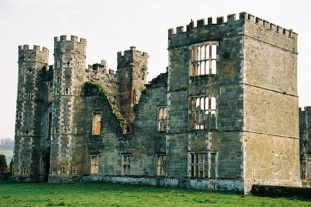
Walk along the pavement in a south easterly direction through Easebourne with The Priory and Church of St Mary to your right, and then turn immediately right into the Cowdray Estate Road . This passes after 100 yards or so the Cowdray Farm Shop and Café on the right - known locally as the Food Emporium or Fortnums on Rother - and the 100 space free car park on the left and continues as a rough unmetalled track in a south westerly direction with polo fields to the left and finally, near the banks of the serpentine River Rother, to Cowdray Castle.
Opposite the wrought iron gates to Cowdray Castle there is a bridge over the river leading to the Castle Causeway, a half-mile-long broad sandy pathway to North Street car park, the bus station and, across the main road, Capron House, the new HQ for the South Downs National Park Authority.
Other walks nearby
| Walk 1514 | Gibbet Hill & the Devil's Punch Bowl from Haslemere | easy/mod | 7.0 miles |
| Walk 2232 | Midhurst and Woolbeding | easy/mod | 6.0 miles |
| Walk 1425 | Midhurst Way - Petworth to Midhurst | easy/mod | 5.5 miles |
| Walk 3406 | The Wey & Arun Canal, Loxwood | easy | 4.5 miles |
| Walk 1976 | Noar Hill from Selborne | easy/mod | 5.0 miles |
| Walk 1869 | Thorncombe Street from Bramley | easy/mod | 6.0 miles |
| Walk 1835 | Treyford & Didling from Hooksway | easy/mod | 6.0 miles |
| Walk 3693 | Alton to Farnham using St Swithun's Way | moderate | 12.0 miles |
| Walk 1872 | Charlton, Singleton & Goodwood Circular | easy/mod | 6.5 miles |
| Walk 2422 | Butser Hill and Wether Down from Buriton | moderate | 12.5 miles |
Recommended Books & eBooks
Walks in the South Downs National Park
 Guidebook with 40 circular walks throughout the South Downs National Park, exploring the beautiful chalk hills between Eastbourne and Winchester. The walks range from under 5 miles to 11 miles, including Beachy Head and the Seven Sisters, Ditchling Beacon and hundreds of prehistoric sites. Accessible all year, but wild flowers best in spring.
More information
Messaging & Social Media
Message Walking Britain and follow the latest news.

Mountain Weather
Stay safe on the mountains with detailed weather forecasts - for iOS devices or for Android devices.