Walk 1433 - printer friendly version
Martin & Metheringham circular Walk
Author - North Kesteven Council
Length - 6.3 miles / 10.2 km
Ascent - 50 feet / 15 metres
Grade - easy
Start - OS grid reference TF128600
Lat 53.125245 + Long -0.315741
Postcode LN4 3QJ (approx. location only)
The Lincolnshire dialect word 'barff' means a hill running parallel to lower ground. A 'barff' runs most of the way from Timberland Delph, south of Martin, to Plough Hill at Branston Booths. This low ridge (some 18 metres above sea level) marks the dividing line between the dip slope of the limestone escarpment and the Witham Peat Fens. Made up of clays, silts and sands it is never more than a few miles wide. Through it the Romans cut Car Dyke, while monastic houses at Linwood and Nocton took advantage of its higher ground and fertile soil. The slopes of Blankney Barff, built in Tudor times, still have a lot of woodland and are well enclosed in stark contrast to the fenland panorama that opens to the east and beyond. In the far distance, the Wolds rear in a shadowy wave that winter occasionally crests with snow.
On this walk, from many points along the 'barff', the great Tattershall Castle is clearly visible on the southern horizon, rising from the flatness of the fens like a giant sandcastle. While to the north, Lincoln Cathedral dominates the skyline from its limestone crag.
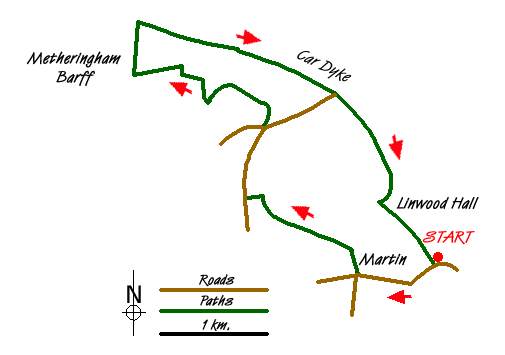
1 - From the Stepping Out Car Park, walk to the road and turn left, to walk through the village of Martin until you see Mrs Mary King's School on your right. Cross over the road.
2 - Continue out of the village along Linwood Road passing the school on your left and the cemetery on your right. As you reach a group of trees, look for a way marker leading off to your left.
3 - Turn left at the way marker, along North Moor Lane and follow the tarmac road as it becomes a grass track and winds around a small copse, passing some old farm buildings on your left. Follow the way markers passing trees on your right and cross over a wooden bridge on your right into a field. Walk along the edge of the field keeping the ancient hedgerow to your left. At a T-junction turn left and follow the track until you meet the airfield.
4 - At the junction turn right and follow the old runway, passing the Stepping Out car park until you reach a junction. In front of you is an RAF sign showing former RAF Metheringham.
5 - Cross over the road and at the metal barrier follow the track as it winds through countryside. Continue until you reach a grassy area with a way marker leading off to the right towards an area of woodland. When you reach the wood follow the way markers, keeping the wood on your left, with wonderful views to your right of the Witham valley with the former sugar beet factory dominating the skyline at Bardney.
6 - At the end of the wood take the track to the right and follow this round until you reach Metheringham Barff Farm. Pass the farm which will be to your right, follow this track and as you walk you will see a reservoir on your left. You will reach a bridge which brings you to the junction where you meet the site of the Car Dyke.
7 - Go over the Car Dyke and turn right, continuing along, keeping the Car Dyke to your right. As you walk, keep an eye out on your left for some steps going down to a carved seat as well as other small wooden sculptures celebrating the heritage and history of the land.
8 - Upon meeting a junction, continue straight ahead, sign posted "Blankney Fen". Continue along the Car Dyke, passing Car Dyke Farm on your right, until you meet a wooden gate. Cross over the stile and continue along the grassy path. This will take you over a series of stiles as the path bears left until it reaches a minor road which will take you back to the B1191. With care cross the B1191 and return to your car.
This route is from the Stepping Out series of walks produced by North Kesteven Council.
Messaging & Social Media
Message Walking Britain and follow the latest news.

Mountain Weather
Stay safe on the mountains with detailed weather forecasts - for iOS devices or for Android devices.