Walk 1438 - printer friendly version
River Witham, North Hykeham Walk
Author - North Kesteven Council
Length - 4.5 miles / 7.3 km
Ascent - 25 feet / 8 metres
Grade - easy
Start - OS grid reference SK953664
Lat 53.186168 + Long -0.575266
Postcode LN6 8ES (approx. location only)
For nearly 1,500 years between the Roman Occupation and the dissolution of the monasteries, Lincoln owed its strategic and political importance to its situation in a gap in the Lincoln Edge at the meeting of two rivers, the Till and the Witham. These rivers met in a natural lake at Brayford Pool and in about 120AD Roman engineers took advantage of this harbour to connect the colony to the River Trent via Britain's first canal, the Fossdyke Navigation. In the marshes to the south of the city lay a patchwork of watermeadows known as 'holmes'. To the northeast, recent aerial photography has revealed that Lincoln once lay close to another estuary and it is possible that Brayford Pool was directly connected to the sea. East of Brayford the Witham flowed in a wide southeasterly curve to The Wash.
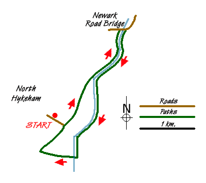
1 - From the Stepping Out car park on Fen Lane in North Hykeham, continue along Fen Lane until it reaches a public footpath.
2 - Turn left onto the footpath and follow it until it joins the River Witham.
3 - Pass through the kissing gate on your left and continue along the riverbank until you reach the Newark Road bridge.
4 - Cross over the river via the bridge and descend onto the opposite riverbank. On your left are the Bracebridge Hall fishing ponds, a relic from the time when Bracebridge Hall stood in extensive grounds.
5 - Follow this footpath all the way along the river for 3 km until you reach Meadow Lane footbridge.
6 - Turn right over this footbridge and follow the footpath right and then almost immediately left onto a public footpath.
7 - Follow this footpath for 730 metres until you reach a grassed area where you will see a waymarker directing you right along the side of a dyke.
8 - Take this footpath which brings you back to the end of Fen Lane. Turn left down Fen Lane and back to your car.
This route is from the Stepping Out series of walks produced by North Kesteven Council.
Messaging & Social Media
Message Walking Britain and follow the latest news.

Mountain Weather
Stay safe on the mountains with detailed weather forecasts - for iOS devices or for Android devices.