Walk 1459 - printer friendly version
Ben Arthur ("The Cobbler") Walk
Author - Peter Smyly
Length - 7.5 miles / 12.2 km
Ascent - 3200 feet / 970 metres
Grade - mod/hard
Start - OS grid reference NN294048
Lat 56.205122 + Long -4.7518784
Postcode G83 7AP (approx. location only)
Despite not being a Munro, Ben Arthur is one of Scotland's best known and popular mountains. It is a peak which challenges the notion that a minimum height of 3,000 feet makes a mountain worth ascending. It is not a "small hill" and, at 2,900 feet, falls not far short of Munro status. However, it is the most spectacular peak of the Arrochar Alps and it's weird, serrated outline with jagged peaks and rock buttresses dominates the skyline above Arrochar and draws attention away from some of it's higher neighbouring peaks, particularly Beinn Narnain and Beinn Ime, either or both of which can be climbed as an "out and back" from the bealach that divides Ben Arthur from Beinn Narnain.
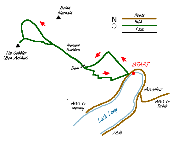
From the car park at the north-western end of Loch Long, cross the busy main road and follow the path that winds up through sparse woodland. When the path reaches a road junction, walk along the road to the left before continuing up to the right. Ben Lomond is clearly seen looking back as the view opens up a fine prospect of Loch Long below. Ben Arthur is not seen until close to emerging from the woods, but a clear path leads up the Allt a' Bhalachain valley with a stream on the left. Ben Arthur dominates the view ahead and, as you get nearer to it, ant-like figures can sometimes be seen of people already up there, particularly on the north peak which looks a little like a giant face, seen side-on. The path passes a series of giant rocks known as the Narnain Boulders. As Ben Arthur draws near at the Coire a'Bhalachain, turn right at a fork in the path to reach the bealach, passing a reedy and largely overgrown lochan, Lochan Chlaidheimh, on the right. Next, a steep series of stone steps on the left leads up to a high plateau, revealing a first glimpse of the main top.
For those with a head for heights, the airy north top should be included. The summit cairn can be reached without needing to look over the edge, but an idea of the big drops has already been gauged from seeing the top from below. The top can be reached by either a direct "route one" pathless approach or by following the path ahead before it turns left. Either way, the summit is reached by climbing over a sloping rocky section towards the top where hands as well as feet may well be needed as a steadying influence, both going up and coming back down. I prefer the latter more circuitous approach because then you get to see the spectacular overhang of the north peak with Ben Lomond in the background first. The summit reveals views in every direction. In particular, the eye is drawn across to the centre and south tops while Ben Lomond is seen beyond Loch Long and Loch Lomond. On a fine day in particular you can expect to see other people already on the centre top. Beinn Narnain dominates the view across the bealach and, despite its greater altitude, the height difference between it and Ben Arthur does not feel significant from here. A path can also clearly be seen going up the grassy slopes of Beinn Ime.
From the north top, a series of stone steps can be seen below which offer an alternative return route. Next it is down to the dip and up again to gain the main top. Some will be content to go only as far as this, but to reach the highest point involves a scramble up a rock outcrop which is not within everybody's comfort zone. Although not technically difficult, a degree of nerve is required due to the exposure after having climbed through a window in the rock. While a rope is not necessary, good body co-ordination using both hands and feet is. After passing through the window to a sloping ledge, from which there is a big drop off to the right, a walk along the ledge and a clamber up on to rocks ahead above it enables a further scramble up round to the left to gain the highest point of the rock outcrop. Some people do this manoeuvre with seemingly the greatest of ease while others are content to sit on the solid ground of the middle peak and watch others tackle the rock outcrop. In any case, on a clear day, the views are just as excellent from either vantage point.
The walk can be concluded by either reversing the outgoing route, or by way of a slight variation, by descending the path to one side of the north peak which then rejoins the main path up the valley at the fork.

Mountain Weather
Stay safe on the mountains with detailed weather forecasts - for iOS devices or for Android devices.

