Mardale Head horseshoe
Lake District Walk
Nat Park - Lake District - Lake District Far Eastern Fells
Wainwrights - Harter Fell, High Street, Kidsty Pike, Mardale Ill Bell
County/Area - Cumbria
Author - Peter Smyly
Length - 8.0 miles / 13 km Ascent - 2550 feet / 773 metres
Time - 6 hours 30 minutes Grade - moderate
Maps 

| Ordnance Survey Explorer OL5 | Sheet Map | 1:25k | BUY |
| Anquet OS Explorer OL5 | Digital Map | 1:25k | BUY |
| Ordnance Survey Landranger 90 | Sheet Map | 1:50k | BUY |
| Anquet OS Landranger 90 | Digital Map | 1:50k | BUY |
Walk Route Description
Click image to visit gallery of 6 images.
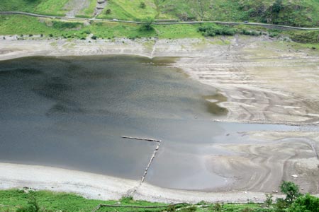
The late Lakeland author Alfred Wainwright lamented the demise of the former village of Mardale Green which disappeared under the rising waters of the then newly created Haweswater Reservoir. Even today, at times of low water level which exposes stony shorelines, the occasional dry stone wall can be seen rising above the water level. This is the setting for the start of this circular route above Mardale Head that takes in five summits. Far removed from the "honeypots" of the Lake District, it is not the easiest of places to get to, requiring a drive along narrow country roads with blind corners and occasional traffic to reach a car park at the end of Haweswater.
Rough Crag (an apt name for it) presents a ridge that is rocky and narrow in places and is apparently neglected in favour of easier terrain and this walk chooses an alternative route. Five peaks are included in the round though keen walkers could include a few more that are slightly off-route as High Raise, The Knott, Thornthwaite Crag, Adam Seat and Branstree all fall within this category. To reach each top, would involve a "there and back" before continuing with this route, though with Thornthwaite Crag there would be no need to return to High Street as a more direct approach to Mardale Ill Bell could be made.
Start at the car park and follow a path to the right that skirts the shore of the head of the lake. At times of low water level, it is easy to cross Mardale Beck. The path rises over the wooded headland of The Rigg before going down then up again as the next bit involves a clear path but a bit of a slog to gain the ridge. Fine views of the lake below are seen from different vantage points.
Kidsty Pike
This is one of the peaks on the Coast to Coast route and you may well meet some "C2Cers" on the summit or coming down the ridge towards Haweswater. Kidsty Pike is perhaps best seen from the ridge going up to High Street from where it can be seen as a shapely peak with a rocky outcrop and a steepish slope down to the Riggindale valley below. A group of "ant-like" figures at the top added a sense of scale to the view.
High Street
Next comes the Straits of Riggindale, a steady grassy slope up alongside a dry stone wall. The gradient eases off and the top of High Street is a broad grassy area that offers little incentive to linger; however, if you want to see Blea Water, the deepest tarn in the Lake District, you have to bear left away from the dry stone wall. Once the ridge coming up from Rough Crag appears on the left, Blea Water duly appears beyond it roughly circular and with grass-like gullies leading down into the depths of the tarn.
Mardale Ill Bell
From High Street, locate a path that traverses to the south-west, with the tall beacon of Thornthwaite Crag seen to the right and the lake of Windermere seen beyond Ill Bell and Froswick. The path passes a small nameless tarn on the right - barely worth a second glance on a dull day but a year earlier it looked scenic on a day of idyllic sunshine. Blea Water is not seen from this summit but a slight digression to the edge of the ridge to the left reveals a view looking down on it. It is one of the more impressive corrie tarns of the Lake District and the deepest by far.
Harter Fell
Now follow the clear rocky path down to the top of the Nan Bield Pass. Small Water is the next corrie tarn to appear below and this time, unlike with Blea Water, there is no need to leave the path for a view as it is seen from a number of vantage points both when descending to the col and on the ascent of Harter Fell. The path ascends, steep and rocky in places with Haweswater also seen below beyond Small Water. A cairn appears beyond the horizon but this is not the summit as, when you reach it, you find that the summit is a broad grassy plateau with the actual summit still further on.
To complete the route, follow the grassy ridge north-east, then south-east to Little Harter Fell and then skirt round along a very clear path to join up with the top of the Gatescarth Pass. A left turn here leads all the way back down to the car park with Haweswater seen clearly below.
Other walks nearby
| Walk 1152 | The Corpse Road and Selside Pike | moderate | 6.0 miles |
| Walk 3033 | Tarn Crag & Harrop Pike from Sadgill | moderate | 5.5 miles |
| Walk 1147 | Longsleddale and Kentmere Pike | moderate | 8.0 miles |
| Walk 1228 | Thornthwaite Beacon & High Street | moderate | 6.5 miles |
| Walk 1959 | Gray Crag and Pasture Beck from Hartsop | moderate | 5.5 miles |
| Walk 2585 | Hartsop Dodd, Stony Cove Pike, High St. & The Knott | mod/hard | 10.0 miles |
| Walk 3309 | Hartsop, Hartsop Dodd, Stony Cove Pike & Kirkstone Pass | moderate | 8.5 miles |
| Walk 2488 | Shipman Knotts & Kentmere Pike | moderate | 6.2 miles |
| Walk 1320 | Shorter Kentmere Horseshoe | mod/hard | 10.5 miles |
| Walk 2652 | Photographer's Kentmere Horseshoe | mod/hard | 13.5 miles |
Recommended Books & eBooks
Walking the Lake District Fells - Buttermere
 Part of the Walking the Lake District Fells series, this guidebook covers a wide range of routes to 32 Lakeland summits that can be climbed from the Buttermere, Lorton and Newlands valleys, with highlights including Haystacks, High Stile, Grasmoor and the fells of the Coledale Round. Suggestions for longer ridge routes are also included.
More information
Walking the Lake District Fells - Wasdale
 Part of the Walking the Lake District Fells series, this guidebook covers a wide range of routes to 25 Lakeland summits that can be climbed from the Wasdale, Eskdale and Ennerdale valleys, with highlights including Scafell Pike, Great Gable and Pillar. Suggestions for longer ridge routes are also included.
More information
Messaging & Social Media
Message Walking Britain and follow the latest news.

Mountain Weather
Stay safe on the mountains with detailed weather forecasts - for iOS devices or for Android devices.