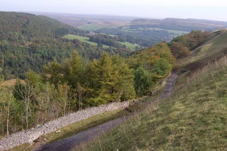
High Paradise around Arden Great Moor from Square Corner
North York Moors Walk
Nat Park - North York Moors - North York Moors West
County/Area - North Yorkshire
Author - Andy Chaplin
Length - 14.3 miles / 23.2 km Ascent - 1350 feet / 409 metres
Time - 8 hours 30 minutes Grade - moderate
Maps 

| Ordnance Survey Explorer OL26 | Sheet Map | 1:25k | BUY |
| Anquet OS Explorer OL26 | Digital Map | 1:25k | BUY |
| Ordnance Survey Landranger 100 | Sheet Map | 1:50k | BUY |
| Anquet OS Landranger 100 | Digital Map | 1:50k | BUY |
Walk Route Description
Click image to visit gallery of 3 images.
This fairly long walk is part of a series of circular walks covering the Cleveland Way. For that reason it continues down to High Paradise. Anyone who wants to reduce it by a mile or so could just go down the CW as far as Kepwick Quarry before turning towards Arden Hall.
The Cleveland Way part of this North York Moors walk gives great views from Black Hambleton off to the 'Osmotherley plain' on the west. When you leave the Cleveland Way you walk through Thorodale and Eskerdale then, as you come back via the east side of Arden Great Moor, you see the upper Ryedale, previously hidden over the top of Black Hambleton.
There is a parking for around 15 cars at Square Corner (grid ref. SE479959) and more along the roadside, although recent resurfacing has left a considerable step down to the grass verges in places. The first 5 miles follow the Cleveland Way up Black Hambleton then along the ridge past Kepwick Quarry to High Paradise. The path is easy to follow - being a track - and apart from at the start is well signposted with CW markers.
Head south from Square Corner following the Cleveland Way. There are a couple of paths off to the right for the Cycle Route 65 - carry straight on uphill. At White Gill Head there is a moors track off to the left across Arden Moor - go right on the track signposted CW. Pass the Arden Moor information board where the road comes up from Kepwick to the CW track and continue on to Steeple Cross where you go into the edge of Bolty Forest and the track becomes a path. A little after leaving the wood the CW turns off right towards High Paradise. Here you go left through the gate and take the middle of 3 paths across Dale Town Common - heading in the direction of Bilsdale Transmitter.
The path over Dale Town Common is well defined and always leading in the direction of the transmitter. When you reach the wall on your right bear left to cross the top of Stoney Gill Hole and then pick up the track that leads off right down to Arden Hall. There is a great view as you start on the track down along Thorodale.
At the signpost turn left towards Arden Hall, go left in front of it, right around the back of the cottages and follow the bridleway through the kennels and up to Nun's Well. Turn right through the gate and take the path across the field until you come down to the track that leads, on your left, up to Mount Pleasant.
Take the path to the left rather than going on the path to the right through the Mount Pleasant farm yard and climb up hill past Harker Gates. Then walk alongside and through part of Blueberry Wood. When you come to the meeting of 4 tracks take the second left which goes off uphill in the direction of the hills forming the edge of Eskerdale.
At the next meeting of tracks (grid ref. SE525918) there are some confusing path signs and removeable wire across the track straight ahead - which is the track to take. It continues along with Blueberry Wood on your left until there is a track off to the right where you continue left along the forestry track until you pass through the gate into open country. The Eskerdale Beck is down to your right. Start to climb up Eskerdale then loop back on yourself and follow the track up to the top of Harker Yates Ridge. (Editor's note - It is worth checking this section of the route on the OS 1:25000 map before you start the walk.)
At the top you come to the track leading from the gate and follow it off on the right around the edge of Eskerdale. The moors track is well defined all the way around Sun Bank although (in 2014) it had been recently re-stoned and was hard underfoot. After turning right around the Locker Beck valley turn off right on the track that heads off downhill - rather than left uphill across Arden Moor
The ruins of Dale Head are visible ahead of you. Go straight on past the track that goes off right towards the shooting boards, keeping on the main path which bends right then meets the wall and shooting boards as it comes down Locker Bank towards Wheat Beck.
Keep along the wall going down to the bridleway which crosses your path coming through a gate on the right. Follow the bridleway off on your left towards Dale Head. It is a clear path across Locker Low Moor and easier to follow than the footpath that runs above and parallel to it. Cross the beck on the bridge before Dale Head then follow the path up on the right of the fence, past the marker post and through the ruins. After Dale Head take the old farm track away from the buildings, past the new grouse butts, turn right at No 2 butt and come out at the road near Robinson?s Cross. Turn left along the road back to Square Corner.
Other walks nearby
| Walk 3718 | Scarth Wood Moor from Osmotherley | easy/mod | 6.0 miles |
| Walk 1622 | Hawnby, Bilsdale West and Wetherhouse Moors | moderate | 8.3 miles |
| Walk 3418 | Cringle Moor & the Wain Stones | easy/mod | 6.0 miles |
| Walk 1469 | Carlton Bank, Scugdale, Raisdale & Kirby Bank | moderate | 10.5 miles |
| Walk 1544 | Chop Gate, Round Hill & Stumps Cross | moderate | 10.1 miles |
| Walk 1468 | Wain Stones, Bank Foot & Bloworth Crossing | moderate | 14.3 miles |
| Walk 1524 | Cold Kirby, Rievaulx Bridge & Wass | moderate | 12.5 miles |
| Walk 3581 | Gormire Lake from Sutton Bank National Park Centre | easy/mod | 3.4 miles |
| Walk 1498 | Kilburn White Horse, Cold Kirby, Murton, & Sutton Bank | moderate | 14.0 miles |
| Walk 1920 | Rievaulx Moor from Cowhouse Bank | moderate | 9.5 miles |
Recommended Books & eBooks
Trail and Fell Running in the Yorkshire Dales
 Guidebook to 40 of the best trail and fell runs in the Yorkshire Dales National Park. Ranging from 5 to 24 miles, the graded runs start from bases such as Ribblehead, Dent, Sedbergh, Malham and Grassington and take in the region's diverse delights, from castles and waterfalls to iconic mountains such as Whernside, Ingleborough and Pen Y Ghent.
More information
The Cleveland Way Map Booklet
 Map booklet of the Cleveland Way National Trail, a 177km (110 mile) walk around the North York Moors National Park. This booklet is included with the Cicerone guidebook to the Cleveland Way and the Yorkshire Wolds Way, and shows the full route of the Cleveland Way on Ordnance Survey 1:25,000 maps.
More information
Messaging & Social Media
Message Walking Britain and follow the latest news.

Mountain Weather
Stay safe on the mountains with detailed weather forecasts - for iOS devices or for Android devices.