Hannington & Kingsclere circular
North Wessex Downs Walk
Region - North Wessex Downs
County/Area - Hampshire
Author - Peter Lane
Length - 6.0 miles / 9.8 km Ascent - 700 feet / 212 metres
Time - 3 hours 40 minutes Grade - easy
Maps 

| Ordnance Survey Explorer 144 | Sheet Map | 1:25k | BUY |
| Anquet OS Explorer 144 | Digital Map | 1:25k | BUY |
| Ordnance Survey Landranger 174 | Sheet Map | 1:50k | BUY |
| Anquet OS Landranger 174 | Digital Map | 1:50k | BUY |
Walk Route Description
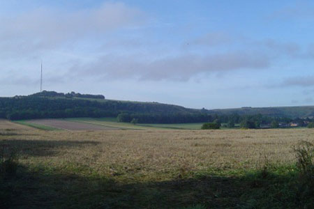
Click image to visit gallery of 9 images.
A delightful walk over the North Wessex Downs, the most elevated part of Hampshire. The rolling hills' gentle undulations belie their altitude, but still afford some wonderful views. The TV mast at Hannington is hardly ever out of sight and provides a useful reference point. The delightful village of Hannington may be explored at leisure.
The walk commences from the free car park up Anchor Road (off Swan Street) in Kingsclere, grid reference SU526585. Turn left out of the car park and walk up the hill, on a tarmac lane and emerge into a playing field. Walk half left across the field, picking up a gap in the hedge/tree-line and an enclosed footpath, latterly with a drop to the left until it reaches a broad bridlepath. Turn right here and follow this until it forks into two bridlepaths. Continue on Hollowshot Lane (the left fork) as it rises up a slope, continuing as an enclosed lane, all the way up to Rectory Lane.
Walk past Plantation Farm and follow the bend in the road as it turns right. When the lane turns left, carry straight on the metalled bridlepath. Ignore the right hand farm path on the summit of Plantation Hill and continue down to another country lane, crossing the path of a Roman Road in the process. Over the country lane go straight up the metalled bridlepath opposite until a small wood is reached. Turn right here and despite the relative level ground, you are now nearly 200 metres up on the summit of the North Wessex Downs.
Coming into Hannington, the first sign of civilisation is Michael's Field. Turn left at the end of the bridlepath and skirt Michael's Field, emerging at an attractive thatched house. Turn right here along the lane and emerge at the village green in Hannington. If seeking light refreshment, turn left and after a few hundred yards, find the Vine Public House. Otherwise, explore the green and flint church with lych gate. Once exploring is complete, take the path to the right of the church, past a wooden barn to a small wooden gate. Through the gate turn immediately right and follow the hedge to a lane. Turn right for a few yards on the lane and take the footpath on the left.
Reaching some trees, the path bends 90 ? left and then 90 degrees right. Follow the undulating path down (re-crossing the path of the Roman Road) and back up, meeting the farm track at Plantation Farm coming in from the right. Continue straight on and downhill, but don't go all the way down. Look out for a stile on the left and take the footpath going through Coronation Plantation. The path forks in a while - take the descending path through the trees. Reaching the bottom, turn left for a few yards and the emerge from the trees and head due North past the gallops. Maintain this direction after meeting up with Hollowshot Lane and after a brief climb, find yourself back in the playing field in Kingsclere. Return via Anchor Road to the car park.
Other walks nearby
| Walk 3413 | North Wessex Downs & Source of the Test | moderate | 15.0 miles |
| Walk 2063 | Watership Down and Ladle Hill from the Sydmonton Estate | easy | 4.5 miles |
| Walk 3594 | Beacon Hill near Burghclere | easy | 1.5 miles |
| Walk 3595 | Old Burghclere & Burghclere from Beacon Hill | easy/mod | 5.6 miles |
| Walk 2165 | Overton & the Harroway | easy | 4.3 miles |
| Walk 2344 | Newbury to Hungerford via Kennet & Avon Canal | easy/mod | 9.0 miles |
| Walk 1847 | Silchester Common & Calleva Atrebatum | easy/mod | 6.2 miles |
| Walk 2114 | Hampshire and Berkshire Heights | moderate | 15.0 miles |
| Walk 1901 | Around Aldermaston | easy | 5.0 miles |
| Walk 1025 | Farleigh Wallop and Ellisfield | easy/mod | 6.5 miles |
Recommended Books & eBooks
Walking Hampshire's Test Way
 Guidebook to walking the 71km (44 mile) Test Way in Hampshire from high on the chalk downs of Inkpen Beacon to the Eling Tide Mill near Southampton Water. Following the beautiful, crystal clear River Test, it passes picturesque villages and fascinating historic sites. Also includes 15 day walks to explore this lovely part of pastoral England.
More information
Walking in the North Wessex Downs
 30 walking routes exploring the North Wessex Downs Area of Outstanding Natural Beauty (AONB). The routes are between 7km to 20km through this peaceful rolling chalk landscape covering parts of four counties: Berkshire, Hampshire, Wiltshire and Oxfordshire, with descriptions to reach the highest points in each one.
More information
Messaging & Social Media
Message Walking Britain and follow the latest news.

Mountain Weather
Stay safe on the mountains with detailed weather forecasts - for iOS devices or for Android devices.