Newstead Abbey from Linby
Nottinghamshire Walk
County/Area - Nottinghamshire
Author - Wendy Vivian
Length - 5.8 miles / 9.3 km Ascent - 250 feet / 76 metres
Time - 3 hours 10 minutes Grade - easy
Maps 

| Ordnance Survey Explorer 270 | Sheet Map | 1:25k | BUY |
| Anquet OS Explorer 270 | Digital Map | 1:25k | BUY |
| Ordnance Survey Landranger 120 | Sheet Map | 1:50k | BUY |
| Anquet OS Landranger 120 | Digital Map | 1:50k | BUY |
Walk Route Description
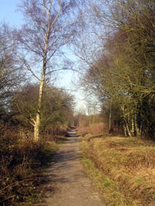
Click image to visit gallery of 9 images.
This circular walk starts from Linby, a conservation village and uses part of the dismantled Great Northern Railway line to get to Newstead Abbey, the ruins of an Augustinian Priory built by Henry II in 1170. The return to Linby is through Abbey woods and Papplewick village.
From the Top Cross in Linby village (grid ref. SK534509) walk up the hill to the traffic island. Turn right onto the path signed Linby Trail and National Cycle Network. This is along a railway cutting which follows the route of the Great Northern Railway. Here you will walk alongside a pond and see plenty of wild flowers and plants associated with railway lines. At one point on the left some of the present day railway line called the Robin Hood line which runs into Nottingham can be viewed. To the right there are large conservation areas. This straight path continues for some considerable time until some large boulders are seen ahead partially blocking the path. Here the path turns sharply to the right still signed posted the National Cycle Network alongside a woodland walk which may be visited if time allows.
The path then joins a tarmac road at one of the lodges to Newstead Abbey estate. Passing through this gate (there is no charge for walkers) follow the road until Newstead Abbey ruins come into view. The road is mostly flat apart from a couple of short climbs through glades. There are views over the country side and horses grazing in the fields on either side.
As the road descends towards Newstead Abbey the upper lake and stable block can be seen to the left followed by a waterfall and then the magnificent aspect of Newstead Abbey comes into view with the garden lake to the right. Although originally an Augustinian Priory built in 1170 it is best known as the ancestral home of Lord Byron. There is a charge to visit the museum which houses Byron memorabilia and gardens. On the grassy areas in front of the Abbey there is usually an abundance of ducks and peacocks grazing.
Follow the road round to the left between the ruins and the upper lake. Ahead is the stable block and bell tower. After passing a car park on the left and the cricket pitch to the right there is a crossroads. Turn right here and follow the tarmac road winding through the woods until a pair of wrought iron gates appears ahead. This it the entrance to another lodge, a footpath for walkers is marked to the right of the gates and follows alongside a hedge. At the other end there is a metal kissing gate to pass through before following a wide grassy path ahead with hedges on either side. At the end proceed through a metal gate and onto an unmade road which bears to the left and has large properties on either side. Follow this road called Hall Lane until a tree can be seen ahead in the middle of a small grassy area with a seat where the path meets the main road B683. Papplewick Hall can be seen immediately to the right at this junction. Turn right along the road, with a footpath, following it into Papplewick village. It bears sharply right past a row of cottages and then right where there is a wide gap after Papplewick lodge showing a sign to The Church of St James Papplewick and a public footpath signposted to Linby.
Pass through the wooden gate and follow this tarmac road in the direction of the church, which unfortunately is kept locked when not in use. Before reaching the church there is a well trodden signed path on the left through the fields to Linby At the end of the field pass through a metal gate and over a wide footbridge over the river Leen and then continue alongside a hedge bordering an arable field until it emerges onto the main road B6011 into Linby. Turn right and follow this road into the village passing the Bottom Cross on the right and the old village school. On the left hand side, next to the bus shelter is an interesting Parish Map of Linby explaining the history of the village. Continue up the hill to the Top Cross to the start of the walk.
There are no specific car parks in the village but besides the bus stops on either side of the road there are lay-bys to park in with no restrictions and no yellow lines.
Other walks nearby
| Walk 2134 | Linby and Newstead Abbey circular | easy | 5.9 miles |
| Walk 2823 | Greasley & Moorgreen Reservoir | easy | 5.9 miles |
| Walk 1460 | Hardwick Hall park | easy | 2.5 miles |
| Walk 1133 | Gunthorpe & Caythorpe from Hoveringham | easy/mod | 7.0 miles |
| Walk 2540 | The Robin Hood Way Long Distance Circular | mod/hard | 27.0 miles |
| Walk 2619 | Belper to Cromford, Amber Valley | moderate | 7.5 miles |
| Walk 2429 | Edwinstowe, Sherwood Forest & Major Oak circular | easy | 5.9 miles |
| Walk 2801 | Duffield & the Chevin | easy | 4.8 miles |
| Walk 3586 | Rolleston & Morton from Fiskerton | easy | 6.3 miles |
| Walk 2899 | Cromford Canal & Black Rocks from High Peak Junction | easy/mod | 6.8 miles |
Recommended Books & eBooks
No suggestions for this area.Messaging & Social Media
Message Walking Britain and follow the latest news.

Mountain Weather
Stay safe on the mountains with detailed weather forecasts - for iOS devices or for Android devices.