Redmire, Stanage & Ughill Moor circular
Peak District Walk
Nat Park - Peak District - Derwent Edge Sheffield
County/Area - South Yorkshire & Derbyshire
Author - Andy Chaplin
Length - 13.0 miles / 21.1 km Ascent - 1620 feet / 491 metres
Time - 8 hours 10 minutes Grade - moderate
Maps 

| Ordnance Survey Explorer OL1 | Sheet Map | 1:25k | BUY |
| Anquet OS Explorer OL1 | Digital Map | 1:25k | BUY |
| Ordnance Survey Landranger 110 | Sheet Map | 1:50k | BUY |
| Anquet OS Landranger 110 | Digital Map | 1:50k | BUY |
Walk Route Description
Click image to see photo description.
This 13 mile Peak District walk demonstrates the variation in countryside that makes Sheffield such a pleasant place from which to walk. It includes the reservoirs of Redmires and Rivelin, the views from Stanage edge, Ughill moor above the Strines and Dale Dyke reservoirs and the steep but pretty valley of the Wyming Brook.
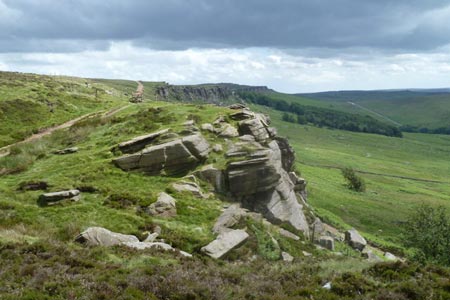
From Sheffield Parks & Countryside parking on Redmires Road (grid ref. SK257857) walk along the road then north on the track to Stanedge pole. At the pole turn right along Stanage Edge and continue all the way to the A57 by the Sheffield Country Walk. There are fine views westwards from the edge into Derbyshire.
Cross the A57 and continue on the SCW down the road past Moscar Lodge and then turn right on the green lane behind Moscar Cross Farm - still Heathy Lane - then turn left up the Stake Hill Road track over Ughill Moor to Wet Shaw Lane. The views northwards are now across the Dale Dike valley.
Turn right on the road then after half a mile turn off right on the farm track (footpath 86) on Platts Lane past Platts Farm and on to Crawshaw Farm. Before the farm turn left across the field (footpath 85 signed to Stanedge Pole) and after the gate at the top follow Platts Lane again to the right and then over the hill to Crawshaw Lodge. Cross the road (Rod Side), turning right then off on the path to the left, and continue past Surrey Farm then over the A57 again.
Go across the field and into the wood. Turn left before the bridge on the path through the wood with the river on the right. At the stone bridge climb up from the river, cross the bridge and follow the lane - Wyming Brook Drive off to your right.
Follow the lane for three quarters of a mile until it divides then take the left fork which descends gently with views of Rivelin Upper Dam on the left. As you get to the point where the lane levels out turn right through a metal kissing gate into Wyming Brook nature area - marked with an information board.
Climb up the path through the woods alongside the Wyming Brook. There are several bridges crossing the brook and the path climbs for half a mile up the rocks at the side of the brook before levelling out at the top where there are signposted routes back to the road or Wyming Brook car parking.
At Redmires Road turn right and walk back along the road for just under a mile to the car park.
Other walks nearby
| Walk 1580 | Redmires Reservoir | easy | 2.5 miles |
| Walk 2235 | Bamford & Stanage Edges | moderate | 9.9 miles |
| Walk 1479 | Burbage Moor & Redmires from near Ringinglow | easy/mod | 9.8 miles |
| Walk 2516 | Moscar, Dale Dike & Shrines Reservoirs | easy/mod | 7.0 miles |
| Walk 2629 | Stanage Edge, Redmires & Hallam Moors | easy/mod | 8.5 miles |
| Walk 1090 | Stanage Edge | moderate | 7.0 miles |
| Walk 3540 | The Derwent Edge from Cutthroat Bridge | moderate | 10.0 miles |
| Walk 1285 | Dungworth & Rod Moor | moderate | 9.4 miles |
| Walk 2548 | Stanage Edge from Hathersage | moderate | 8.5 miles |
| Walk 1579 | Damflask Reservoir | easy | 3.5 miles |
Recommended Books & eBooks
Dark Peak Walks
 Guidebook to 40 walks in the Dark Peak area of the Peak District National Park. 35 circular routes for most abilities, from 8km to 19km, around Edale, Marsden, Fairholmes, Baslow and Castleton, including Kinder Scout and Mam Tor, and 5 longer (25km to 45km) routes highlighting the best of the Gritstone Edges, High Moorland and Deep Valleys.
More information
Great Mountain Days in the Pennines
 An inspirational guidebook to 50 classic walks on the rolling Pennine landscape. The graded routes, between 6 and 13 miles in length, cover classic Pennine fells and moorland such as Whernside, Ilkley Moor and Pendle Hill; exploring the North and South Pennines, Yorkshire Dales, Howgills and Dark Peak. Many routes are also suited to fell running.
More information
Messaging & Social Media
Message Walking Britain and follow the latest news.

Mountain Weather
Stay safe on the mountains with detailed weather forecasts - for iOS devices or for Android devices.