Golden Cap from Seatown
Jurassic Coast Walk
Region - Jurassic Coast
County/Area - Dorset
Author - Lou Johnson
Length - 4.0 miles / 6.5 km Ascent - 1100 feet / 333 metres
Time - 3 hours 10 minutes Grade - easy/mod
Maps 

| Ordnance Survey Explorer 116 | Sheet Map | 1:25k | BUY |
| Anquet OS Explorer 116 | Digital Map | 1:25k | BUY |
| Ordnance Survey Landranger 193 | Sheet Map | 1:50k | BUY |
| Anquet OS Landranger 193 | Digital Map | 1:50k | BUY |
Walk Route Description
Click image to visit gallery of 6 images.
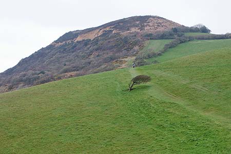
The coast of West Dorset is far different from that a few miles further east. Gone are the white cliffs replaced by a mixture of other sedimentary rocks. At 191 metres, Golden Cap is the highest sea cliff in Southern England and 30 metres higher than Beachy Head. This short half day walk starts from the small village of Seatown, which is reached down a minor road from the village of Chideock on the A35 between Lyme Regis and Bridport.
There is a small pay and display car park (Grid ref. SY420917) behind the beach with few other places to park. Before starting the walk it is a good idea to go onto the beach from where you get a good idea of the scale of the cliffs in this vicinity. From the back of the beach take the South West Coast Path west towards Golden Cap and Charmouth. Note that older maps show the original line of the path adjacent to the beach, which has been moved inland after a landslip. The path climbs steadily on a clear path with improving retrospective views along the Dorset coast towards Portland.
The going gets steeper as you near the top providing an excuse to stop and enjoy the view. There are few navigational difficulties with excellent waymarking leading you to the trig point on Golden Cap. You need to investigate the best viewpoints by exploring the summit area with the views covering a considerable length of the south coast of England. Descend from the top passing the memorial to the Earl of Antrim (Grid ref. SY405921) and continue west on the South West Coast Path with views ahead to Charmouth and beyond. After losing some height you reach a path junction. Take the right fork and descend past the remains of St Gabriel's Church and a farm on your left to reach a lane (Grid ref SY400924).
Walk along this lane to a T-junction (Grid ref. SY399930). Turn right along Muddyford Lane for about a kilometre. At the signed bridleway (Grid ref. SY407931) follow the access road to Filcombe Farm. Continue through the farm and continue with Filcombe Wood to your right. Starting to climb you arrive at a gate where the bridleways split (Grid ref. SY408924). Take the left fork and continue into Pettycrate Lane, which is followed for a gradual descent back into Seatown. Reaching the main lane through the village, turn right and the car park is at the end of the lane.
Other walks nearby
| Walk 2580 | Golden Cap & Charmouth | easy/mod | 5.0 miles |
| Walk 2391 | West Bay & Burton Cliff | easy | 4.5 miles |
| Walk 1551 | Seatown and Charmouth via Golden Cap | easy/mod | 5.0 miles |
| Walk 3629 | Eggardon Hill from Loders | moderate | 8.4 miles |
| Walk 2771 | Lyme Regis & Uplyme Circular | easy/mod | 5.5 miles |
| Walk 1550 | Charmouth & Lyme Regis Circular | easy/mod | 6.0 miles |
| Walk 3265 | Eggardon Hill from Powerstock | easy/mod | 6.3 miles |
| Walk 2565 | Littlebredy from Abbotsbury | moderate | 8.5 miles |
| Walk 2827 | Rodden & Langton Herring from Abbotsbury | easy/mod | 9.2 miles |
| Walk 2289 | Abbotsbury Castle and Chesil Beach | easy/mod | 6.0 miles |
Recommended Books & eBooks
South West Coast Path Map Booklet - St Ives to Plymouth
 Map of part of the southern section of the 630 mile (1014km) South West Coast Path National Trail. Covers the trail from St Ives to Plymouth along the west Cornwall and Devon coastline. This convenient and compact booklet of Ordnance Survey 1:25,000 maps shows the route, providing all of the mapping you need to walk the trail in either direction.
More information
South West Coast Path Map Booklet - Minehead to St Ives
 Map of the northern section of the 630 mile (1014km) South West Coast Path National Trail. Covers the trail from Minehead to St Ives along the north Devon and Cornish coastline. This convenient and compact booklet of Ordnance Survey 1:25,000 maps shows the route, providing all of the mapping you need to walk the trail in either direction.
More information
Messaging & Social Media
Message Walking Britain and follow the latest news.

Mountain Weather
Stay safe on the mountains with detailed weather forecasts - for iOS devices or for Android devices.