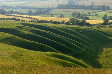
Wayland's Smithy & Uffington Castle from Woolstone
North Wessex Downs Walk
Region - North Wessex Downs
County/Area - Oxfordshire
Author - Lou Johnson
Length - 5.5 miles / 8.9 km Ascent - 700 feet / 212 metres
Time - 3 hours 30 minutes Grade - easy/mod
Maps 

| Ordnance Survey Explorer 170 | Sheet Map | 1:25k | BUY |
| Anquet OS Explorer 170 | Digital Map | 1:25k | BUY |
| Ordnance Survey Landranger 174 | Sheet Map | 1:50k | BUY |
| Anquet OS Landranger 174 | Digital Map | 1:50k | BUY |
Walk Route Description
Click image to see photo description.
This walk combines a number of interesting features of the Wessex Downs including a section of ancient pathway, a Neolithic castle and a famous landmark of the Oxfordshire countryside. The walk starts in the village of Woolstone (grid ref. SU293878), which lies to the north of the B4507 from Swindon to Wantage. Parking in the village is limited so please be mindful of residents. An alternative start is the car park at grid ref. SU273843 on the B4000 where it crosses the Ridgeway. Starting here adds just over half a mile to walk.
From Woolstone, follow Marsh Way west until the road bends sharp right. Here take the signed footpath to Knighton on your right. This leads across a meadow with the field boundary to your right to reach a track (Hardwell Lane). Turn left onto the track for a short way before taking the signed footpath on your right, which leads across fields to reach a lane (grid ref. SU282872) and the village of Knighton. Cross this lane and continue along the footpath opposite. You are now on the D'Arcy Dalton Way long distance footpath. In a short distance you reach another lane in Compton Beauchamp. Follow the road ahead for a short distance to locate the footpath once more.
The onward route to Odstone Farm is generally well trodden and the waymarking good. However a map might be a useful addition to your rucksack. Prior to Odstone Farm you join a track. Turn left (roughly south) and continue along the D'Arcy Dalton Way to reach the B4507. Cross this road with care and continue following the path/track opposite. This leads uphill to meet the Ridgeway (grid ref. SU279851). If you park on the Ridgeway you will join the route at this point.
Turn left along the Ridgeway soon passing the long barrow of Wayland's Smithy on your left. Information boards provide interesting details about this site. Continue along the Ridgeway for about a mile and a quarter to reach Whitehorse Hill (grid ref. SU300862). Uffington Castle is on your left just prior to this point. Take the footpath on the left that leads to the summit of Whitehorse Hill from where excellent views to the north can be enjoyed. This area is criss-crossed by numerous paths and precise directions are almost impossible. However from the trig point walk north and then bear slightly right towards the White Horse, which is on a north-facing slope below you.
Turn left along the edge and descend over grass to cross Dragonhill Road. As you get closer, aim for the sign. Cross the Road and bear left towards a gate. Continue downhill taking the left-hand stile. On your right is the interesting topographical feature of the Manger, which is rather pleasant rounded valley. The path leads down to a gate on the road (grid ref. SU294871). Turn right to the B4507. Go straight across and follow the lane downhill into Woolstone.
Other walks nearby
| Walk 2915 | Uffington Castle, the White Horse and Wayland's Smithy | easy/mod | 6.5 miles |
| Walk 3116 | Uffington White Horse & Wayland's Smithy | easy | 3.3 miles |
| Walk 3630 | Longcot & Uffington Circular | easy | 5.2 miles |
| Walk 2410 | Wayland's Smithy, Ashdown House and Ashbury | easy/mod | 7.5 miles |
| Walk 1419 | The Lambourn Downs from near Astbury | moderate | 14.0 miles |
| Walk 1069 | Badbury Hill, including the Great Barn at Great Coxwell | easy | 6.0 miles |
| Walk 1061 | Faringdon, Radcot and Littleworth | easy/mod | 8.0 miles |
| Walk 1063 | Faringdon, Buckland & Pusey | easy/mod | 10.5 miles |
| Walk 1064 | Faringdon Folly, Buckland Warren and Hatford | easy/mod | 8.0 miles |
| Walk 1066 | Faringdon, Wicklesham, The Folly & Folly Park | easy | 4.0 miles |
Recommended Books & eBooks
Walking in the North Wessex Downs
 30 walking routes exploring the North Wessex Downs Area of Outstanding Natural Beauty (AONB). The routes are between 7km to 20km through this peaceful rolling chalk landscape covering parts of four counties: Berkshire, Hampshire, Wiltshire and Oxfordshire, with descriptions to reach the highest points in each one.
More information
Messaging & Social Media
Message Walking Britain and follow the latest news.

Mountain Weather
Stay safe on the mountains with detailed weather forecasts - for iOS devices or for Android devices.