Kingsbarns to St Andrews - Fife Coastal Path
Fife Walk
County/Area - Fife
Author - Lou Johnson
Length - 8.0 miles / 13 km Ascent - 400 feet / 121 metres
Time - 4 hours 20 minutes Grade - easy/mod
Maps 

| Ordnance Survey Explorer 371 | Sheet Map | 1:25k | BUY |
| Anquet OS Explorer 371 | Digital Map | 1:25k | BUY |
| Ordnance Survey Landranger 59 | Sheet Map | 1:50k | BUY |
| Anquet OS Landranger 59 | Digital Map | 1:50k | BUY |
Walk Route Description
Click image to see photo description.
This linear route follows the Fife Coastal Footpath from Kingsbarns to St Andrews. If you don't have the benefit of two cars then there is a regular bus service connecting the start and end of the walk (Stagecoach route 95). It is assumed that you start in Kingsbarns as parking is easier here than in St Andrews. On completion of the walk return by bus to Kingsbarns.
From the main A917 running through Kingsbarns, follow 'Back Stile' northeast towards the sea. You soon have a view over Cambo Sands and the rocky foreshore. Turn left (with the sea on your right) and start to follow the Fife Coastal Path. The way ahead is rarely in doubt and with a virtually level route progress is generally good.
Continue past Babbet Ness staying on the path close to the sea. You turn inland along the banks of Kenly Water to just before Hillhead (grid ref. NO578140) where the Fife Coastal Path diverges off the lane to the right. Cross a footbridge over a side stream and continue to Pitmilly Mill where you cross Kenly Water to Burnside Farm, which is on your right. Shortly after the onward path bears right and leads you to a road marked with a Dovecot on OS maps (grid ref. NO566143). Turn right here and after 200 metres right again to walk down to the coast.
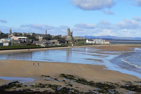
Reaching the coast turn left and continue along the Fife Coastal Footpath past Buddo Ness to reach a small stream in a deep cutting. Ford the stream and bear right to follow the path along the top of the cliffs (with Torrance Golf Course on your left) to the Rock and Spindle at Kinkel Ness. St Andrews is soon in sight and with The Castle Golf Course on your left complete the walk at East Sands. St Andrews has plenty of interest as might be expected from such a historic town and there are numerous opportunities for refreshment before returning by bus to Kingsbarns.
Other walks nearby
| Walk 1559 | Crail to Kingsbarns - Fife Coastal Path | easy/mod | 6.5 miles |
| Walk 1563 | Pittenweem to Crail - Fife Coastal Path | easy | 4.5 miles |
| Walk 1558 | Out Head & West Sands, St Andrews | easy | 3.0 miles |
| Walk 1562 | Elie to Pittenweem - Fife Coastal Path | easy | 6.0 miles |
| Walk 1962 | Lower Largo to Elie - Fife Coastal Path | easy/mod | 7.4 miles |
| Walk 3356 | Dunbar circular from John Muir Country Park | easy/mod | 8.0 miles |
| Walk 3281 | East Lomond from Craigmead | easy | 2.5 miles |
| Walk 3282 | West Lomond from Craigmead | easy/mod | 5.0 miles |
| Walk 3280 | West Lomond from near Gateside | moderate | 6.8 miles |
| Walk 1700 | Edinburgh - Royal Mile, Arthur's Seat & Princes Street | easy | 5.5 miles |
Recommended Books & eBooks
No suggestions for this area.Messaging & Social Media
Message Walking Britain and follow the latest news.

Mountain Weather
Stay safe on the mountains with detailed weather forecasts - for iOS devices or for Android devices.