Dove Valley & Biggin Dale from Hartington
Peak District Walk
Nat Park - Peak District - Dovedale Manifold Valley
County/Area - Derbyshire
Author - Lou Johnson
Length - 6.8 miles / 11.1 km Ascent - 540 feet / 164 metres
Time - 4 hours 0 minutes Grade - easy/mod
Maps 

| Ordnance Survey Explorer OL24 | Sheet Map | 1:25k | BUY |
| Anquet OS Explorer OL24 | Digital Map | 1:25k | BUY |
| Ordnance Survey Landranger 119 | Sheet Map | 1:50k | BUY |
| Anquet OS Landranger 119 | Digital Map | 1:50k | BUY |
Walk Route Description
Click image to visit gallery of 9 images.
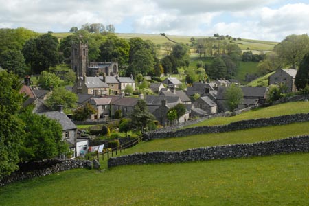
The village of Hartington is a good centre for Peak District walks with refreshments, toilets and shops readily available. Parking, except on very busy days is generally easy with on street parking around the duck pond in the village centre. There is also a car park a short way out of town on the south side of the B5045 towards Hulme End. This walk includes three dales - Beresford, Wolfscote and Biggin - together with the village of Biggin and a section across the higher land south of Hartington.
To start this Peak District walk, follow the B5054 south from the village centre. Close to the public toilets on the left hand side you will locate the signed path into Wolfscote Dale. The path is well used and easy to follow and crosses open pastures before entering woodland at the start of Beresford Dale. The path soon reaches the River Dove and you follow this well-known river south to reach a footbridge (grid ref. SK128588). Cross this footbridge and continue south to a second footbridge at the end of Beresford Lane. Cross the river here and continue alongside the river, now on your left hand side, through an open field to enter Wolfscote Dale. There is a dramatic change in scenery as you enter a steep sided valley.
The onward route is clear and progress is fast on the well maintained path. After a mile and a half you reach the point where Biggin Dale comes in from the left (grid ref. SK142569). Turn left here and make your way up steep sided Biggin Dale. The path is easy to follow but is quite rough underfoot in places. In very wet weather there may be a stream but normally the valley is dry - a typical feature of limestone country.
Eventually you reach an open area (grid ref. SK145587) where a smaller dale comes in from the right. Careful navigation is required here. Most walkers will be veering left here, instead bear right and continue up the dale which gradually gets shallower before reaching a lane at Dalehead (grid ref. SK152586). Turn left along the lane and in a short distance take the signed footpath on the right that leads across fields towards the village of Biggin. Reaching a road, turn right and then sharp left following the road north towards the village. Reaching a T-junction, turn left passing the Church on your left.
Continue along this road passing the pub on your right. Reaching a junction (grid ref. SK148595) continue straight ahead. The road bear right and on the left you will see a walled track (Highfield Lane). Follow this across the high ground. After just over a mile you reach High Cross Lane (grid ref. SK132603). Turn left, walk past Hartington Hall on your right and descend to the main road. Turn left and you are soon back in the centre of Hartington.
Other walks nearby
| Walk 1369 | Tissington Trail - Hartington to Parsley Hey | easy | 4.0 miles |
| Walk 2455 | Lum Edge & Revidge Moor | easy/mod | 6.5 miles |
| Walk 1021 | Milldale & Hall Dale | easy/mod | 5.0 miles |
| Walk 1257 | Wolfscote Dale | easy/mod | 7.5 miles |
| Walk 1709 | Milldale and Wolfscote Dale | easy/mod | 6.5 miles |
| Walk 3597 | Manifold Valley, Thor's Cave, Ecton & Wetton Hills from Alstonefield | moderate | 10.0 miles |
| Walk 3601 | Dove & Manifold Valleys | moderate | 10.0 miles |
| Walk 3709 | Sparklow, Crowdicote & Pilsbury Circular | easy/mod | 9.0 miles |
| Walk 1181 | Wetton Hill & the Manifold Valley | easy/mod | 6.5 miles |
| Walk 1653 | The Manifold Valley from Wetton | easy/mod | 7.8 miles |
Recommended Books & eBooks
Great Mountain Days in the Pennines
 An inspirational guidebook to 50 classic walks on the rolling Pennine landscape. The graded routes, between 6 and 13 miles in length, cover classic Pennine fells and moorland such as Whernside, Ilkley Moor and Pendle Hill; exploring the North and South Pennines, Yorkshire Dales, Howgills and Dark Peak. Many routes are also suited to fell running.
More information
Dark Peak Walks
 Guidebook to 40 walks in the Dark Peak area of the Peak District National Park. 35 circular routes for most abilities, from 8km to 19km, around Edale, Marsden, Fairholmes, Baslow and Castleton, including Kinder Scout and Mam Tor, and 5 longer (25km to 45km) routes highlighting the best of the Gritstone Edges, High Moorland and Deep Valleys.
More information
Messaging & Social Media
Message Walking Britain and follow the latest news.

Mountain Weather
Stay safe on the mountains with detailed weather forecasts - for iOS devices or for Android devices.