Walk 1596 - printer friendly version
Lud's Church and Roach End from Gradbach Walk
Author - Lou Johnson
Length - 4.5 miles / 7.3 km
Ascent - 700 feet / 212 metres
Grade - easy/mod
Start - OS grid reference SJ998662
Lat 53.192886 + Long -2.00445
Postcode SK17 0SU (approx. location only)
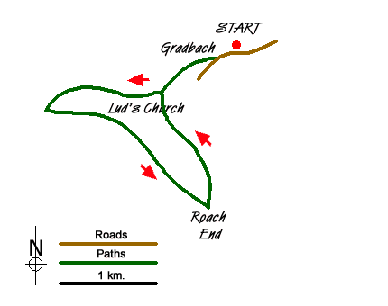
This Peak District walk explores the 'quieter' side of the Staffordshire Roaches visiting the rocky cleft of Lud's Church before exploring the moorland and woodland of Back Forest. The start is a small car park beside the River Dane on the Staffordshire/Cheshire border close to the Youth Hostel at Gradbach. On busy days parking may be problematic so an early start is recommended.
Exit the car park onto the lane and turn right. After 200 metres bear right down the access road to the Hostel, following the footpath signs through the property and alongside the river to reach a footbridge (grid ref. SJ990657). Cross the footbridge. Ignore the paths either side along the river, instead climbing up amongst the trees to reach a cross path. Turn right towards Lud's Church. The path climbs gently through the woods. A signed diversion leads you to Lud's Church which is on your right. After exploring this rocky cleft, return to the path you have just left and continue to climb soon leaving the woods and entering open country.
The path is clear and improving views over the Dane Valley towards Cheshire soon emerge. The path swings left to reach a path junction (grid ref. SJ977655). Turn left here and follow a clear rising path across the moorland (Back Forest on OS maps). You get a superb view forward to the highest ground of the Roaches with its westerly facing crags dominant. The undulating path eventually descends to a road at Roach End (grid ref. SJ995644).
Here you have the option of climbing to the summit of the Roaches by taking the clear path ahead, which leads without any navigational problems to the summit trig point at 505 metres above sea level. The views are excellent on a clear day and worth the extra effort. This option will add an extra mile and 300 feet of ascent to the walk.
To continue from Roach End, turn left and cross the stile on your left. This path leads down beside the wall (on your right) to enter the woodland above the River Dane. In places the path has been washed out and you need to be careful in descent. Almost immediately on entering the woodland you reach a path junction. Take the right hand fork. This descends through the pleasant mixed woodland to the footbridge crossed towards the start of this walk. Cross the footbridge and retrace your steps through the Hostel grounds and back to the car park.
Messaging & Social Media
Message Walking Britain and follow the latest news.

Mountain Weather
Stay safe on the mountains with detailed weather forecasts - for iOS devices or for Android devices.