Walk 1608 - printer friendly version
Calke Abbey & Robin Wood from Ticknall Walk
Author - Lou Johnson
Length - 8.0 miles / 13 km
Ascent - 400 feet / 121 metres
Grade - easy/mod
Start - OS grid reference SK350238
Lat 52.810617 + Long -1.4821952
Postcode DE73 7JG (approx. location only)
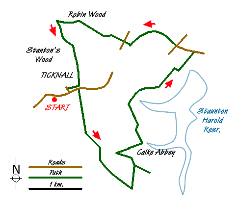
This circular walk starts from the village a few miles southwest from Melbourne on the A514. There is limited street parking but we chose to start from the Staff of Life (grid ref SK350238), a walker friendly inn where we had a late lunch at the end of the walk. You can use their car park if you let them know and provided you give them some business!
From the car park walk back to the main road and turn right through the village to reach the main entrance to Calke Abbey on your right (grid ref. SK355240). This is just before the bridge across the main road. Between the pub and the entrance to Calke Abbey you will pass the village lock-up which was where unruly inhabitants were allowed to cool off before being released.
Walk down the main drive for about one and half miles (2.5 km) passing Betty's Pond on your right, which is one of a series of ponds in the park, to reach a junction of tracks at grid ref. SK366219. Turn sharp left here and walk towards the main house. It is worth making the short detour to the church before passing in front of the main house towards the extensive outbuildings which house a café and toilets. Turn half left and follow the path heading roughly WNW to reach the point between Betty's Pond and Mere Pond (grid ref. SK363227). Turn sharp right and head east along a clear path that runs parallel to Mere Pond, which should be on your left.
The path reaches a footbridge (grid ref. SK368229) which you cross to continue on a rising path through woodland to reach open fields (grid ref. SK367233). Turn left here and continue on the well used path with views to Staunton Harold Reservoir opening up on your right. Keep straight ahead at the next path junction after which you descend into a shallow valley before climbing up to a small lane (grid ref. SK367239). Cross this and continue on the path that leads to a picnic area with its adjacent tower. Continue ahead to reach a road (grid ref. SK379247).
Turn left along this road (the B587) to a the next T- junction. Take the bridleway opposite and follow this past St. Brides to reach the A514 (grid ref. SK364250). Cross over with care and continue on the bridleway passing a trig point. Vees Wood is on your left. Entering woodland go straight ahead. Careful navigation on the next section is important and the relevant Ordnance Survey 1:25000 map is useful. The route is well used and you are aiming for the junction of paths at grid ref. SK351253 which is just after crossing a small stream and a short way south of a small pond.
At this junction turn sharp left and walk south to enter woodland once again. The bridleway is well used and soon leaves the wood to run alongside Stantons Wood on your left. Another short section through the wood leads you downhill towards the main road in Ticknall. Turn right along the main road back to the start.
It is worth noting that the boundaries of woodland do change with time. There are some new sections of tree planting in the area as part of the National Forest. As a result of this it may be that there is some disagreement between what is on maps and what you find on the ground. Careful navigation will make sure you don't go astray.
Messaging & Social Media
Message Walking Britain and follow the latest news.

Mountain Weather
Stay safe on the mountains with detailed weather forecasts - for iOS devices or for Android devices.