Meriden & Berkswell Circular Walk
Walk 1614 - Route Maps
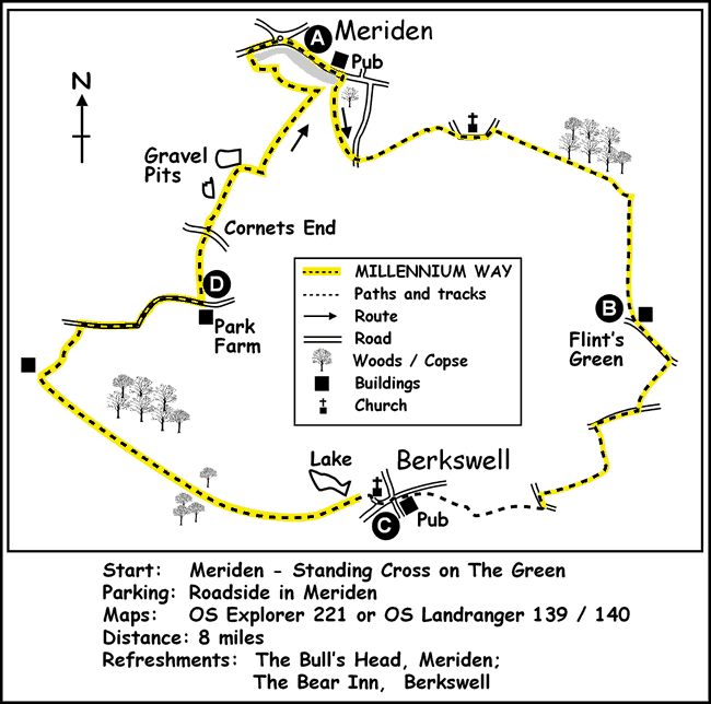
Route Map
Digital Maps - Copyright © 2011-2024. All rights reserved.
Sketch Map
Suggested Maps 

| Ordnance Survey Explorer 221 | Sheet Map | 1:25k | BUY |
| Anquet OS Explorer 221 | Digital Map | 1:25k | BUY |
| Ordnance Survey Landranger 139 | Sheet Map | 1:50k | BUY |
| Anquet OS Landranger 139 | Digital Map | 1:50k | BUY |
| Ordnance Survey Landranger 140 | Sheet Map | 1:50k | BUY |
| Anquet OS Landranger 140 | Digital Map | 1:50k | BUY |
It is recommended you take a map. The preferred scale is 1:25k.
Start Point Details
Ordnance Survey Grid Ref SP238822
Latitude 52.437259 Longitude -1.651332
Postcode CV7 7JQ
what3words start supper.badly.shelf
Walk description may contain detailed information on the start point for this walk.
Further Information
Warwickshire
The county of Warwickshire is in the English Midlands. The north and centre of the county are the areas with the highest population density. The north offers undulating countryside in contrast to the largely rural and sparsely populated south, which contains a small section of the Cotswolds. The highest point in the county, at 261 m (856 ft), is Ebrington Hill, on the border with Gloucestershire. The featured walks include sections of the Millennium Way and Heart of England Way.
Walk grading - Learn how each walk is assessed and select a walk to suit your ability and experience by going to Walk Grading Details.
Messaging & Social Media
Message Walking Britain and follow the latest news.

Mountain Weather
Stay safe on the mountains with detailed weather forecasts - for iOS devices or for Android devices.