Charleston Farm & Firle Beacon
South Downs Walk
Nat Park - South Downs
County/Area - East Sussex
Author - Lou Johnson
Length - 4.6 miles / 7.5 km Ascent - 820 feet / 248 metres
Time - 3 hours 10 minutes Grade - easy/mod
Maps 

| Ordnance Survey Explorer OL11 | Sheet Map | 1:25k | BUY |
| Anquet OS Explorer OL11 | Digital Map | 1:25k | BUY |
| Ordnance Survey Landranger 198 | Sheet Map | 1:50k | BUY |
| Anquet OS Landranger 198 | Digital Map | 1:50k | BUY |
Walk Route Description
Click image to see photo description.
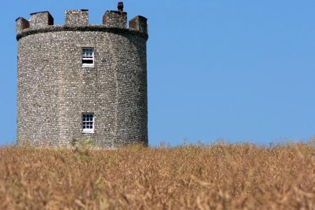
This East Sussex walk combines the wonderful views from the South Downs at Firle Beacon with the opportunity to visit Charleston Farm with its bohemian décor and associations with the Bloomsbury set. The start is the main car park in Firle village (grid ref. TQ471073). After parking follow the path across parkland aiming for Firle Tower.
Reaching a bridleway (grid ref. TQ477072)continue east through gate with the Firle Tower to your left. Continue on this bridleway passing Charleston Farm on your right. Reaching the barns, keep right and walk towards the Downs. Cross a track (grid ref. TQ492061) and continue southwards climbing onto the Downs. Reaching the top you meet the South Downs Way. Go right and continue up to the trig point on the summit of Firle Beacon (grid ref. TQ485059) to enjoy the view.
To return to Firle village continue west along the South Downs Way. After passing through a gate bear right (grid ref. TQ480059) to descend across the face of the escarpment on a bridleway. Reaching a T-junction (grid ref. TQ474068) go left and follow the track into Firle village.
Other walks nearby
| Walk 2419 | Southease, Ditchling Beacon & Lewes | mod/hard | 17.0 miles |
| Walk 1038 | Firle Beacon | moderate | 13.3 miles |
| Walk 1770 | Southease or Rodmell to Falmer | easy/mod | 6.8 miles |
| Walk 3574 | Firle Beacon & Cuckmere Valley | moderate | 10.4 miles |
| Walk 3120 | Alfriston to Rodmell by the South Downs Way | moderate | 9.0 miles |
| Walk 1015 | Ouse Valley & Beddingham Hill | moderate | 12.0 miles |
| Walk 3575 | High and Over White Horse | easy | 2.0 miles |
| Walk 1357 | The Seven Sisters from Exceat | moderate | 14.0 miles |
| Walk 2684 | Falmer to Pyecombe & Blackcap by South Downs Way | moderate | 8.8 miles |
| Walk 2227 | East Dean Circular | moderate | 11.0 miles |
Recommended Books & eBooks
Walks in the South Downs National Park
 Guidebook with 40 circular walks throughout the South Downs National Park, exploring the beautiful chalk hills between Eastbourne and Winchester. The walks range from under 5 miles to 11 miles, including Beachy Head and the Seven Sisters, Ditchling Beacon and hundreds of prehistoric sites. Accessible all year, but wild flowers best in spring.
More information
The South Downs Way
 Guidebook to walking the South Downs Way National Trail, a 100 mile (160km) route between Winchester and Eastbourne through the South Downs National Park, described in both directions over 12 stages. Easy walking on ancient and historical tracks, taking in wooded areas, delightful river valleys and pretty villages. With 1:25K OS map booklet.
More information
Messaging & Social Media
Message Walking Britain and follow the latest news.

Mountain Weather
Stay safe on the mountains with detailed weather forecasts - for iOS devices or for Android devices.