Walk 1637 - printer friendly version
Rivers Swale & Oare Walk
Author - Lou Johnson
Length - 5.0 miles / 8.1 km
Ascent - 50 feet / 15 metres
Grade - easy
Start - OS grid reference TR012647
Lat 51.3457580 + Long 0.8876589
Postcode ME13 0QD (approx. location only)
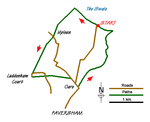
This walk explores the marshes, creeks and tideways on the south side of The Swale. On the far side of the water is the Isle of Sheppey and in season the area is an excellent place for watching birdlife. The start is the car park at grid ref. TR012647 which can easily be reached from Oare village and the centre of Faversham.
After parking follow the Saxon Shore Way west (with the Swale on your right). Reaching a disused jetty (grid ref. TR005652), turn left onto a signed bridleway. This leads through Uplees to reach a tarmac road (grid ref. TQ999643). Cross the road and follow the footpath towards Poplar Hall. You cross the access road for Howletts to join a track that leads past Poplar Hall. At grid ref. TQ994636 leave the track and take the footpath Luddenham Court with its fine church.
Just past the church take the footpath on your left. This leads east, crossing a minor road where it becomes a track to reach a junction of tracks/paths at grid ref. TQ998631. Bear right here to leave the track taking the footpath to Uplees Road on the outskirts of Oare village (grid ref. TR004630). Turn right down this road into the centre of the village.
Continue straight through the village to reach Oare Creek on your left (grid ref. TR007627). Turn left here onto Saxon Shore Way and with the water to your right walk north following the clear path alongside the creek and back to the start.
Messaging & Social Media
Message Walking Britain and follow the latest news.

Mountain Weather
Stay safe on the mountains with detailed weather forecasts - for iOS devices or for Android devices.