Beachy Head & Eastbourne from East Dean
South Downs Walk
Nat Park - South Downs
County/Area - East Sussex
Author - Lou Johnson
Length - 6.2 miles / 10.1 km Ascent - 900 feet / 273 metres
Time - 4 hours 0 minutes Grade - easy/mod
Maps 

| Ordnance Survey Explorer OL25 | Sheet Map | 1:25k | BUY |
| Anquet OS Explorer OL25 | Digital Map | 1:25k | BUY |
| Ordnance Survey Landranger 199 | Sheet Map | 1:50k | BUY |
| Anquet OS Landranger 199 | Digital Map | 1:50k | BUY |
Walk Route Description
Click image to see photo description.
This linear walk in the South Downs National Park explores a wonderful section of the East Sussex coast including Belle Tout lighthouse, Birling Gap and the spectacular cliffs at Beachy Head. The route uses sections of the South Downs Way and ends in Eastbourne. A relatively frequent bus service from Eastbourne is a convenient way of returning to the start.
The walk starts at the free car park in the middle of East Dean village (Grid ref. TV558978). You can also use the no. 12 bus service that runs between Brighton and Eastbourne fairly frequently and walk to the car park from the bus stop on the main road.
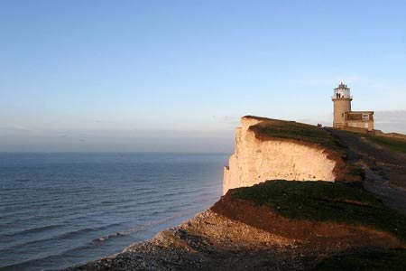
Exit the car park and walk south along Gilbert's Drive towards the coast. Just before this road bends sharp right, continue ahead onto the signed bridleway. This leads past Birling Farm on your right. Ignore the first bridleway on your left and continue to the next junction of bridleways (grid ref. TV559969) where you go right. Continue past Cornish Farm walking almost due south to reach a road (grid ref. TV564956). Cross the road to a junction of paths. Turn left. Belle Tout Lighthouse is on your right as the path follows the road to reach the cliff tops.
Turn left along the South Downs Way National Trail, with the sea to your right. This well used path is followed to Beachy Head where there are some wonderful views down to the lighthouse and along the high chalk cliffs. After enjoying the view continue along the clear path until you are near the trig point on your left. This route leaves the South Downs Way here and turns right onto the Weald Way. The path descends quite steeply towards the coast with path returning to the cliff top until you reach the outskirts of Eastbourne at Holywell.
The path joins the B2103 and South Downs Way (grid ref. TV600971). Turn right along the B2103 for approximately 250 metres until you can veer right and down to the seafront once again. You can now enjoy a leisurely stroll along the promenade continuing as far as Eastbourne Pier. All that remains is to catch the bus back to the start.
Other walks nearby
| Walk 1357 | The Seven Sisters from Exceat | moderate | 14.0 miles |
| Walk 3516 | Eastbourne to Alfriston by the South Downs Way | mod/hard | 12.5 miles |
| Walk 3575 | High and Over White Horse | easy | 2.0 miles |
| Walk 3120 | Alfriston to Rodmell by the South Downs Way | moderate | 9.0 miles |
| Walk 3574 | Firle Beacon & Cuckmere Valley | moderate | 10.4 miles |
| Walk 1015 | Ouse Valley & Beddingham Hill | moderate | 12.0 miles |
| Walk 1633 | Charleston Farm & Firle Beacon | easy/mod | 4.6 miles |
| Walk 2419 | Southease, Ditchling Beacon & Lewes | mod/hard | 17.0 miles |
| Walk 1038 | Firle Beacon | moderate | 13.3 miles |
| Walk 1770 | Southease or Rodmell to Falmer | easy/mod | 6.8 miles |
Recommended Books & eBooks
The South Downs Way
 Guidebook to walking the South Downs Way National Trail, a 100 mile (160km) route between Winchester and Eastbourne through the South Downs National Park, described in both directions over 12 stages. Easy walking on ancient and historical tracks, taking in wooded areas, delightful river valleys and pretty villages. With 1:25K OS map booklet.
More information
Walks in the South Downs National Park
 Guidebook with 40 circular walks throughout the South Downs National Park, exploring the beautiful chalk hills between Eastbourne and Winchester. The walks range from under 5 miles to 11 miles, including Beachy Head and the Seven Sisters, Ditchling Beacon and hundreds of prehistoric sites. Accessible all year, but wild flowers best in spring.
More information
Messaging & Social Media
Message Walking Britain and follow the latest news.

Mountain Weather
Stay safe on the mountains with detailed weather forecasts - for iOS devices or for Android devices.