Church End & Erwarton from Shotley Gate
Suffolk Coasts and Heaths Walk
Region - Suffolk Coasts and Heaths
County/Area - Suffolk
Author - Lou Johnson
Length - 6.0 miles / 9.8 km Ascent - 200 feet / 61 metres
Time - 3 hours 10 minutes Grade - easy
Maps 

| Ordnance Survey Explorer 197 | Sheet Map | 1:25k | BUY |
| Anquet OS Explorer 197 | Digital Map | 1:25k | BUY |
| Ordnance Survey Landranger 169 | Sheet Map | 1:50k | BUY |
| Anquet OS Landranger 169 | Digital Map | 1:50k | BUY |
Walk Route Description
Click image to see photo description.
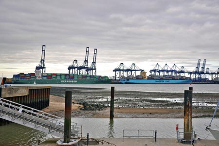
This Suffolk walk starts from Shotley Gate at the confluence of the Stour and Orwell rivers. The route offers and interesting insight into the operation of the ports of Felixstowe and Harwich together with a lengthy section of the Stour and Orwell Walk. The route also ventures inland to Church End and passes Erwarton Hall.
The start is the seafront in Shotley Gate (grid ref. TM245336) or as near as you get if parking is problematic. At Shotley Pier face the sea and turn left passing a Martello Tower on your left, Continue past the marina keeping to the shoreline of the River Orwell. With Shotley Marshes on your left walk north ignoring the footpath on the left to Over Hall. Continue north to the next junction at Crane's Hill (grid ref. TM245360) where you leave the Stour and Orwell Walk and head inland along a track.
Reaching a junction of tracks, go left towards the church at Church End. At the crossroads in the centre of the village go straight ahead down a minor road (Shotley Walk) to reach Shotley Hall. Turn left down a track opposite the Hall to take the first footpath on the right. Initially the field boundary is on your left but the path switches to the other side of the boundary and continues to a road (B1456).
Bear left along the road to a junction. Cross the road and take the minor road (Erwarton Walk) to a T-junction close to Erwarton Hall. Turn left and then immediately after Erwarton Hall Farm turn right down a track. You are now on another section of the Stour and Orwell Walk. Continue passing a reservoir on your right to reach a junction of tracks. The Stour and Orwell Walk goes left here. You turn right and right again (grid ref. TM224347) following a track down to the River Stour near Waterhouse Creek. Turn left along the shoreline path and continue past Rose Farm Cottages. The path leads back to the pier at Shotley Gate.
Other walks nearby
| Walk 2017 | Pin Mill to Shotley Gate | easy | 5.5 miles |
| Walk 1639 | Erwarton, Church End & River Orwell from Pin Mill | easy/mod | 8.0 miles |
| Walk 3642 | Shotley Gate & Ewarton from Chelmondiston | moderate | 10.6 miles |
| Walk 3267 | Ramsholt, River Deben and Shottisham Circular | easy/mod | 9.2 miles |
| Walk 2374 | Freston Circular | easy/mod | 6.6 miles |
| Walk 2096 | Alton Water, Stutton & Tattingstone | easy | 5.5 miles |
| Walk 2149 | Circuit of Alton Water | easy/mod | 7.6 miles |
| Walk 2366 | The Naze from Walton-on-the-Naze | easy | 6.0 miles |
| Walk 3658 | Manningtree, Flatford Mill and Dedham | easy/mod | 7.1 miles |
| Walk 3660 | Stour Valley & Dedham from Flatford Mill | easy | 3.5 miles |
Recommended Books & eBooks
Suffolk Coast and Heath Walks
 Guidebook to three long-distance routes exploring the varied landscapes of the Suffolk Coast and Heaths AONB. The Suffolk Coast Path covers 55 to 60 miles from Lowestoft to Felixstowe. The Stour and Orwell Walk is 40 miles from Felixstowe to Cattawade near Manningtree, while the Sandlings Walk is 59 miles from Ipswich to Southwold.
More information
Messaging & Social Media
Message Walking Britain and follow the latest news.

Mountain Weather
Stay safe on the mountains with detailed weather forecasts - for iOS devices or for Android devices.