Spurn Head from Kilnsea
East Yorkshire Walk
County/Area - East Yorkshire
Author - Lou Johnson
Length - 8.5 miles / 13.8 km Ascent - 150 feet / 45 metres
Time - 4 hours 20 minutes Grade - easy/mod
Maps 

| Ordnance Survey Explorer 292 | Sheet Map | 1:25k | BUY |
| Anquet OS Explorer 292 | Digital Map | 1:25k | BUY |
| Ordnance Survey Landranger 113 | Sheet Map | 1:50k | BUY |
| Anquet OS Landranger 113 | Digital Map | 1:50k | BUY |
| Ordnance Survey Landranger 107 | Sheet Map | 1:50k | BUY |
| Anquet OS Landranger 107 | Digital Map | 1:50k | BUY |
Walk Route Description
Click image to see photo description.
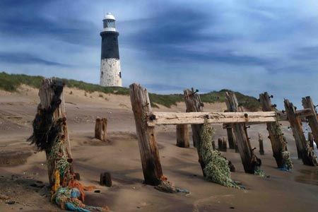
Spurn Head or Spurn Point is a narrow sand spit on the tip of the coast of East Yorkshire reaching into the North Sea at the mouth of the Humber estuary. It is over 3 miles long stretching almost halfway across the estuary at this point. At its narrowest point it is about 50 metres wide. The southern tip is home to a RNLI lifeboat station and a disused lighthouse.
The start of the walk is the car park on the east coast at Kilnsea (grid ref. TA417158). After parking walk west along the road, passing the Visitor Centre and continuing to the west shoreline of Spurn Head, where there is another car park. Here turn left along the shore following a rough track south. This leads past Spurn Bird Observatory and onto the spit. Little remains to be described except continue along the spit until you reach the southernmost tip where it is worth walking around the head with its lifeboat station and lighthouse.
There is no choice of return route so retrace your steps north to the start.
Other walks nearby
| Walk 2070 | Tetney Lock and the Humber Estuary | easy | 4.5 miles |
| Walk 2318 | New Waltham Circular | easy | 4.5 miles |
| Walk 2722 | Covenham St. Bartholomew & the Reservoir | easy | 4.8 miles |
| Walk 1984 | Nettleton Beck from Rothwell | easy/mod | 8.4 miles |
| Walk 1914 | Louth, South Elkington, Hallington & Raithby | easy/mod | 7.5 miles |
| Walk 1511 | Caistor and Nettleton | easy | 4.0 miles |
| Walk 1129 | Tathwell & Haugham circular | easy | 5.5 miles |
| Walk 3224 | Tealby, Walesby, Claxby & Normanby-le-Wold | moderate | 10.5 miles |
| Walk 1712 | Tealby & Risby circular | easy | 3.5 miles |
| Walk 1817 | Walesby from Tealby circular | easy | 5.0 miles |
Recommended Books & eBooks
No suggestions for this area.Messaging & Social Media
Message Walking Britain and follow the latest news.

Mountain Weather
Stay safe on the mountains with detailed weather forecasts - for iOS devices or for Android devices.