Walk 1670 - printer friendly version
Hazelhurst Fell, Fair Snape Fell and Parlick Walk
Author - Lou Johnson
Length - 11.0 miles / 17.9 km
Ascent - 1100 feet / 333 metres
Grade - moderate
Start - OS grid reference SD546455
Lat 53.9036620 + Long -2.6924817
Postcode PR3 1UP (approx. location only)
The Forest of Bowland offers many opportunities for walking and this circuit of the high ground at the western end of the area provides many excellent views, some moorland walking and the interesting hamlet of Bleasdale with its fine church. A good sense of directions is required for some sections of this walk and you need to take along the relevant OS 1:25000 Explorer series map. It is not a route recommended for inexperienced walkers. Ample food and water is also needed as there are no opportunities for refreshment during the walk.
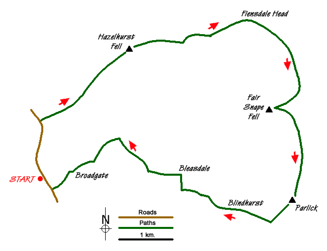
The start is the small car park on Delph Lane (grid ref. SD546455). After parking exit the car park and turn left along Delph Lane for just over half a mile to reach a track on the right hand side leading to Stang Yule (grid ref. SD545465). Turn up this track and in a short way turn left at a junction. This leads to open country. Turn right onto a track heading ENE rising across the moorland. The track eventually peters out and becomes a feint path. If you lose the path then follow sheep tracks maintaining the same general direction roughly walking parallel to the northern boundary of Fell Plantation on your right aiming for the northern corner of the plantation at grid ref. SD556472).
Join the track at this corner and follow it for a short way before veering off north-east to the summit of Hazelhurst Fell (grid ref. SD563480). From the summit, head just north of east to follow Calder Dyke (grid ref. SD572482) east to join a track. Stay with this track across the northern side of Winny Bank. The track continues east towards Fiensdale Head (grid ref SD589485) where you meet a path trending northeast down into Fiensdale. Cross this path maintaining an easterly direction to meet with a clearer path heading south-east. Turn right onto this and continue to a cairn at grid ref. SD597472). The path swings southwest shortly afterwards and makes a beeline for the summit of Fair Snape Fell (grid ref. SD591468). The views from here include much of the return route which crosses the countryside far below.
The navigational problems are now behind you and route finding becomes much easier. From Fair Snape Fell follow the clear path along the edge in a south-easterly direction. The path swings round to head south and you soon reach the final summit of the route - Parlick (grid ref. SD595450). From this summit you have a steep descent over grass following the fence (which should be on your left) in a south-westerly direction. At the bottom of the fell, take the lower path west to Blindhurst, continuing along a track and then paths to Bleasdale School (grid ref. SD573452). Turn right up the lane to Bleasdale Church. Follow the track on the left opposite the church passing Admarsh Barn to Brooks. Continue north-west on an improving track to reach a junction (grid ref. SD561462). Keep left here and continue through Broadgate Wood to Broadgate Farm and onto Delph Lane near High Moor. Turn right up Delph Lane and the car park is a short way along on the left hand side.
Messaging & Social Media
Message Walking Britain and follow the latest news.

Mountain Weather
Stay safe on the mountains with detailed weather forecasts - for iOS devices or for Android devices.