Netherbeck Horseshoe - Middle Fell, Steeple & Red Pike from Wasdale Head
Lake District Walk
Nat Park - Lake District - Lake District Western Fells
Wainwrights - Haycock, Middle Fell, Red Pike (Wasdale), Scoat Fell, Seatallan, Steeple, Yewbarrow
County/Area - Cumbria
Author - Lou Johnson
Length - 12.5 miles / 20.3 km Ascent - 5000 feet / 1515 metres
Time - 11 hours 20 minutes Grade - mod/hard
Maps 

| Ordnance Survey Explorer OL4 | Sheet Map | 1:25k | BUY |
| Anquet OS Explorer OL4 | Digital Map | 1:25k | BUY |
| Ordnance Survey Explorer OL6 | Sheet Map | 1:25k | BUY |
| Anquet OS Explorer OL6 | Digital Map | 1:25k | BUY |
| Ordnance Survey Landranger 89 | Sheet Map | 1:50k | BUY |
| Anquet OS Landranger 89 | Digital Map | 1:50k | BUY |
Walk Route Description
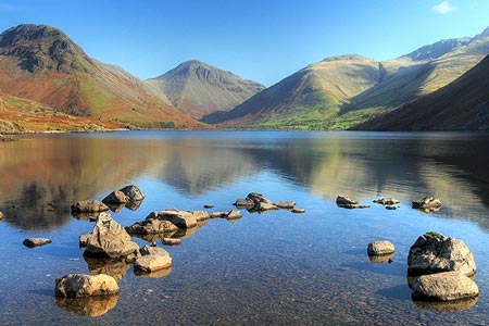
Click image to see photo description.
This is a demanding Lake District walk including seven 'tops' in the Western Fells of Lakeland. Generally the route follows clear paths certainly once Steeple has been reached. However the first half of the walk sees relatively few walkers and some navigational skills may be required in periods of poor visibility.
From the car park (grid ref. NY167068), head Southwest along the Wasdale Road passing over Netherbeck Bridge. Continue along the road, with some excellent retrospective views to the Scafells, until you reach a road junction (grid ref. NY151053). Turn right here and follow the road until just short of Greendale. Take the wide grassy footpath on your right that leads eventually up to Greendale Tarn. Gaining height you eventually reach a point where the path forks as the gorge begins to narrow. Here go right and start the ascent of Middle Fell.
The onward path, rather feint in places, leads you onto the broad summit ridge with a large cairn providing evidence of the highest spot. The view from here is excellent and apart from Steeple the remaining walk can be seen very clearly. Leave Middle Fell's summit in a northerly direction and drop down to a rather uninteresting section of the route. Crossing a wide hause the next objective, Seatallan, is on your right. The ground on this section can be wet underfoot but is relatively short-lived as you gain drier land as you climb onto the eastern flank of Seatallan.
Reaching a cairn on Seatallan's shoulder, bear left and complete the ascent of this relatively un-walked hill. The summit has both a trig point and a cairn - it's your decision which signifies the highest point. We now retrace our steps descending to the Pots of Ashness and then following a feint path that leads to Gowder Crag. The best way of tackling this obstruction is to bear right and make your way uphill choosing the best line of approach. You then reach a bank of scree and there is no option but to head upwards until you reach grass. Reaching a cairn the path continues to Haycock's summit cairn.
You are now entering busier walking territory and the next objective is Scoat Fell. The way is obvious with a wall shadowing the path. Just before reaching a cairn on the rise up to Scoat Fell's summit turn left and head for Steeple. Return to the main ridge and continue to Scoat Fell's summit cairn. To continue head southeast towards Red Pike following a path that turns right a short way down the descent to Pillar. There is a path that avoids Red Pike's summit but it is worth heading for the summit cairn with its fine position on the rim of Mosedale.
The descent from Red Pike crosses easier ground and you soon reach a col at Dore Head. Ahead lies Stirrup Crag, which is the last obstacle to completing the walk. The route is easy to follow and there are some sections that require simple scrambling but eventually you will reach the top and be able to stride out for Yewbarrow's summit cairn. The descent is initially straightforward but then needs care. The path reaches a dip just before the rocks of Bell Rib. Here you need to drop to the right entering a stony gully. The way down is initially not pleasant but does reach easier ground to become a good path across the fellside. Reaching a wall, cross the stile and descend to the small car park probably feeling rather tired!
Other walks nearby
| Walk 1126 | Mosedale Horseshoe | hard | 11.5 miles |
| Walk 1246 | Black Sail Pass & Beck Head | moderate | 5.5 miles |
| Walk 2034 | Scafell from Wasdale Head | hard | 6.5 miles |
| Walk 2800 | The Scafells via Piers Gill from Wasdale Head | mod/hard | 7.5 miles |
| Walk 2900 | Pillar (by the High Level Path) from Wasdale | mod/hard | 8.0 miles |
| Walk 2718 | The Scafells from Wasdale Head | mod/hard | 9.0 miles |
| Walk 1303 | Buckbarrow, Seatallan & Middle Fell from Loweswater | moderate | 7.0 miles |
| Walk 3489 | Scale Bridge & Low Wood from Greendale | easy | 5.2 miles |
| Walk 3485 | High Birkhow & Low Wood from Wast Water | easy | 4.2 miles |
| Walk 2355 | Blea Tarn & Eskdale Green | easy/mod | 6.5 miles |
Recommended Books & eBooks
Lake District: High Level and Fell Walks
 This guidebook describes 30 graded fell walks on the ridges and high peaks of the English Lake District, the UK's most popular national park. Reaching some of England's finest and highest mountain scenery, this guide leads readers to classic horseshoes and traditional ascents as well as lesser-known routes to quieter summits.
More information
Walking the Lake District Fells - Mardale and the Far East
 Part of the Walking the Lake District Fells series, this guidebook covers a wide range of routes to 36 Lakeland summits that can be climbed from the Ullswater, Haweswater, Troutbeck, Kentmere and Longsleddale valleys, with highlights including High Street, Place Fell and the Kentmere fells. Suggestions for longer ridge routes are also included.
More information
Messaging & Social Media
Message Walking Britain and follow the latest news.

Mountain Weather
Stay safe on the mountains with detailed weather forecasts - for iOS devices or for Android devices.