Walk 1726 - printer friendly version
Weston Corbett from Upton Grey Walk
Author - Lou Johnson
Length - 5.6 miles / 9.1 km
Ascent - 500 feet / 152 metres
Grade - easy
Start - OS grid reference SU696484
Lat 51.2305530 + Long -1.0045700
Postcode RG25 2RD (approx. location only)
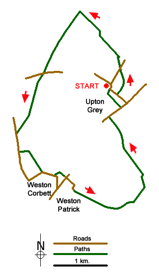
This pleasant walk through the Hampshire countryside starts from the attractive village of Upton Grey with its many listed buildings. On street parking is available close to the Parish Church (grid ref. SU696484). However, do be considerate of residents when parking. The walk starts by heading down the lane with the church on your left. Just past the church take the footpath on your left. This leads around the left-hand edge of a field, passing Manor Farm to your left, to join a farm track and the exit onto a lane (grid ref. SU698487). Cross the lane and take the continuing path half right across two fields to join Cleves Lane (SU697489).
Bear right and locate the signed bridleway (a well-made track) that heads roughly north. After just over half a mile you reach a T-junction of tracks (grid ref. SU691496). Turn left and continue along the clear track. Keep straight ahead when the clear track turns sharp right towards Pudding Copse and continue to reach a lane (grid ref. SU686487).
Cross the lane and continue in the same direction on another clear track. This leads through Dower Farm, passes The Dower House on your left and reaches a lane (grid ref. SU682477). Turn left along the lane. After 300 metres turn left on the signed path (access drive to Reeds House Farm) and just before the farm buildings turn right across the field aiming for the house on the far boundary. Go to the left on this house to reach a lane (grid ref. SU685471). Reaching a small wood on your left, take the footpath that skirts the edge of the wood into a field. Bear right keeping the field boundary on your right to reach a road (grid ref. SU689470).
Cross the road and take the residential road opposite. This leads towards Weston Patrick church, which is on your left. Follow the road as it bends right and then left and continue through Manor Farm to join a clear track (grid ref. SU691468). Continue straight ahead at the first junction and follow a clear path into the woodland of Little Park Copse. Ignore the cross track and continue ahead on a reasonably clear path through Privett Copse to exit the woods (grid ref. SU701468).
Just over 100 yards after leaving Privett Copse, take the signed path on your left (grid ref. SU702469). This leads along the edge of a large field. Continue along the hedge to first corner (grid ref. SU699474) and bear left through a small wood. Ignore the path going left (grid ref. SU698475) and continue by bearing right following the edge of the small wood. The path leads through fields to reach Weston Road (grid ref. SU696480).
Turn right along Weston Road with houses to your left. After 250 yards turn left up a driveway (signed as a footpath). Where the driveway bears left to a house, continue straight ahead on a path across a field to reach a lane (grid ref. SU696483). Turn right along the lane and you are soon back at the start of the walk.
Messaging & Social Media
Message Walking Britain and follow the latest news.

Mountain Weather
Stay safe on the mountains with detailed weather forecasts - for iOS devices or for Android devices.