Walk 1737 - printer friendly version
West Berkshire downs Walk
Author - Lou Johnson
Length - 7.4 miles / 12 km
Ascent - 750 feet / 227 metres
Grade - easy/mod
Start - OS grid reference SU361770
Lat 51.4908 + Long -1.4814326
Postcode RG17 7HH (approx. location only)
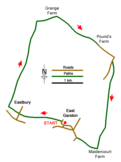
This circular walk explores the rolling downs of West Berkshire in the area north of the River Lambourn in what is often described as the "Valley of Racehorses". The route follows paths and tracks across the countryside passing some of the gallops and stables where the horses are trained. The route starts from the small village of East Garston where limited on-road parking can be found Station Road close to All Saint's Church (grid ref. SU361770).
After parking locate the entrance driveway to the parish church and take the enclosed signed footpath running west. This is part of the Lambourn Valley Way. Follow this path through fields to reach a flight of steps leading down to a road in the village of Eastbury (grid ref. SU349772). Cross the roads and walk up the steps opposite to follow and enclosed path for 350 metres as far as a path 'cross-roads'. Turn right and follow a clear track which undulates across the downs for about three kilometres. After passing some gallops and just past a row of conifers, bear path out of the field to follow a path through a small wood.
Leaving the woodland (grid ref. SU354800), turn right along a track to reach Grange Farm. Once clear of the farm buildings, continue ahead ignoring the byway on the right. Almost immediately the track forks (grid ref. SU360800). Take the right fork along a restricted byway and continue straight ahead to reach Pound's Farm (grid ref. SU372793). Go past the farm, which is on your left, to join a surfaced lane which is followed for half a kilometre to a junction by Oakedge Copse (grid ref. SU377789).
Follow the road as it bends to the right. After 100 metres, near the end of an area of woodland, turn left onto a signed track. Continue on this track for just under three kilometres to reach Maidencourt Farm. Just after the farm you reach the River Lambourn. Just before the river, take the footpath on the right (grid ref. SU372759) and follow the riverside path, the Lambourn Valley Way, to a road in East Garston (grid ref. SU366764). Walk straight ahead along Front Street into the village with its many thatched cottages. Stay on Front Street which eventually becomes Station Road. Continue ahead to return to the start.
Messaging & Social Media
Message Walking Britain and follow the latest news.

Mountain Weather
Stay safe on the mountains with detailed weather forecasts - for iOS devices or for Android devices.