Walk 1740 - printer friendly version
Attermire Scar & Victoria Cave Walk
Author - Lou Johnson
Length - 5.1 miles / 8.3 km
Ascent - 1000 feet / 303 metres
Grade - easy/mod
Start - OS grid reference SD819637
Lat 54.068914 + Long -2.2780687
Postcode BD24 9JD (approx. location only)
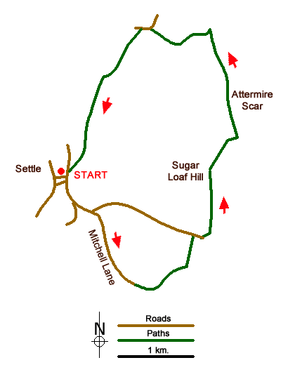
This Yorkshire Dales walk starts from the market town of Settle. The route explores the fine limestone scenery lying to the east of the town with Attermire Scar and Victoria Cave the main highlights of the walk. Several parking options are available in Settle including a pay and display car park on Whitefriars Court (grid ref. SD819637). After parking walk to the Market Square which lies on the B6480 which forms the main road through the town.
To start the walk, follow the signed road to "Airton, Gargrave and Barnoldswick". This takes you along High Street. Bear half left into Victoria Street and climb this partly cobbles road to reach a junction (grid ref. SD823633). Bear half left following the road to Airton climbing quite steeply up Albert Hill. Reaching a fork in the road just before the end of the 30 m.p.h. sign, go half right into Mitchell Lane (signed as a no-through road). This lane, a section of Pennine Bridleway, climbs steadily offering an excellent retrospective view across Settle. After a kilometre the road starts to descend (grid ref. SD828624). Bear half left onto a track - Lambert Lane - signed as the Pennine Bridleway and follow this for a further kilometre to reach the Settle to Airton Road (grid ref. SD834630).
Turn right and after 50 metres turn left onto Stockdale Lane (again signed as the Pennine Bridleway). Where Stockdale Lane turns sharp right, cross the ladder stile in front of you and continue ahead, with wall to your right, to cross the crest of Sugar Loaf Hill. The view ahead is spectacular with limestone country at its best. Warrendale Knotts with its limestone scars and caves lies ahead with the valley below Attermire Scar lying to its immediate right.
Continue through the left-hand gate and follow a grassy path to the fingerpost by the wall. Cross the stile and go right along the wall soon heading left into the valley below Attermire Scar (grid ref. SD839641). Walk north along the path at the foot of the Scar to reach Victoria Cave on your right (grid ref. SD837650). A narrow path leads up to the cave and the short detour is worth the extra effort. After visiting the cave, return to the main path and continue north to go through a kissing gate. After 25 metres turn left through a large gate (grid ref. SD836653) and follow the track in a westerly direction. Follow the track down to a road (grid ref. SD829653). Turn left along the road and immediately take the signed bridleway on the left. The bridleway descends steadily back to Settle Market Place.
Messaging & Social Media
Message Walking Britain and follow the latest news.

Mountain Weather
Stay safe on the mountains with detailed weather forecasts - for iOS devices or for Android devices.