Upper Quinton & Hidcote Bartrim from Mickleton
Gloucestershire Walk
County/Area - Gloucestershire & Warwickshire
Author - Lou Johnson
Length - 6.8 miles / 11.1 km Ascent - 600 feet / 182 metres
Time - 4 hours 0 minutes Grade - easy/mod
Maps 

| Ordnance Survey Explorer 205 | Sheet Map | 1:25k | BUY |
| Anquet OS Explorer 205 | Digital Map | 1:25k | BUY |
| Ordnance Survey Landranger 151 | Sheet Map | 1:50k | BUY |
| Anquet OS Landranger 151 | Digital Map | 1:50k | BUY |
Walk Route Description
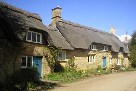
Click image to see photo description.
This Gloucestershire walk starts from the village of Mickleton and follows a circular route around Meon Hill using the Heart of England Way and the Monarch's Way plus a short link through parkland near Kiftsgate Court. The route also allows for a visit to Hidcote Manor (NT) if time permits.
There is limited on street parking in Mickleton close to the ornate drinking fountain (grid ref. SP160436) on the High Street (B4632). After parking walk north on High Street to reach the junction with Back Lane (on your left) a look for the waymark for the Heart of England Way. The path goes underneath an awning between houses and is easy to miss. After 100 metres through a playground you reach a junction of paths. Turn right and follow the waymarked path to the B4632. Go straight across along the track - Canada Lane on some maps (with the access road into the housing estate on your left). Continue along the track until just before two modern industrial units and bear half left along a less distinct path (grid ref. SP166443). Note that older versions of OS maps do not show the new housing estate you have just passed.
Continue on the clear path ahead soon crossing a small footbridge into Warwickshire. 600 metres beyond the footbridge and after crossing fields, the path kinks right and then left to go straight across a field. After this the path follows field boundaries until after 1.5 km you reach a lane on the edge of Upper Quinton (grid ref. SP177461). Join Hill Lane and follow it around to the left. You now to take care and look closely on the right-hand side of the road to spot the waymarks for the Centenary Way and Monarch's Way on a small post by a white house after just over 100 metres along the lane (grid ref. SP177462).
Turn right here between houses. Quite quickly the path bears right and continues across fields, passes Meon Hill on your left and eventually across the grounds of Meon Hall. Reaching the Hall's driveway, turn left down at a road (grid ref. SP185454). Turn right and in a few metres leave the road over a stile on the left. Follow the clear path across fields to reach another lane by Admington Lane Farm (grid ref. SP190446). Turn right following the Monarch's Way. Continue for 400 metres and just after a wide farm track on the left, take the waymarked path also on the left.
The onward path continues through fields, wooded areas and parkland. There are waymarks so do concentrate to make sure you follow the correct route. As a rule, keep straight ahead at every point to reach the parking area for Hidcote Manor (grid ref. SP177429). Turn right across the car park and then left down a lane close to the car park entrance. Continue along the lane through beautiful Hidcote Bartrim and continue to go left of the farm at the end of the lane into a field (grid ref. SP176426). Bear right along the hedge to turn right again after 150 metres and walk half left through the orchard to reach a path junction (grid ref. SP173427) where you leave the Monarch's Way. Turn right and follow the path across the field to a gate and a lane (grid ref. SP173429).
Turn right down the lane as far as a blue gate on the left to follow a bridleway through parkland. After 800 metres you join the Heart of England Way, which comes in at an acute angle from your left. You will see St Lawrence Church ahead. As you near the church trend left to reach a lane (grid ref. SP161434. Turn right down the lane and continue to join High Street (B4632) and the start of the walk.
Other walks nearby
| Walk 2541 | Hidcote & Foxcote from Mickleton | easy/mod | 7.5 miles |
| Walk 3212 | Ebrington & Foxcote circular | easy | 3.7 miles |
| Walk 1308 | Broadway & Chipping Campden | moderate | 11.0 miles |
| Walk 2340 | Ilmington Down | easy/mod | 4.3 miles |
| Walk 2408 | Ebrington & Hidcote from Ilmington | easy/mod | 8.0 miles |
| Walk 3249 | Hidcote & Ilmington Down | easy/mod | 8.0 miles |
| Walk 1359 | Stratford-upon-Avon from Milcote | easy/mod | 7.0 miles |
| Walk 3072 | Broadway, Stanton & Laverton | easy/mod | 7.5 miles |
| Walk 3250 | The Broadway Tower from Broadway | easy/mod | 5.0 miles |
| Walk 3246 | River Avon & Cleeve Prior from Bidford-on-Avon | easy | 4.5 miles |
Recommended Books & eBooks
No suggestions for this area.Messaging & Social Media
Message Walking Britain and follow the latest news.

Mountain Weather
Stay safe on the mountains with detailed weather forecasts - for iOS devices or for Android devices.