Walk 1763 - printer friendly version
Mozie Law & Windy Gyle Walk
Author - Lou Johnson
Length - 8.2 miles / 13.3 km
Ascent - 1600 feet / 485 metres
Grade - moderate
Start - OS grid reference NT860114
Lat 55.396347 + Long -2.222586
Postcode NE65 7BP (approx. location only)
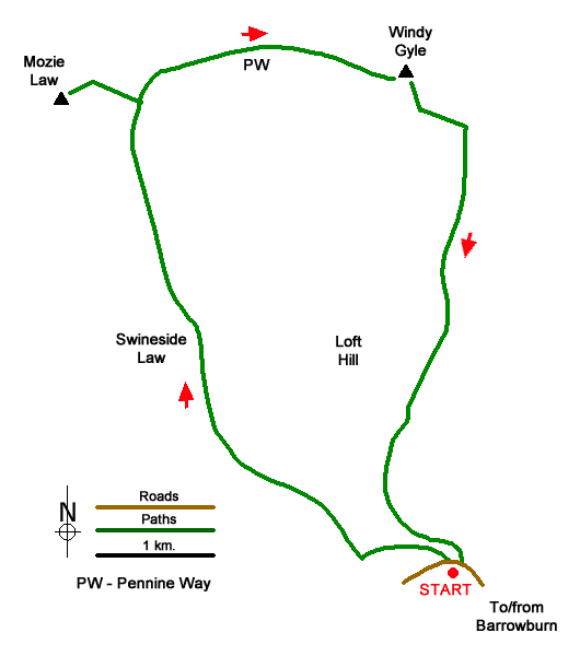
An undulating walk in the Northumberland National Park exploring two hills that straddle the England-Scotland border. The first half of the route follows paths and tracks including a section of the Pennine Way along the border fence. The descent from Windy Gyle follows a grassy path back into the valley.
The start is in the upper Coquet Valley on a minor road a kilometre northwest of Barrowburn where there is a small parking area by a bridge (grid ref. NT859114). The pleasant drive up the valley gives a good impression of the terrain to be encountered during the walk. After parking cross the bridge and take the stile on the right. Head up the clear grassy track with the fence on your left. Continue uphill to the next stile from where the fence is on your right. The grassy track climbs steadily passing across the eastern flank of Swineside Law.
Descend to a grassy col, cross the stile, and continue up the grassy track. Nearing the top of the climb cross another stile and follow the track to reach Plea Know (grid ref. NT835150) with a four-way fingerpost. Turn left over a stile to join the Pennine Way (signed Mozie Law). The grassy path soon becomes paved and follows the fence on your right which leads you to the summit of Mozie Law. Cross the fence (England/Scotland border) to reach the true summit which is in Scotland.
Retrace your steps back top Plea Know. Turn left to follow the Pennine Way in an easterly direction to the summit of Windy Gyle (619 m.) with large cairn topped with an OS trig column. To descend follow the signed path to the Coquet Valley. After leaving the summit the path initially heads south to join a grassy track trending south-east. Follow this track for 350 metres noting that it bears half right to head south (grid ref. NT860148). The path fades in places but makes a gentle descent through Rowhope back to the start.
Messaging & Social Media
Message Walking Britain and follow the latest news.

Mountain Weather
Stay safe on the mountains with detailed weather forecasts - for iOS devices or for Android devices.