Walk 1768 - printer friendly version
Thomas Gill and Ravenseat from Tan Hill Walk
Author - Lou Johnson
Length - 8.7 miles / 14.1 km
Ascent - 1200 feet / 364 metres
Grade - moderate
Start - OS grid reference NY897067
Lat 54.4555810 + Long -2.1603772
Postcode DL11 6ED (approx. location only)
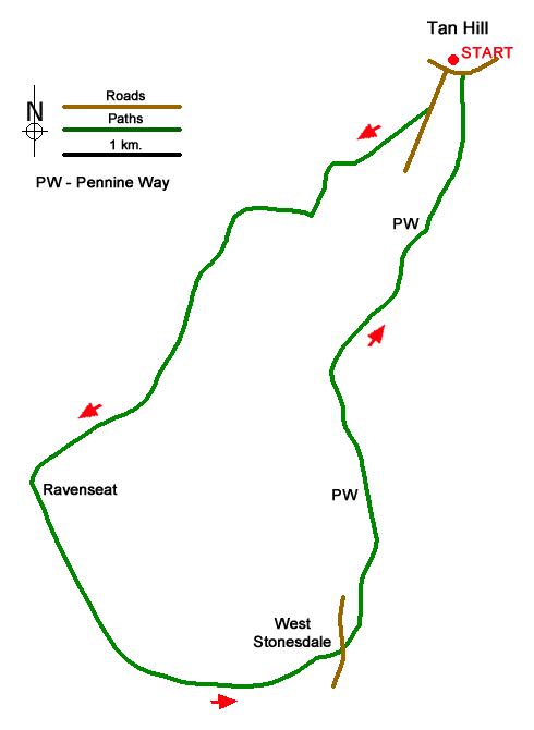
This walk starts from near Tan Hill Inn, the highest pub in Britain and crosses wild moorland to reach Thomas Gill waterfalls before climbing across the flank of Robert's Seat to descend to the isolated farm at Ravenseat. The walk continues following Upper Swaledale before turning north to join the Pennine Way back to the start. In poor visibility the route across the moors could provide problems with navigation.
The start is off-road parking near the Tan Hill Inn (grid ref. NY897067). After parking walk west towards Kirkby Stephen to take the first road on the left signed to Keld and Thwaite. Follow the road for 150 metres and take the signed footpath on the right. The path crosses moorland running parallel to Tan Gill on your left to descend into a shallow valley. The path turns south (grid ref. NY887060) where it crosses Tan Gill to follow Stonesdale Beck to pass some old sheep pens. The path then swings west crossing Stonesdale Beck and climbs uphill above a gully containing Thomas Gill and a waterfall.
At the far end of the gully (grid ref. NY879056) the path swings left to cross the eastern flank of Robert's Seat which rises on your right. Continue for just over a kilometre to reach a stile in a fence (grid ref. NY872042). The descending path soon crosses another stile with Pryclose Gutter down to your left. Continue over another stile continue to a gate on your left and drop down to Ravenseat Farm. The onward route is over a stile (by a gate) between a barn and the farmhouse. This leads into a yard. Keep ahead through a gate (signed to Keld).
Continue ahead across rough pasture with Whitsundale below on your right. The terrain changes to moorland. After just over a kilometre, you reach a fork in the path (grid ref. NY869022). Keep left here on path that contours across the hillside to reach the road at West Stonesdale (grid ref. NY888021). Turn left and then right through a gate just past a cottage. Pass through a second gate and then drop down to valley floor. Head upstream and cross a bridge and continue upstream with the beck on your left. Towards the end of the second field bear right up to a small gate in a wall. Pass above and to the right of a barn. Continue climbing across rough pasture, cross a beck and head up to an awkward stile in the wall above (near power pole).
Maintain direction to join the Pennine Way. Bear left and follow the clear path. The route briefly follows the access track for Frith Lodge. Where the track goes left, keep ahead past a barn. Continue through gates onto Stonesdale Moor. The path becomes less obvious soon crossing a bridge over Lad Gill (grid ref. NY887045). The route starts to climb eventually reaching a track (grid ref. NY897061). Bear left and continue back to the Tan Hill Inn.
Messaging & Social Media
Message Walking Britain and follow the latest news.

Mountain Weather
Stay safe on the mountains with detailed weather forecasts - for iOS devices or for Android devices.